ID: 435
Open
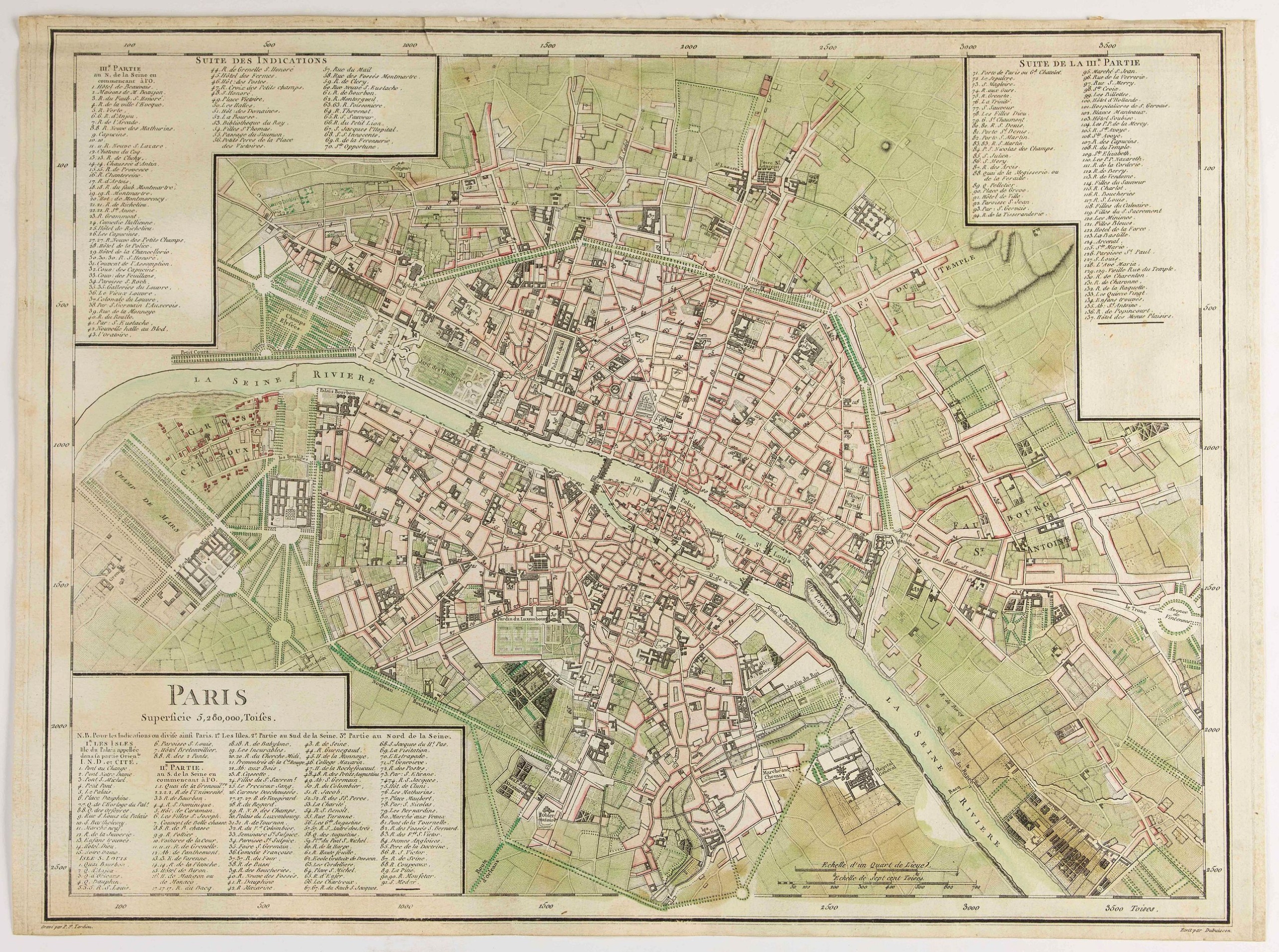
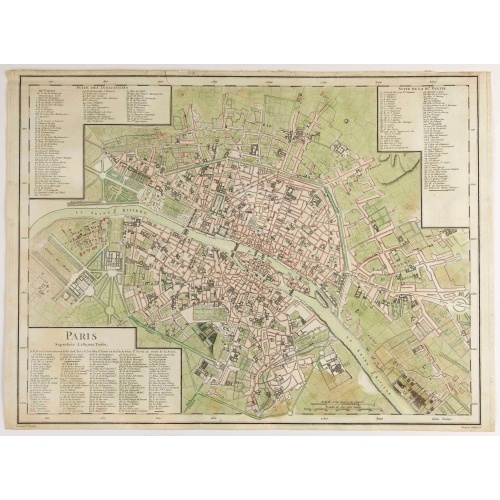
Paris Superficie 5,280,000 Toises.
BuyNow for €600
- Maker :
- TARDIEU, P. F.
- Place :
- Paris
- Date :
- 1779-1782
- Color :
- In original color
- Height mm.:
- 340
- Width mm.:
- 450
- Condition :
- Dark impression, on thick paper. Short margins.
- Bibliography :
- J. Boutier, Les Plans de Paris, 320 first edition.
- Seller's ref. :
- 48424
This item is offered by Librairie_Loeb-Larocque
See other Items from this seller- Postage
-
France
€15 to France
- Select Country
- Zip/Post Code
- Quantity
€600
Description
FIRST EDITION of this finely engraved plan of Paris by P. F. Tardieu and prepared by DuBuisson. This detailed plan of Paris includes la Place Louis XV, la Bastille, but does not have the city walls. The first edition was included in " l'Atlas nouveau" of E. Mentelle.
The second state (after 1792) has the text "Plan routier de la ville de Paris…", in the righthand lettered key, added.
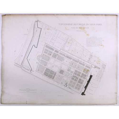
Topographie historique du vieux Paris / Plan de restitution Feuille V bis.
Copper engraved plan centered on gardens of the Louvre by Jean-Joseph Sulpis (1826–1911) after a model by Adolphe Berty. Plate 5bis from "Topographie historique du vieux Paris". The publication was started by Adolphe Berty and continued by H. Legrand and L.-M. Tisserand, Th. Vacquer and Camille Platon.
€50
Maker : BERTY, A.
Place : Paris
Date : 1866-1897
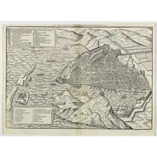
Le vray portraict de la Ville de Marseille.
Fine wood cut bird's-eye view of Marseille. Decorated with several ship in the harbour and on the sea. To the left two keys describing the main buildings and places. Published in "La Cosmographie Universelle de tout le monde", printed in 1575 in Paris by Nicolas Chesneau and Michel Sonnius with the French text by Francois de Belleforest.The book is a French version of Sebastian Münster's "Cosmographia Universalis".
€800
Maker : BELLEFOREST, F. de.
Place : Paris
Date : 1575
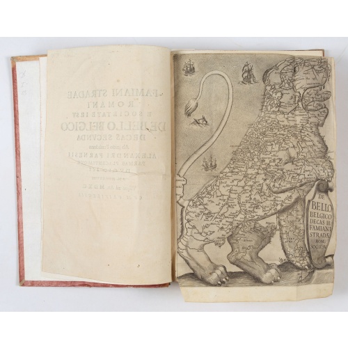
De Bello Belgico, Decas Prima / Decas Secunda.
With 2 engraved titles of the 'Leo Belgicus', with one paw resting on a shield bearing the title, large woodcut printer's device on the colophons, and 30 richly engraved views and plans of battles and sieges, 28 double-page and 2 full-page, by Johanness W.Bauer, J.Miele, Jacomo Cortese, a.o. Two examples of the famous Leo Belgicus map are included. Among the greatest decorative works of early cartography is a series of arresting maps showing The Netherlands and Belgium in the shape of a lion.Thi...
€6.900
Maker : STRADA, Famiano.
Place : Rome, Franciscus Corbelletus
Date : 1632-1647
![[Upper sheet map only] The Provinces New York, and New Jersey with part of Pensilvania and the Province of Quebec.](/uploads/cache/25624-500x500.jpg)
[Upper sheet map only] The Provinces New York, and New Jersey with part of Pensilvania and the Province of Quebec.
Rare separately issued map, unfortunately only the upper part of the map. It is a variant of this important colonial map. The upper sheet showing the upper course of the St. Lawrence River. With 3 large insets: 1) A Chart of the Mouth of Hudson's River from Sandy Hook to New York. This is in effect a chart of New York Harbor, with depth soundings, shoals, and other marine information laid down. 2) A Plan of Amboy. The city of Perth Amboy, the old capital of New Jersey, and the most important por...
€750
Maker : HOLLAND, S./ BROENNER, H.L.
Place : Frankfurt
Date : 1777
Postage & Shipping
-
Item Location
Terms and conditions - Item Location
- 75013, Ile-de-France, France
- Ships To
- United States, United Kingdom, Albania, Argentina, Armenia, Australia, Austria, Bahamas, Belgium, Bermuda, Bosnia and Herzegowina, Brazil, Bulgaria, Canada, Chile, China, Costa Rica, Denmark, Dominica, Egypt, El Salvador, Finland, France, Germany, Greece, Guatemala, Hong Kong, Hungary, Iceland, India, Italy, Japan, Korea (South), Kuwait, Liechtenstein, Lithuania, Luxembourg, Madagascar, Mexico, Monaco, Morocco, Netherlands, Netherlands Antilles, New Zealand, Norway, Paraguay, Peru, Philippines, Poland, Portugal, Qatar, Reunion, Romania, San Marino, Saudi Arabia, Seychelles, Singapore, Slovenia, South Africa, Spain, Sri Lanka, Suriname, Sweden, Switzerland, Taiwan, Thailand, Tunisia, Turkey, United Arab Emirates, Uruguay, Vietnam
- Pick-ups
- Buyer can pick-up
This item is owned and offered by the seller Librairie_Loeb-Larocque - All items are available for immediate sale, offered subject to prior sale.
Invoices are created by the seller by using our shopping cart or be prepared by the seller the day following the order and are emailed to you.
Items offeres by different sellers are invoiced separately.
Shipping fees are extra. The buyer is responsible for all applicable taxes, including any VAT, customs clearance, import duties, or equivalent costs arriving at the customer's home border. Payment is due on receipt of the invoice. The item(s) are shipped as soon as possible after receipt of your payment.
Before buying please read the complete Terms Conditions of Sale.
- Payment Methods
- Visa, Mastercard, Bank Transfer, American Express, iDEAL, PayPal, Google Pay
- Returns Accepted
- No
Post Message
Feel free to ask the seller a question. Please note that the seller could be located in an area with a different time zone. Our seller will do their best to respond within 24 hours.Post your message below.
Sign in to ask the seller a question.