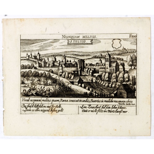
ID: 485
Open
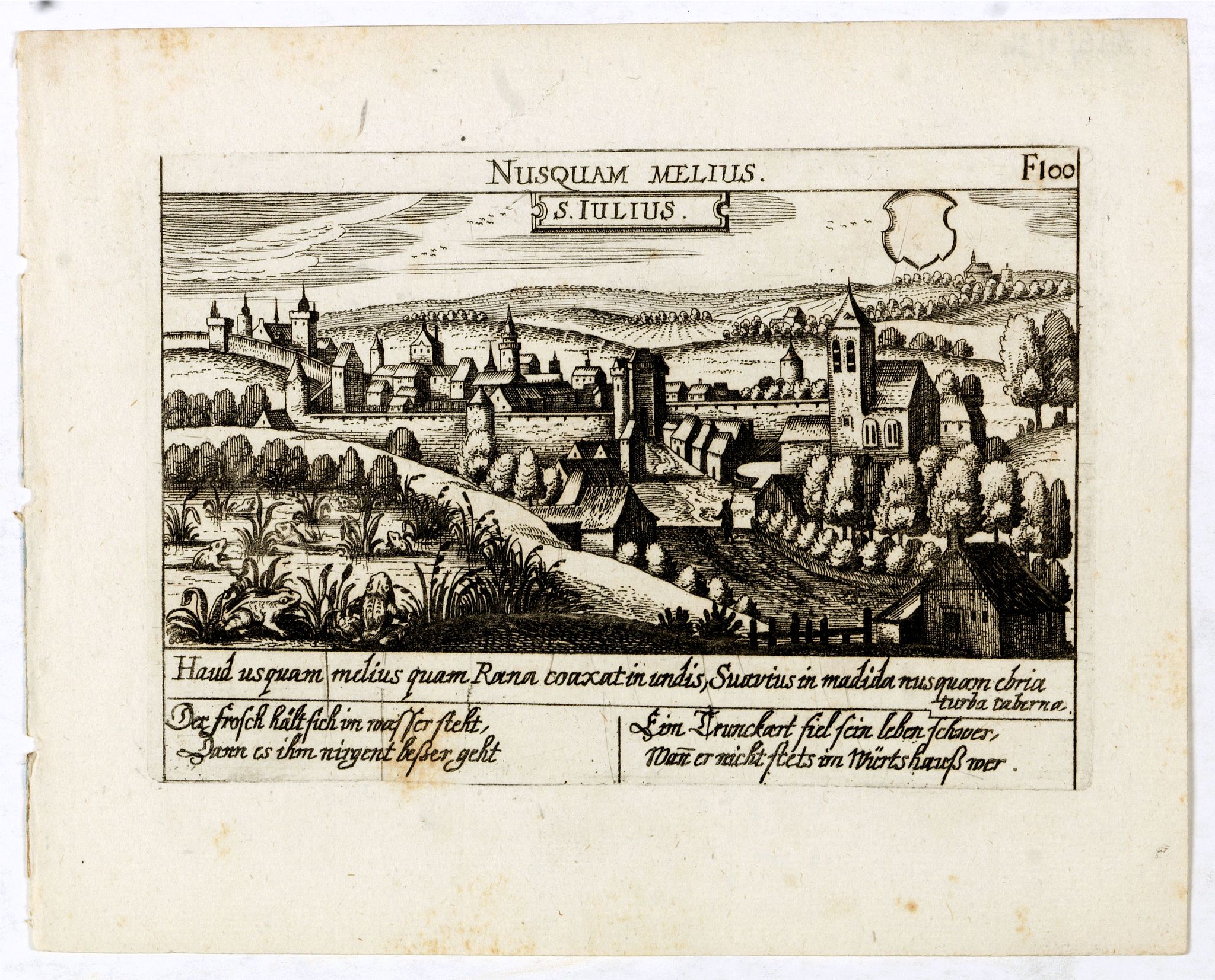
S. Iulius.
BuyNow for €60
- Maker :
- MEISNER, D.
- Place :
- Frankfurt
- Date :
- 1623-1678
- Color :
- Uncoloured
- Height mm.:
- 100
- Width mm.:
- 145
- Condition :
- A good and dark impression. Very good.
- Bibliography :
- Fauser, Repertorium Älter Topographie,7920.
- Seller's ref. :
- 13816
This item is offered by Librairie_Loeb-Larocque
See other Items from this seller- Postage
-
France
€15 to France
- Select Country
- Zip/Post Code
- Quantity
€60
Description
A very nice view of the castle of Saint Julius. On the foreground, several frogs are depicted. With a verse in two languages underneath the picture.
By 1625 the collection included 362, which had increased to 800 the end of the century, when the last edition was published.
Among the master engravers who contributed to this series, usually working from earlier sources, were Matthäus Merian, Sebastian Furck, Christian Stimmer and Meisner himself.
A rare and attractive print rich in allegorical imagery, the Meisner engravings are masterful examples of Renaissance art and culture.
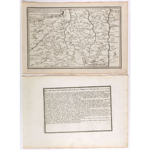
Gouvernement general du Lionnois, generalitez de Lion et de Riom . . .
Map of central France with Clermont-Ferrand and Lyon to the right, from Nicolas de Fer's "L'Atlas curieux ou le Monde réprésente dans des cartes. "The "Atlas Curieux" is a geographic encyclopedia of images and a celebration of the French Empire under the Sun King, with maps of French possessions in the western hemisphere, maps of France, with detailed views of the grand waterworks at Marly, views of the great palaces and chateaux, views and plans of the Paris Observatory, and samples of milita...
€60
Maker : DE FER, N.
Place : Paris
Date : 1705
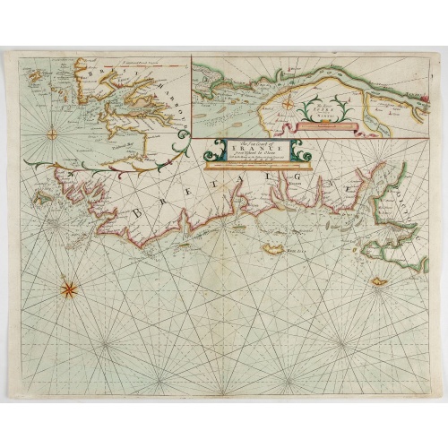
The Sea Coast of France from Ushent to Olone.
Chart showing the Brittany coast from Ushent to Ollone, with Belle-Ile. In insets : Rade de Brest and Mouth of the Loire between St. Nazaire and Nantes.Originally engraved by John Seller, here with the address "Sold by Ri. Mount at the Postern on Great Tower Hill LONDON". Mount and Page was a firm of religious and maritime publishers that flourished in the 18th century. The name became well-known worldwide as an imprint of nautical charts.The firm was founded in 1701 by Richard Mount (1654–172...
€550
Maker : MOUNT, R.. / PAGE, T.
Place : London, ca. 1680
Date : 1680
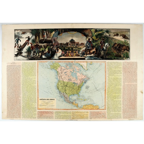
América del Norte.
Very attractive large map of North America with stunning panorama at top of figures representing the continents, etc. A rare and decorative map. From "Atlas geográfico universal texto redactado bajo la dirección de Dr. D. Juan Vilanova parte artística bajo la dirección de Otto Neussel Dibº geogrº J.P. Morales, cromo litogrº Ginés Ruiz".Good hand color on panorama and original lithographic color on the map. The most ambitious of all the monographs and scientific works by Spanish geographe...
€550
Maker : ASTORT HERMANOS EDITORES
Place : Madrid
Date : 1877
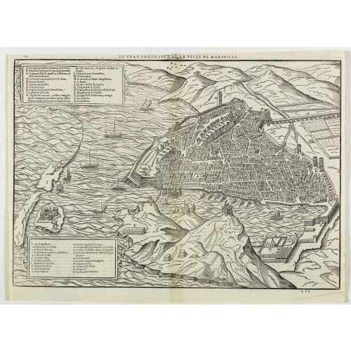
Le vray portraict de la Ville de Marseille.
Fine wood cut bird's-eye view of Marseille. Decorated with several ship in the harbour and on the sea. To the left two keys describing the main buildings and places. Published in "La Cosmographie Universelle de tout le monde", printed in 1575 in Paris by Nicolas Chesneau and Michel Sonnius with the French text by Francois de Belleforest.The book is a French version of Sebastian Münster's "Cosmographia Universalis".
€800
Maker : BELLEFOREST, F. de.
Place : Paris
Date : 1575
Postage & Shipping
-
Item Location
Terms and conditions - Item Location
- 75013, Ile-de-France, France
- Ships To
- United States, United Kingdom, Albania, Argentina, Armenia, Australia, Austria, Bahamas, Belgium, Bermuda, Bosnia and Herzegowina, Brazil, Bulgaria, Canada, Chile, China, Costa Rica, Denmark, Dominica, Egypt, El Salvador, Finland, France, Germany, Greece, Guatemala, Hong Kong, Hungary, Iceland, India, Italy, Japan, Korea (South), Kuwait, Liechtenstein, Lithuania, Luxembourg, Madagascar, Mexico, Monaco, Morocco, Netherlands, Netherlands Antilles, New Zealand, Norway, Paraguay, Peru, Philippines, Poland, Portugal, Qatar, Reunion, Romania, San Marino, Saudi Arabia, Seychelles, Singapore, Slovenia, South Africa, Spain, Sri Lanka, Suriname, Sweden, Switzerland, Taiwan, Thailand, Tunisia, Turkey, United Arab Emirates, Uruguay, Vietnam
- Pick-ups
- Buyer can pick-up
This item is owned and offered by the seller Librairie_Loeb-Larocque - All items are available for immediate sale, offered subject to prior sale.
Invoices are created by the seller by using our shopping cart or be prepared by the seller the day following the order and are emailed to you.
Items offeres by different sellers are invoiced separately.
Shipping fees are extra. The buyer is responsible for all applicable taxes, including any VAT, customs clearance, import duties, or equivalent costs arriving at the customer's home border. Payment is due on receipt of the invoice. The item(s) are shipped as soon as possible after receipt of your payment.
Before buying please read the complete Terms Conditions of Sale.
- Payment Methods
- Visa, Mastercard, Bank Transfer, American Express, iDEAL, PayPal, Google Pay
- Returns Accepted
- No
Post Message
Feel free to ask the seller a question. Please note that the seller could be located in an area with a different time zone. Our seller will do their best to respond within 24 hours.Post your message below.
Sign in to ask the seller a question.

-500x500.jpg)