ID: 403
Open
![[The strange sheep-like creatures that carried the silver .]](/uploads/40481.jpg)
[The strange sheep-like creatures that carried the silver .]
BuyNow for €80
- Maker :
- GOTTFRIED, J.L. / DE BRY.
- Place :
- Frankfurt, M.Merian, 1633
- Date :
- 1633
- Color :
- Uncoloured
- Height mm.:
- 145
- Width mm.:
- 185
- Condition :
- Copper plate engraving on text sheet. Paper lightly browned as usual, lower right margin missing, white tape repair to lower margin, stains and soling to margins etc.
Size of sheet : 345 x 217 mm. German text. - Bibliography :
- -
- Seller's ref. :
- 40481
This item is offered by Librairie_Loeb-Larocque
See other Items from this seller- Postage
-
France
€15 to France
- Select Country
- Zip/Post Code
- Quantity
€80
Description
When the Spanish discovered the silver mines of Potosí, they organised the transport of the rich ore westward by llama trains across the Altiplano and down to Arica on the coast, where it would be transported by ship to Panama.These strange creatures would sit down when angered or overburdened and, neither beatings nor kind words would make the animals get up again. If any of them ran away, they had to be shot to recover their valuable cargo.
In 1631, Johann Ludwig Gottfried inherited Theodor De Bry’s publishing firm, among the illustrated accounts of the expeditions of Magellan, Columbus, Vespucci, Cortés, Balboa, Raleigh, Drake, Smith, and many others.
Gottfried issued together with Matthaeus Merian a one-volume condensation "Newe Welt Vnd Americanische Historien/ Jnhaltende Warhafftige vnd volkommene Beschreibungen Aller West-Jndianischen Landschafften..." that used many of the original copper plates and supplemented them with new ones of more recent voyages. The book was published by Matthaeus Merian.
The work was reprinted in 1655 / 1657.
![[Spanish take over Cusco] / [Atahualpa is garrotted].](/uploads/cache/41092-500x500.jpg)
[Spanish take over Cusco] / [Atahualpa is garrotted].
Two engravings. [486] After Atahualpa was killed, Pizarro set out with his troops to find the city of Cuzco, which he had heard was rich in gold. The journey from Cajamarca to Cuzco by road was nearly a thousand miles and took three months. Although there was considerable resistance to the Spanish during this long march, the final descent into the great city, in November 1533, was in fact, not as portrayed but a relatively peaceful affair. [485] While Atahualpa was still held captive rumors spre...
€80
Maker : GOTTFRIED, J.L. / DE BRY.
Place : Frankfurt, M.Merian
Date : 1633
![S. Victor in Franckr. [Paris].](/uploads/cache/13781-500x500.jpg)
S. Victor in Franckr. [Paris].
A very nice view of St. Victor church in Paris. In the foreground, a night watchman is depicted. With a verse in Latin and German underneath the picture. The German text reads : "Auff dass nicht mög der Wandersman, Sein Füss verletzen uff dem plan, von dem Fusseisen so merct mich, er muss wandern fursichtiglich."
€60
Maker : MEISNER, D.
Place : Frankfurt
Date : 1623-1678
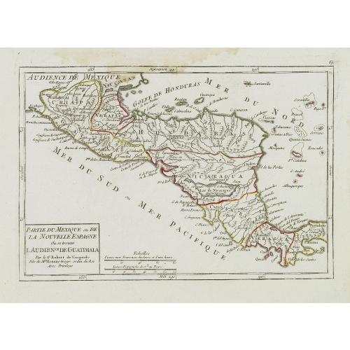
Partie du Mexique ou de la Nouvelle Espagne Où se trouve l'Audience de Guatimala.
Nice small map of Central America, extending from the Yucatán Peninsula to Panama. From Atlas Portatif Universel, by Robert de Vaugondy.From Atlas Portatif Universel, by Robert de Vaugondy.Page 89 outside border top right. Mary Sponberg Pedley does not mention a state with this number.
€50
Maker : VAUGONDY, R. de
Place : Paris
Date : later than 1749
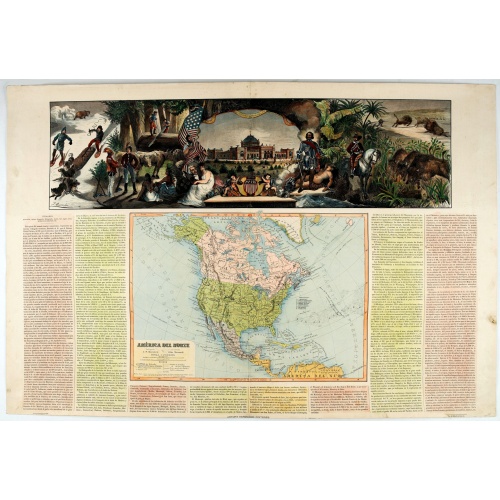
América del Norte.
Very attractive large map of North America with stunning panorama at top of figures representing the continents, etc. A rare and decorative map. From "Atlas geográfico universal texto redactado bajo la dirección de Dr. D. Juan Vilanova parte artística bajo la dirección de Otto Neussel Dibº geogrº J.P. Morales, cromo litogrº Ginés Ruiz".Good hand color on panorama and original lithographic color on the map. The most ambitious of all the monographs and scientific works by Spanish geographe...
€550
Maker : ASTORT HERMANOS EDITORES
Place : Madrid
Date : 1877
Postage & Shipping
-
Item Location
Terms and conditions - Item Location
- 75013, Ile-de-France, France
- Ships To
- United States, United Kingdom, Albania, Argentina, Armenia, Australia, Austria, Bahamas, Belgium, Bermuda, Bosnia and Herzegowina, Brazil, Bulgaria, Canada, Chile, China, Costa Rica, Denmark, Dominica, Egypt, El Salvador, Finland, France, Germany, Greece, Guatemala, Hong Kong, Hungary, Iceland, India, Italy, Japan, Korea (South), Kuwait, Liechtenstein, Lithuania, Luxembourg, Madagascar, Mexico, Monaco, Morocco, Netherlands, Netherlands Antilles, New Zealand, Norway, Paraguay, Peru, Philippines, Poland, Portugal, Qatar, Reunion, Romania, San Marino, Saudi Arabia, Seychelles, Singapore, Slovenia, South Africa, Spain, Sri Lanka, Suriname, Sweden, Switzerland, Taiwan, Thailand, Tunisia, Turkey, United Arab Emirates, Uruguay, Vietnam
- Pick-ups
- Buyer can pick-up
This item is owned and offered by the seller Librairie_Loeb-Larocque - All items are available for immediate sale, offered subject to prior sale.
Invoices are created by the seller by using our shopping cart or be prepared by the seller the day following the order and are emailed to you.
Items offeres by different sellers are invoiced separately.
Shipping fees are extra. The buyer is responsible for all applicable taxes, including any VAT, customs clearance, import duties, or equivalent costs arriving at the customer's home border. Payment is due on receipt of the invoice. The item(s) are shipped as soon as possible after receipt of your payment.
Before buying please read the complete Terms Conditions of Sale.
- Payment Methods
- Visa, Mastercard, Bank Transfer, American Express, iDEAL, PayPal, Google Pay
- Returns Accepted
- No
Post Message
Feel free to ask the seller a question. Please note that the seller could be located in an area with a different time zone. Our seller will do their best to respond within 24 hours.Post your message below.
Sign in to ask the seller a question.
![[The strange sheep-like creatures that carried the silver .]](/uploads/cache/40481-500x500.jpg)