ID: 354
Open
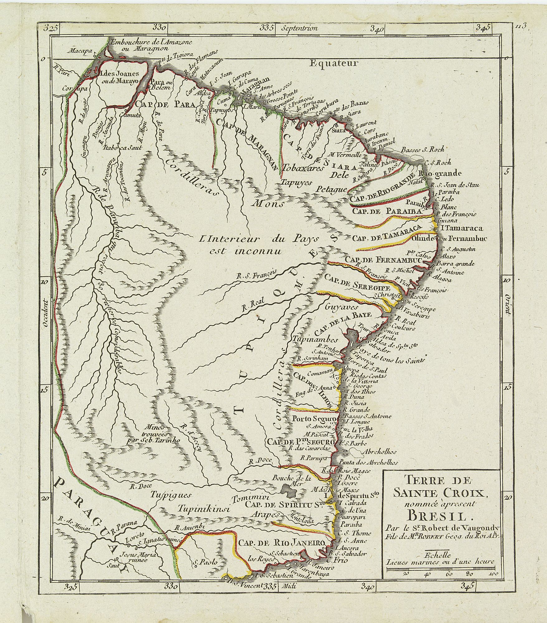
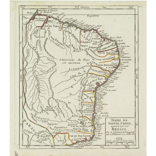
Terre de Sainte Croix, nommée à présent Bresil.
BuyNow for €75
- Maker :
- VAUGONDY, R. de
- Place :
- Paris
- Date :
- later than 1749
- Color :
- In original outline colors
- Height mm.:
- 195
- Width mm.:
- 162
- Condition :
- Very crisp and fine image. Upper margin short as issued. Very light marginal water staining, affecting the upper scale border. Good condition.
- Bibliography :
- Pedley, Bel et utile, map 497, not mentioning this state.
- Seller's ref. :
- 24605
This item is offered by Librairie_Loeb-Larocque
See other Items from this seller- Postage
-
France
€15 to France
- Select Country
- Zip/Post Code
- Quantity
€75
Description
Detailed small map showing most part of the Brazilian seacoasts, from the mouth of the Amazon River as far as the island of Sao Sebastiao.From Atlas Portatif Universel, by Robert de Vaugondy.
111 outside border top right. Mary Sponberg Pedley does not mention a state without date.
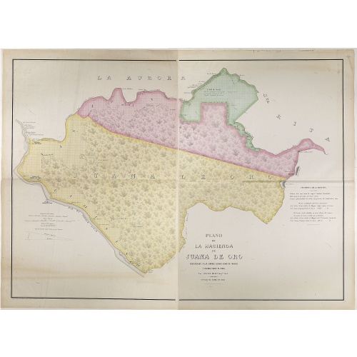
Plano de la Hacienda de Juana de Oro.
Wall-map sized map in 2 sheets, if joined 940 x 1300mm., showing the Hacienda (farm) of Juana de Oro in Ecuador. The cocoa farm was owned by Mrs. Leonor Carbo of Higgins and Virginia Carbo of Icaza. Cocoa plantations are depicted on the map by a multitude of shrubs. This plan provides information on cocoa productivity and distribution among the owners.
€750
Maker : DILLON, A.
Place : Guayaquil ( Equateur)
Date : 1868
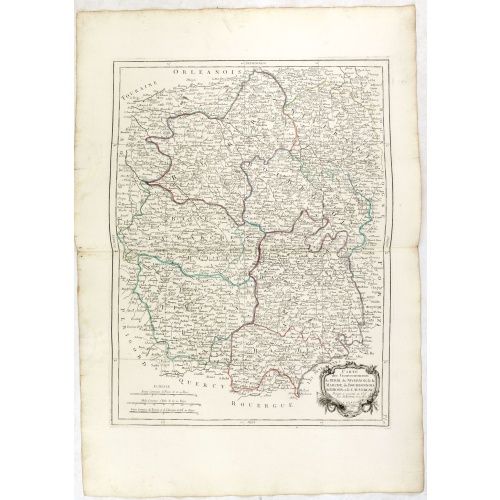
Gouvernements de Berri, du Nivernois,de la Marche, Limousin..
Detailed map encompassing Berri, Nivernois, Limousin and Auvergne.Venetian edition of the map by Bonne, to whom Santini gives credit in the cartouche.From "Atlas Universel" published by Santini in 1776-84. The atlas is effectively an Italian copy of the Robert de Vaugondy 'Atlas Universel'.In 1784 Santini sold the plates to M. Remondini, whose name appears on this particular example.
€75
Maker : SANTINI,P. / REMONDINI,M.
Place : Venice
Date : 1776 - 1784
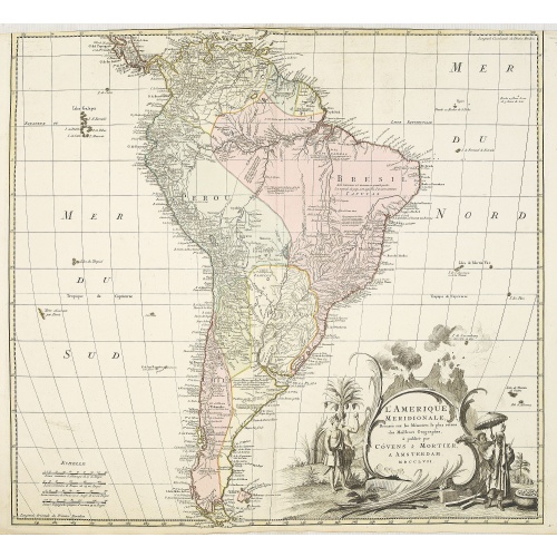
L'amerique meridionale dressee sur les memoires le plus recens. . .
Rare and decorative map of South America with good detail and interesting notations concerning the explorations of the interior. With in the lower right corner a title cartouche flanked by natives with a background of erupting volcanoes.The Amsterdam publishing firm of Covens and Mortier (1721 - c. 1862) was the successor to the extensive publishing empire built by Frenchman Pierre Mortier (1661 - 1711). Upon Mortier's death in 1711 his firm was taken over by his son, Cornelius Mortier (1699 -...
€550
Maker : COVENS, J. / MORTIER, C.
Place : Amsterdam
Date : 1757
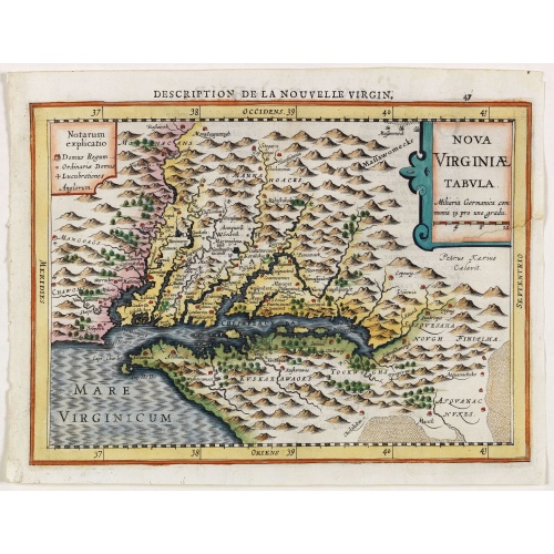
Virginiae item et Floridae . . .
Map of Virginia from the rare Cloppenburg edition slightly larger format and more scarce edition of the Mercator/Hondius "Atlas Minor". Engraved by Pieter Van Den Keere.The Cloppenburg edition "Atlas Sive Cosmographicae Meditationes De Fabrica Mundi Et Fabricati Figura", was continued for a couple of years but seems to have been suppressed after 1636 ... (Koeman Atlantes Neerlandici).Based on the 1595 Abraham Ortelius map, but with added decoration.
€750
Maker : MERCATOR, G. / CLOPPENBURGH, J.E.
Place : Amsterdam
Date : 1630
Postage & Shipping
-
Item Location
Terms and conditions - Item Location
- 75013, Ile-de-France, France
- Ships To
- United States, United Kingdom, Albania, Argentina, Armenia, Australia, Austria, Bahamas, Belgium, Bermuda, Bosnia and Herzegowina, Brazil, Bulgaria, Canada, Chile, China, Costa Rica, Denmark, Dominica, Egypt, El Salvador, Finland, France, Germany, Greece, Guatemala, Hong Kong, Hungary, Iceland, India, Italy, Japan, Korea (South), Kuwait, Liechtenstein, Lithuania, Luxembourg, Madagascar, Mexico, Monaco, Morocco, Netherlands, Netherlands Antilles, New Zealand, Norway, Paraguay, Peru, Philippines, Poland, Portugal, Qatar, Reunion, Romania, San Marino, Saudi Arabia, Seychelles, Singapore, Slovenia, South Africa, Spain, Sri Lanka, Suriname, Sweden, Switzerland, Taiwan, Thailand, Tunisia, Turkey, United Arab Emirates, Uruguay, Vietnam
- Pick-ups
- No pick-ups
This item is owned and offered by the seller Librairie_Loeb-Larocque - All items are available for immediate sale, offered subject to prior sale.
Invoices are created by the seller by using our shopping cart or be prepared by the seller the day following the order and are emailed to you.
Items offeres by different sellers are invoiced separately.
Shipping fees are extra. The buyer is responsible for all applicable taxes, including any VAT, customs clearance, import duties, or equivalent costs arriving at the customer's home border. Payment is due on receipt of the invoice. The item(s) are shipped as soon as possible after receipt of your payment.
Before buying please read the complete Terms Conditions of Sale.
- Payment Methods
- Visa, Mastercard, Bank Transfer, American Express, iDEAL, PayPal, Google Pay
- Returns Accepted
- No
Post Message
Feel free to ask the seller a question. Please note that the seller could be located in an area with a different time zone. Our seller will do their best to respond within 24 hours.Post your message below.
Sign in to ask the seller a question.