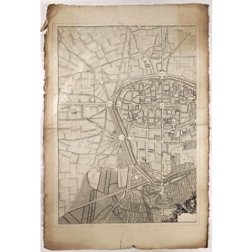
Plan de la ville et du château de Caën en Normandie.
Plan of the city of Caen, from Nicolas de Fer's "L'Atlas curieux ou le Monde réprésente dans des cartes. "The "Atlas Curieux" is a geographic encyclopedia of images and a celebration of the French Empire under the Sun King, with maps of French possessions in the western hemisphere, maps of France, with detailed views of the grand waterworks at Marly, views of the great palaces and chateaux, views and plans of the Paris Observatory, and samples of military architecture. Issued in six annual par...
€60
Maker : DE FER, N.
Place : Paris, 1705
Date : 1705
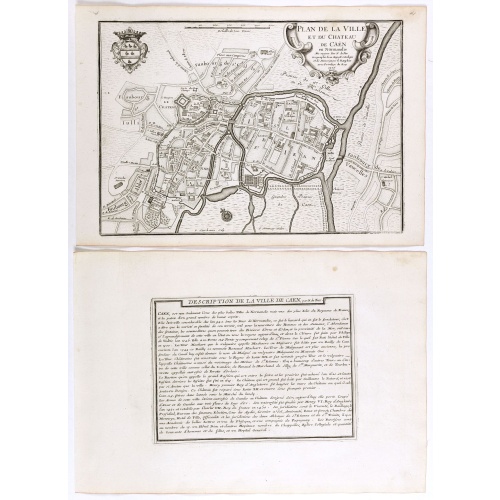
Plan general des chateaux et ville de St Germain en Laye.
City plan of St Germain en Laye, from Nicolas de Fer's "L'Atlas curieux ou le Monde réprésente dans des cartes. "The "Atlas Curieux" is a geographic encyclopedia of images and a celebration of the French Empire under the Sun King, with maps of French possessions in the western hemisphere, maps of France, with detailed views of the grand waterworks at Marly, views of the great palaces and chateaux, views and plans of the Paris Observatory, and samples of military architecture. Issued in six ann...
€60
Maker : DE FER, N.
Place : Paris
Date : 1705
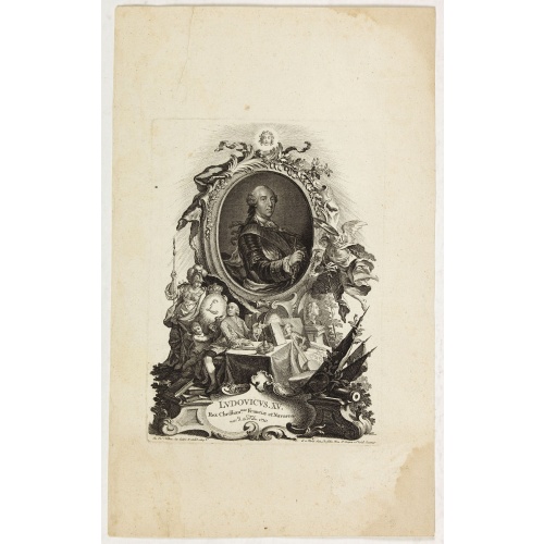
Ludovicus. XV rex chrisitan franciae et navarrae nat d:15. febr. 1710.
Portrait of Ludovicus XV, set in a decorative border.In lower part "Jo. Es. Nilson, inv et excutiv Aug V. et à Paris chez Rosselin Rue St. Jaques a l'Autel Saumur". Prepared by Johann Esaias Nilson (1721-88), 'the German Watteau'. Nilson was part of a family of artists and established himself as the leading Augsburg artist of his day, whose influence extended across publishing, art academies, a role as court painter, and the decorative arts (especially ceramics).Louis XV, known as Louis the Bel...
€50
Maker : NILSON, J.E.
Place : Augsburg, Paris
Date : 1710

(Clermont, Brioude, Le Puy, etc.)
Rare miniature map including the towns of Clermont, Brioude, Le Puy, etc. From "Le theatre De Bellone, Contenant 48. nouvelles Cartes Geographiques, Des Païs-Bas Espagnols, Provinces-Unies, haute & basse Allemagne. . .". This rare atlas contained maps relating to the War of Spanish Succession. Published in Amsterdam by the widow of P. Schenk.
€60
Maker : SCHENK, P.
Place : Amsterdam
Date : 1710
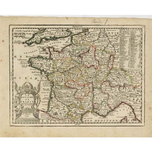
Le Royaume de France..
Lovely small map of France with decorative title cartouche and a panel in the upper right corner listing local rulers.From Le Nouveau et Curieux Atlas Geographique et Historique.. by Jacques Chiquet.Together with an engraved French text sheet entitled Le Royaume de France.
€75
Maker : CHIQUET, J.
Place : Paris
Date : 1719
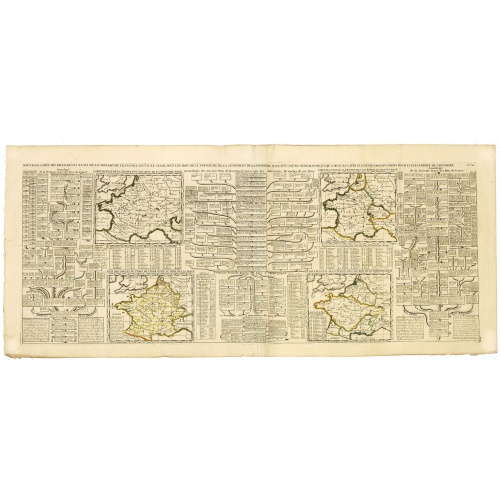
Nouvelle Carte des Differents Etats de la Monarchie Françoise Sous Iule Cesar, Sous les Rois de la Premiere, de la Seconde . . .
Four maps of France surrounded by historical and genealogical information to the history, chronology, ancient and modern genealogy of the french monarchy.Henri Abraham Chatelain (1684 – 1743) was a Huguenot pastor of Parisian origins. He lived consecutively in Paris, St. Martins, London (c. 1710), the Hague (c. 1721) and Amsterdam (c. 1728). He is best known as a Dutch cartographer and more specifically for his cartographic contribution in the seminal seven volume Atlas Historique, published f...
€75
Maker : CHATELAIN, H.
Place : Amsterdam
Date : 1720

Particularitez Curieuses de l'Ile de St. Christophle et de la Province de Bemarin . . .
Six meticulously detailed and engraved scenes of the island of St. Kitts, also known as Saint Christopher, and the province of Bemarin, indigenous plants, animals, reptiles, fish, crustaceans and insects.On a single sheet from Volume Six of Chatelain's "Atlas Historique".From left to right, top, the illustrations depict the French General's palace on St. Kitts, Indians visiting the French, and a landscape in Bemarin Province. Zacharie Chatelain (d.1723) was the father of Henri Abraham (1684-1743...
€95
Maker : CHATELAIN, H.
Place : Amsterdam
Date : 1720
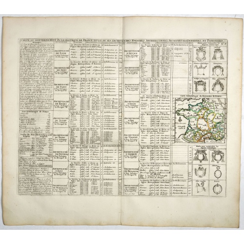
Carte du Gouvernement Ecclesiastique de France Divise en ses Archeveschez, Eveschez, Archidiaconnez, Archipretrez, Doyennez, et Parroisses.
This impressive plate provides a comprehensive list of the ecclesiastical divisions in the country with their corresponding coats of arms. A small inset map depicts the location of the various churches across France (95 x 105mm.)Zacharie Chatelain (d.1723) was the father of Henri Abraham (1684-1743) and Zacharie Junior (1690-1754).They worked as a partnership publishing the Atlas Historique, Ou Nouvelle Introduction A L’Histoire … under several different Chatelain imprints, depending on the ...
€55
Maker : CHATELAIN, H.
Place : Amsterdam, 1720
Date : 1720
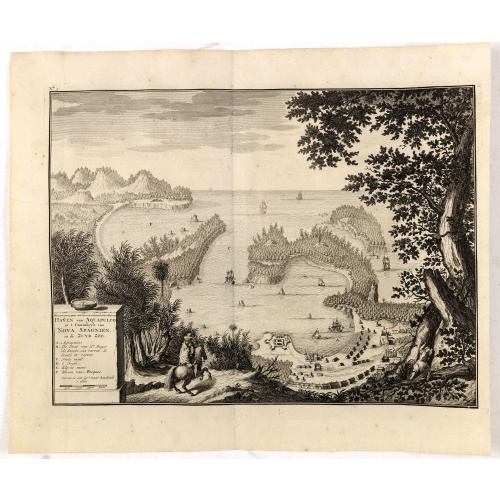
Haven van Aquapulco in ' Coninkryk van Nova Spagnien in de Zuyd Zee.
A finely engraved plan of the harbor, fort and village of Acapulco drawn from a hilltop vantage point looking out to sea. Several galleons are pictured approaching or anchored in the harbor. After Johannes Vingboons.François Valentijn (1666-1727), a missionary, worked at Amboina from 1684 to 1694 and 1705 to 1713 and traveled extensively in the VOC's lands. He is best known for his monumental history and description, "Oud en Nieuw Oost-Indiën" which remains one of the most important primary so...
€650
Maker : VALENTIJN, F.
Place : Amsterdam
Date : 1726
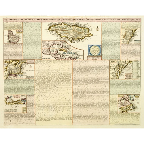
Carte qui contient..Iles & Terres..L'Amerique..Jamaique..
Eight maps on one sheet. From Chatelain's Atlas Historique et Méthodique . Including maps of Bermuda, Jamaica, New England with Long Island, Carolina, Chesapeake and Delaware Bay, Nova Scotia and a map of the Caribbean.
€500
Maker : CHATELAIN, H.
Place : Amsterdam
Date : 1728
![(Chatelain "Atlas Historique" in 7 volumes.]](/uploads/cache/47053X-500x500.jpg)
(Chatelain "Atlas Historique" in 7 volumes.]
Henri Abraham Chatelain, whose Atlas Historique was one of the most expansive encyclopedias of the age. First published in 1705, Chatelain's Atlas Historique was part of an immense seven-volume encyclopedia. Although the main focus of the text was geography, the work also included a wealth of historical, political, and genealogical information. The text was compiled by Nicholas Gueudeville and Garillon with a supplement by H.P. de Limiers and the maps were engraved by Chatelain, primarily after...
€40.000
Maker : CHATELAIN, H.
Place : Amsterdam: Chez Zacharie Châtelain
Date : 1732 - 1739
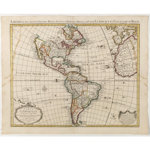
Carte d'Amerique dressée par l'usage du Roy..
Fine map prepared by G.d'Isle depicting North and south America, the west coast taken north to Cap Mendocin and Cap Blanc with a note Entrée decouverte par Martin d'Aguilar .The re-engraved Amsterdam edition, with the lettering within the title cartouche copied from the issue of the first edition with the florid lettering for d'Amerique. Dated 1739.
€700
Maker : COVENS, J. / MORTIER, C.
Place : Amsterdam
Date : 1739
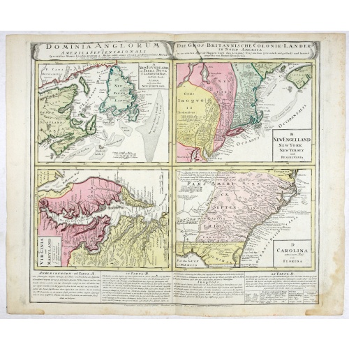
Dominia Anglorum in America Septentrionali.
Four maps on one sheet (New Found land/ New England/ Virginia and Carolina/Florida) based on J.B.Homann's map, showing British possessions in North America. The upper left shows territory in Newfoundland and around the Bay of St. Lawrence, with portions of the ‘lost’ colony of New Scotland. The Grand Banks are prominently noted as well. The map immediately to the right shows claims in New York and New England, with large areas in Pennsylvania noted as belonging to the Iroquois. The lower lef...
€750
Maker : HOMANN HEIRS.
Place : Nuremberg 1740
Date : 1740
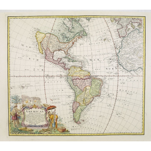
Americae Mappa generalis.
Johann Baptist Homann's well-engraved second map of America has a large decorative cartouche. Detailed map of the western hemisphere.The interior of North America has new details supplied by the Jesuits, especially along the Mississippi River and English and Dutch information along the coast.The Great Lakes after D'Anville. The NW Coast of America and NW Passage are still unknown. Quivira -the legendary land of gold and silver- is shown considerably east of its normal location. Johann Baptist Ho...
€700
Maker : HOMANN HEIRS. / HAAS, J.M.
Place : Nuremberg
Date : 1746
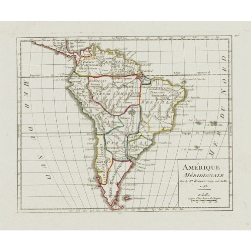
Amérique Méridionale.
Nice small map of South America. Dated 1748. From Atlas Portatif Universel, by Robert de Vaugondy.Page 105 outside border top right. Mary Sponberg Pedley does not mention a state without date.
€75
Maker : VAUGONDY, R. de
Place : Paris
Date : later than 1748
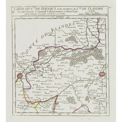
III. Carte du C.té de Haynaut et des Frontieres du C.té de Flandre..
Attractive small map encompassing part of the Nord, between Douai and Valenciennes.From Atlas Portatif Universel, by Robert de Vaugondy.Unrecorded state with erased date. Page 14c outside border top right. Mary Sponberg Pedley does not mention a state without date.
€50
Maker : VAUGONDY, R. de
Place : Paris
Date : after 1748
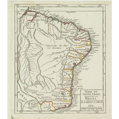
Terre de Sainte Croix, nommée à présent Bresil.
Detailed small map showing most part of the Brazilian seacoasts, from the mouth of the Amazon River as far as the island of Sao Sebastiao.From Atlas Portatif Universel, by Robert de Vaugondy. 111 outside border top right. Mary Sponberg Pedley does not mention a state without date.
€75
Maker : VAUGONDY, R. de
Place : Paris
Date : later than 1749

Partie du Mexique ou de la Nouvelle Espagne Où se trouve l'Audience de Guatimala.
Nice small map of Central America, extending from the Yucatán Peninsula to Panama. From Atlas Portatif Universel, by Robert de Vaugondy.From Atlas Portatif Universel, by Robert de Vaugondy.Page 89 outside border top right. Mary Sponberg Pedley does not mention a state with this number.
€50
Maker : VAUGONDY, R. de
Place : Paris
Date : later than 1749
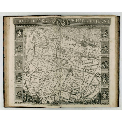
't Hooge Heemraedschap van Delfland met alle de Steden, Dorpen, Ambachten, Litmaten, Polders, (etc.).
The so-called Kruquius map is a wall-map of the Delfland water board district. The map consists of 25 engraved map sheets. Several maps flanked by fine large armorial cartouches. All sheets together cover a wall map with a total area of 230 x 280 cm. The map was often bound in a rich gilted calf binding and presented as gifts to important persons. The atlas than included also the overview map. According to Prof. Koeman "Thanks to the quality of the cartography (a “sensitive” scale of 1:10,00...
€3.750
Maker : KRUIKIUS, N. / J.
Place : Delft
Date : 1712-1750