ID: 127
Open
Listing ID: #127 has been added to your wishlist.
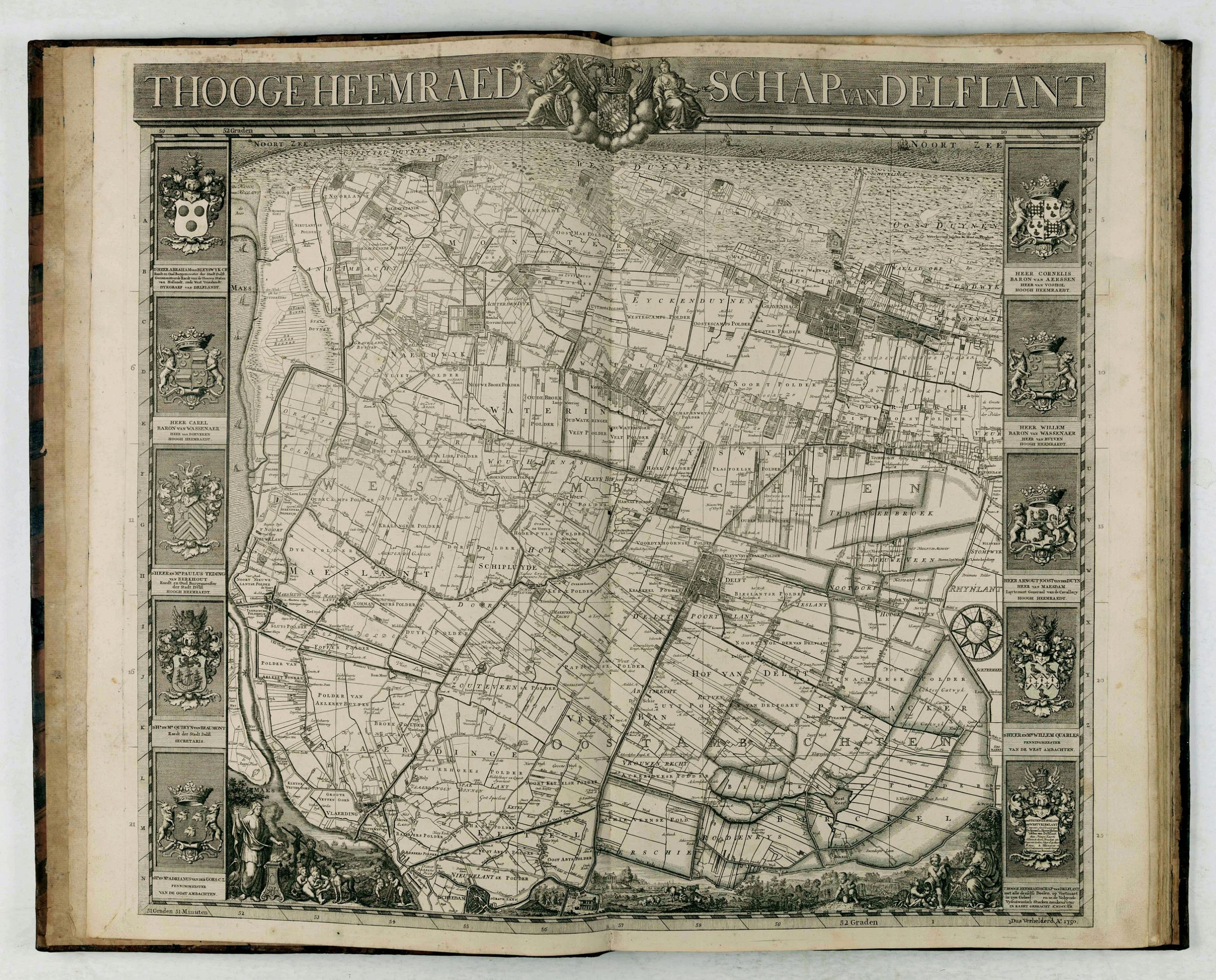
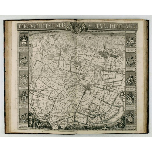
't Hooge Heemraedschap van Delfland met alle de Steden, Dorpen, Ambachten, Litmaten, Polders, (etc.).
BuyNow for €3.750
- Maker :
- KRUIKIUS, N. / J.
- Place :
- Delft
- Date :
- 1712-1750
- Color :
- Uncoloured
- Height mm.:
- 580
- Width mm.:
- 430
- Condition :
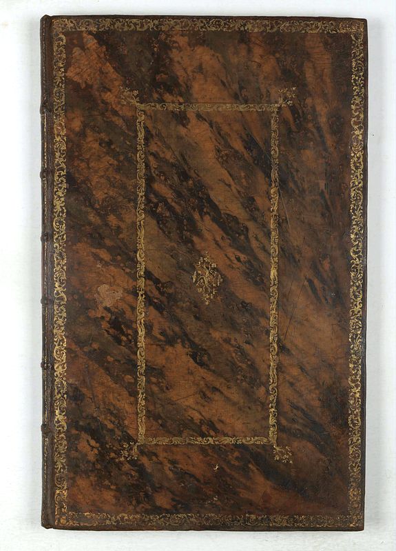
- Large-folio. Cont. mottled calf with raised bands, richly decorated. gilt back, gilt lettering 'Delfland' on both sides, surrounded by 2 gilt decorated. borders. Engraved title in 2 parts, engr. general map (2nd, altered edition, dated 1750) 25 numbered
- Bibliography :
- -
- Seller's ref. :
- 45658
This item is offered by Librairie_Loeb-Larocque
See other Items from this seller- Postage
-
Standard Shipping
€0 to Netherlands
- Select Country
- Zip/Post Code
- Quantity
€3.750
Description
The so-called Kruquius map is a wall-map of the Delfland water board district. The map consists of 25 engraved map sheets. Several maps flanked by fine large armorial cartouches. All sheets together cover a wall map with a total area of 230 x 280 cm. The map was often bound in a rich gilted calf binding and presented as gifts to important persons. The atlas than included also the overview map.According to Prof. Koeman "Thanks to the quality of the cartography (a “sensitive” scale of 1:10,000 was used) rather than its size, the map surpasses all other water authority maps which were produced in the 17th and 18th centuries".
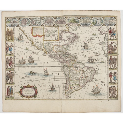
Americae Nova Tabula.
An inset shows Greenland and Iceland. Decorative elements include ships, sea monsters, and vignettes of native Americans within South America. In addition, the map is bordered by a series of nine maps and birds-eye views at the top (including Cusco, Havana, and Mexico City) and ten ethnographic views of various Native Americans.The delineation of the coast and the nomenclature on both the Pacific and Atlantic coasts are basically Spanish in origin and follow the maps of Ortelius and Wytfliet. To...
€6.500
Maker : BLAEU, W.
Place : Amsterdam
Date : 1644
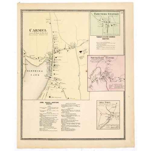
Town of Carmel / Towners Station / South East Centre / Mill Town.
Fine lithographed map of the town of Carmel / Towners Station / South East Centre / Mill Town. From "Atlas of New York and vicinity" published by Beers, Ellis & Soule, 95 Maiden Lane, New York.The map provides the names of specific homeowners, as well as information about the occupations and physical locations of the various tradesmen in each village from Beer's famous county atlas "Atlas of New York and vicinity," "a documentary record of nineteenth-century life and delightful specimens of Ame...
€80
Maker : DE BEERS, F. W.
Place : New York
Date : 1867
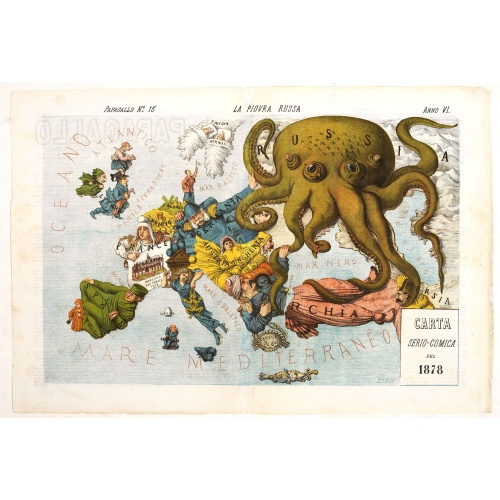
La Piovra Russa. Carta Serio-Comica Pel 1878.
Very rare political caricature map by Grossi of the nations of Europe, published in Bologna in the supplement of the newspaper "Le Perroquet / Al papagallo, N° 15, Anno VI.Known as the Octopus Map ; the brooding presence of the Russian Empire depicted as a massive octopus, whose tentacles stretch out towards Europe. In this map, the Octopus has Turkey, Persia and Poland but has been wounded by Crimea and is being fought off by Germany.This map, by Grossi, followed the style created by Frederick...
€1.850
Maker : GROSSI, A.
Place : Bologne
Date : 14 avril 1878
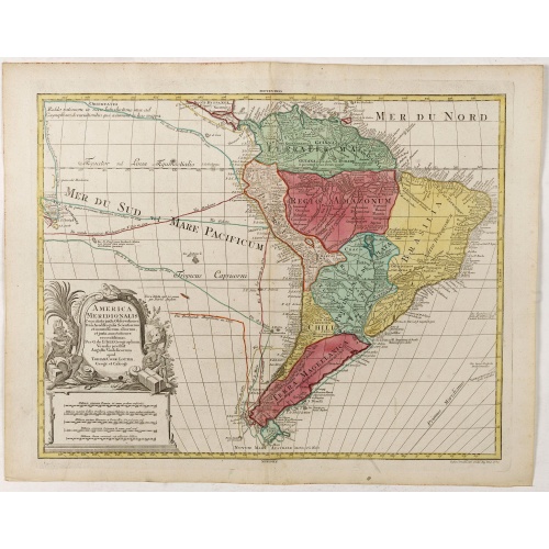
America Meridionalis.
The title cartouche lower left surrounded by native Indians and an Elephant.A rather accurate depiction and descriptions of South America. Brazil is slightly enlarged and bears mainly names of the costal zone. The inland was rather unknown at the time and regarded as both pagan and dangerous area like the Amazon.Argentina with Cape Horn and the Falkland Islands are merely deformed. The map was published by Matthäus Seutter's son in law Tobias Conrad Lotter, who continued the cartographical work...
€700
Maker : LOTTER, T.C.
Place : Augsburg
Date : ca. 1760
Postage & Shipping
-
Item Location
Terms and conditions - Item Location
- 75013, Ile-de-France, France
- Ships To
- United States, United Kingdom, Albania, Argentina, Armenia, Australia, Austria, Bahamas, Belgium, Bermuda, Bosnia and Herzegowina, Brazil, Bulgaria, Canada, Chile, China, Costa Rica, Denmark, Dominica, Egypt, El Salvador, Finland, France, Germany, Greece, Guatemala, Hong Kong, Hungary, Iceland, India, Italy, Japan, Korea (South), Kuwait, Liechtenstein, Lithuania, Luxembourg, Madagascar, Mexico, Monaco, Morocco, Netherlands, Netherlands Antilles, New Zealand, Norway, Paraguay, Peru, Philippines, Poland, Portugal, Qatar, Reunion, Romania, San Marino, Saudi Arabia, Seychelles, Singapore, Slovenia, South Africa, Spain, Sri Lanka, Suriname, Sweden, Switzerland, Taiwan, Thailand, Tunisia, Turkey, United Arab Emirates, Uruguay, Vietnam
- Pick-ups
- No pick-ups
This item is owned and offered by the seller Librairie_Loeb-Larocque - All items are available for immediate sale, offered subject to prior sale.
Invoices are created by the seller by using our shopping cart or be prepared by the seller the day following the order and are emailed to you.
Items offeres by different sellers are invoiced separately.
Shipping fees are extra. The buyer is responsible for all applicable taxes, including any VAT, customs clearance, import duties, or equivalent costs arriving at the customer's home border. Payment is due on receipt of the invoice. The item(s) are shipped as soon as possible after receipt of your payment.
Before buying please read the complete Terms Conditions of Sale.
- Payment Methods
- Visa, Mastercard, Bank Transfer, American Express, iDEAL, PayPal, Google Pay
- Returns Accepted
- No
Post Message
Feel free to ask the seller a question. Please note that the seller could be located in an area with a different time zone. Our seller will do their best to respond within 24 hours.Post your message below.
Sign in to ask the seller a question.
![[Spilbergen's fleet visits the island of Santa Maria] / [The Dutch visit Isla Mocha].](/uploads/cache/41090-500x500.jpg)