
ID: 391
Open
![[Spilbergen's fleet visits the island of Santa Maria] / [The Dutch visit Isla Mocha].](/uploads/41090.jpg)
[Spilbergen's fleet visits the island of Santa Maria] / [The Dutch visit Isla Mocha].
BuyNow for €80
- Maker :
- GOTTFRIED, J.L. / DE BRY.
- Place :
- Frankfurt, M.Merian
- Date :
- 1633
- Color :
- Uncoloured
- Height mm.:
- 150
- Width mm.:
- 195
- Condition :
- Copper plate engraving on text sheet. Paper lightly browned and stained, as is usual. Size of sheet: 345 x 222 mm. German text and on verso.
- Bibliography :
- www.history-engraved.org/ Chile 513-514
- Seller's ref. :
- 41090
This item is offered by Librairie_Loeb-Larocque
See other Items from this seller- Postage
-
France
€15 to France
- Select Country
- Zip/Post Code
- Quantity
€80
Description
Two engravings. [514] On 29th May, 1615, Spilbergen’s fleet anchored further north, off an island called Santa María that was separated by a narrow stretch of water (A), from Punta Lavapié on the mainland. Four of the ships (I) anchored in the bay, while the fifth (H) anchored closer. The Dutch went ashore in small boats (F), where they saw Spanish soldiers on horseback (B), so they arranged themselves for battle (C). There were several confrontations (E), during which many Dutchmen died but they still managed to burn the town of Santa María in the process (D).[513] Spilbergen’s fleet anchored off the island of Mocha on 24th April 1615, fifteen years after Noort’s landing. The crew went ashore in several small rowing boats (A), and offered to barter with the Indians for axes and knives (B). The locals, who were simply dressed (K), brought fruit, chicken and sheep (G)*. Later the Dutch entertained the inhabitants of the island on the beach with music, played with flutes and drums (D). While four of the ships anchored some distance off-shore (I), one of them came in (H), in case of danger.
The sheep had humps on their backs, like camels, but were probably llamas or alpacas
In 1631 Johann Ludwig Gottfried, inherited the Theodor De Bry’s publishing firm, among the illustrated accounts of the expeditions of Magellan, Columbus, Vespucci, Cortes, Balboa, Raleigh, Drake, Smith, and many others.
Gottfried issued together with Matthaeus Merian a one-volume condensation "Newe Welt Vnd Americanische Historien/ Jnhaltende Warhafftige vnd volkommene Beschreibungen Aller West-Jndianischen Landschafften..." that used many of the original copper plates and supplemented them with new ones of more recent voyages. The book was published by Matthaeus Merian. The work was reprinted in 1655 / 1657.
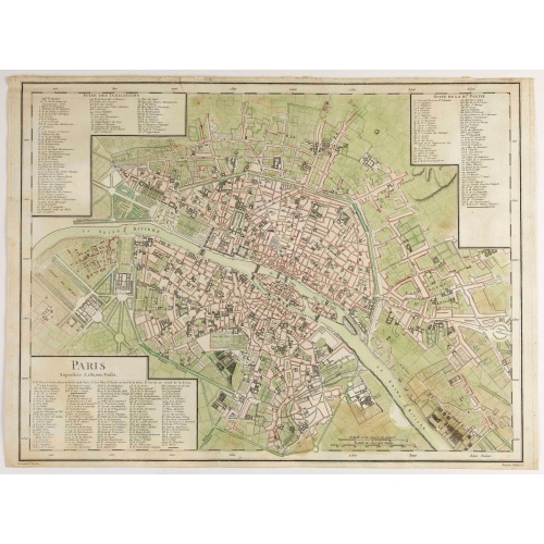
Paris Superficie 5,280,000 Toises.
FIRST EDITION of this finely engraved plan of Paris by P. F. Tardieu and prepared by DuBuisson. This detailed plan of Paris includes la Place Louis XV, la Bastille, but does not have the city walls. The first edition was included in " l'Atlas nouveau" of E. Mentelle. The second state (after 1792) has the text "Plan routier de la ville de Paris…", in the righthand lettered key, added.
€600
Maker : TARDIEU, P. F.
Place : Paris
Date : 1779-1782
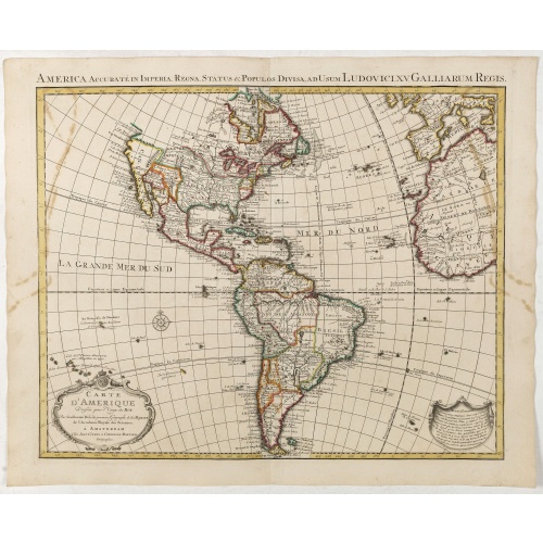
Carte d'Amerique dressée par l'usage du Roy..
Fine map prepared by G.d'Isle depicting North and south America, the west coast taken north to Cap Mendocin and Cap Blanc with a note Entrée decouverte par Martin d'Aguilar .The re-engraved Amsterdam edition, with the lettering within the title cartouche copied from the issue of the first edition with the florid lettering for d'Amerique. Dated 1739.
€700
Maker : COVENS, J. / MORTIER, C.
Place : Amsterdam
Date : 1739
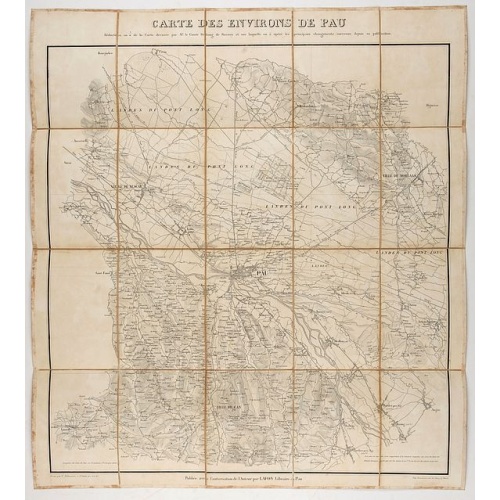
Carte des environs de Pau. . .
Folding map of Pau and its surroundings, being a reduced version of the map by Comte Dulong de Rosnay and engraved by Nicolas Delamare and published by Lafon.
€75
Maker : VCOMTE DULONG DE ROSNAY
Place : Pau, Lafon
Date : 1840-1850
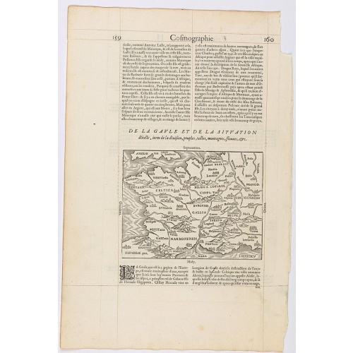
Page from La Cosmographie Universelle with map of France. (Page 160)
Text page with woodblock map of ancient France (122 x 163 mm.) In 1575 Sebastian Münster's Cosmographia was translated into French and published in Paris by François de Belle-Forest.
€75
Maker : DE BELLE-FOREST, F.
Place : Paris
Date : 1575
Postage & Shipping
-
Item Location
Terms and conditions - Item Location
- 75013, Ile-de-France, France
- Ships To
- United States, United Kingdom, Albania, Argentina, Armenia, Australia, Austria, Bahamas, Belgium, Bermuda, Bosnia and Herzegowina, Brazil, Bulgaria, Canada, Chile, China, Costa Rica, Denmark, Dominica, Egypt, El Salvador, Finland, France, Germany, Greece, Guatemala, Hong Kong, Hungary, Iceland, India, Italy, Japan, Korea (South), Kuwait, Liechtenstein, Lithuania, Luxembourg, Madagascar, Mexico, Monaco, Morocco, Netherlands, Netherlands Antilles, New Zealand, Norway, Paraguay, Peru, Philippines, Poland, Portugal, Qatar, Reunion, Romania, San Marino, Saudi Arabia, Seychelles, Singapore, Slovenia, South Africa, Spain, Sri Lanka, Suriname, Sweden, Switzerland, Taiwan, Thailand, Tunisia, Turkey, United Arab Emirates, Uruguay, Vietnam
- Pick-ups
- Buyer can pick-up
This item is owned and offered by the seller Librairie_Loeb-Larocque - All items are available for immediate sale, offered subject to prior sale.
Invoices are created by the seller by using our shopping cart or be prepared by the seller the day following the order and are emailed to you.
Items offeres by different sellers are invoiced separately.
Shipping fees are extra. The buyer is responsible for all applicable taxes, including any VAT, customs clearance, import duties, or equivalent costs arriving at the customer's home border. Payment is due on receipt of the invoice. The item(s) are shipped as soon as possible after receipt of your payment.
Before buying please read the complete Terms Conditions of Sale.
- Payment Methods
- Visa, Mastercard, Bank Transfer, American Express, iDEAL, PayPal, Google Pay
- Returns Accepted
- No
Post Message
Feel free to ask the seller a question. Please note that the seller could be located in an area with a different time zone. Our seller will do their best to respond within 24 hours.Post your message below.
Sign in to ask the seller a question.
![[Spilbergen's fleet visits the island of Santa Maria] / [The Dutch visit Isla Mocha].](/uploads/cache/41090-500x500.jpg)
-500x500.jpg)