ID: 407
Open
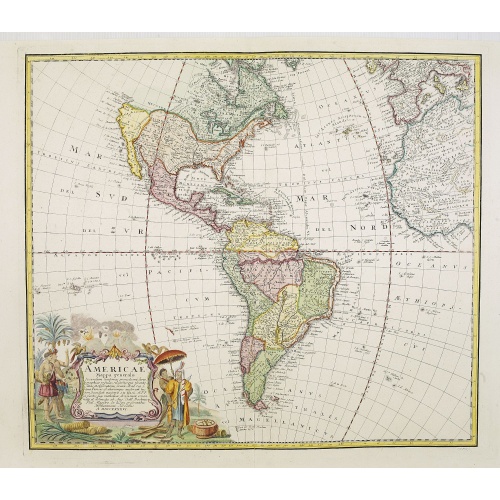
Americae Mappa generalis.
BuyNow for €700
- Maker :
- HOMANN HEIRS. / HAAS, J.M.
- Place :
- Nuremberg
- Date :
- 1746
- Color :
- Colored
- Height mm.:
- 465
- Width mm.:
- 535
- Condition :
- Repair of split lower part center fold, 3cm. Into engraved area, hardly notable. Good impression.
- Bibliography :
- Lowery Collection #383. Wagner #1746.
- Seller's ref. :
- 26071
This item is offered by Librairie_Loeb-Larocque
See other Items from this seller- Postage
-
France
€15 to France
- Select Country
- Zip/Post Code
- Quantity
€700
Description
Johann Baptist Homann's well-engraved second map of America has a large decorative cartouche. Detailed map of the western hemisphere.The interior of North America has new details supplied by the Jesuits, especially along the Mississippi River and English and Dutch information along the coast.
The Great Lakes after D'Anville. The NW Coast of America and NW Passage are still unknown. Quivira -the legendary land of gold and silver- is shown considerably east of its normal location.
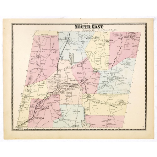
Town of South East.
Fine lithographed map of the town of South East. From : "Atlas of New York and vicinity" published by Beers, Ellis & Soule, 95 Maiden Lane, New York.The map provides the names of specific homeowners, as well as information about the occupations and physical locations of the various tradesmen in each village from Beer's famous county atlas "Atlas of New York and vicinity, a documentary record of nineteenth-century life and delightful specimens of American folk art."F. W. Beers, along with other m...
€90
Maker : DE BEERS, F.W.
Place : New York, 1867
Date : 1867
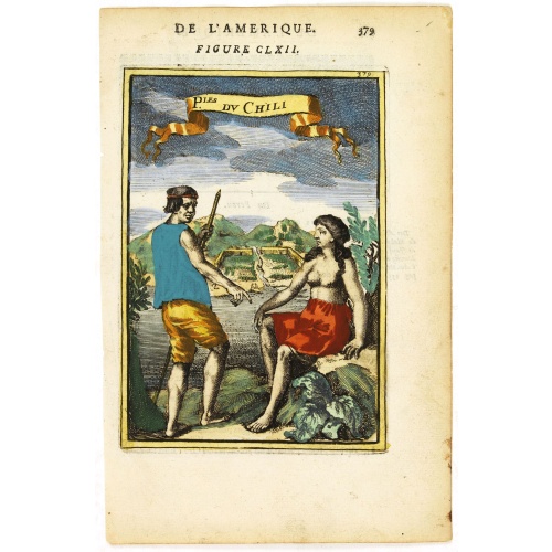
P.les du Chile.
A charming copper engraving depicting a town surrounded by a luxuriant landscape on the background and a couple of indigenous on the foreground.From the French text edition of Description d'Univers, 1683. by Allain Manneson Mallet (1630-1706), a well traveled military engineer and geographer who worked in 17th century France under King Louis XIV.
€60
Maker : MALLET, A.M.
Place : Paris
Date : 1683
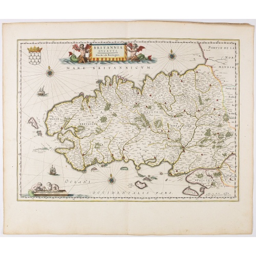
Britannia Ducatus. Duché de Bretaigne.
Map of Bretagne in France. From early on Willem Jansz. Blaeu aimed of publishing an atlas to compete with the Hondius-Jansson Atlas. By 1630, he had published at least 17 folio size maps. Blaeu was able to realize his plan soon after he had acquired the copper plates of the atlas maps by Jodocus Hondius. The "Appendix followed in 1630.In 1635 he finally realized a "international edition" of a world atlas, the "Theatrum Orbis Terrarum".
€650
Maker : BLAEU, W.
Place : Amsterdam
Date : 1644
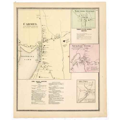
Town of Carmel / Towners Station / South East Centre / Mill Town.
Fine lithographed map of the town of Carmel / Towners Station / South East Centre / Mill Town. From "Atlas of New York and vicinity" published by Beers, Ellis & Soule, 95 Maiden Lane, New York.The map provides the names of specific homeowners, as well as information about the occupations and physical locations of the various tradesmen in each village from Beer's famous county atlas "Atlas of New York and vicinity," "a documentary record of nineteenth-century life and delightful specimens of Ame...
€80
Maker : DE BEERS, F. W.
Place : New York
Date : 1867
Postage & Shipping
-
Item Location
Terms and conditions - Item Location
- 75013, Ile-de-France, France
- Ships To
- United States, United Kingdom, Albania, Argentina, Armenia, Australia, Austria, Bahamas, Belgium, Bermuda, Bosnia and Herzegowina, Brazil, Bulgaria, Canada, Chile, China, Costa Rica, Denmark, Dominica, Egypt, El Salvador, Finland, France, Germany, Greece, Guatemala, Hong Kong, Hungary, Iceland, India, Italy, Japan, Korea (South), Kuwait, Liechtenstein, Lithuania, Luxembourg, Madagascar, Mexico, Monaco, Morocco, Netherlands, Netherlands Antilles, New Zealand, Norway, Paraguay, Peru, Philippines, Poland, Portugal, Qatar, Reunion, Romania, San Marino, Saudi Arabia, Seychelles, Singapore, Slovenia, South Africa, Spain, Sri Lanka, Suriname, Sweden, Switzerland, Taiwan, Thailand, Tunisia, Turkey, United Arab Emirates, Uruguay, Vietnam
- Pick-ups
- Buyer can pick-up
This item is owned and offered by the seller Librairie_Loeb-Larocque - All items are available for immediate sale, offered subject to prior sale.
Invoices are created by the seller by using our shopping cart or be prepared by the seller the day following the order and are emailed to you.
Items offeres by different sellers are invoiced separately.
Shipping fees are extra. The buyer is responsible for all applicable taxes, including any VAT, customs clearance, import duties, or equivalent costs arriving at the customer's home border. Payment is due on receipt of the invoice. The item(s) are shipped as soon as possible after receipt of your payment.
Before buying please read the complete Terms Conditions of Sale.
- Payment Methods
- Visa, Mastercard, Bank Transfer, iDEAL, PayPal
- Returns Accepted
- No
Post Message
Feel free to ask the seller a question. Please note that the seller could be located in an area with a different time zone. Our seller will do their best to respond within 24 hours.Post your message below.
Sign in to ask the seller a question.