ID: 452
Open
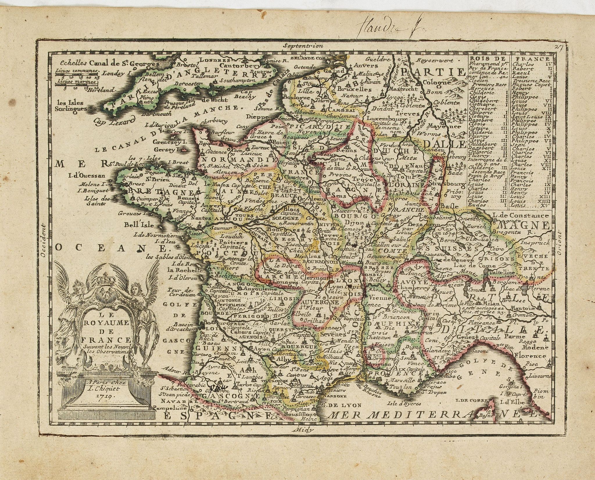
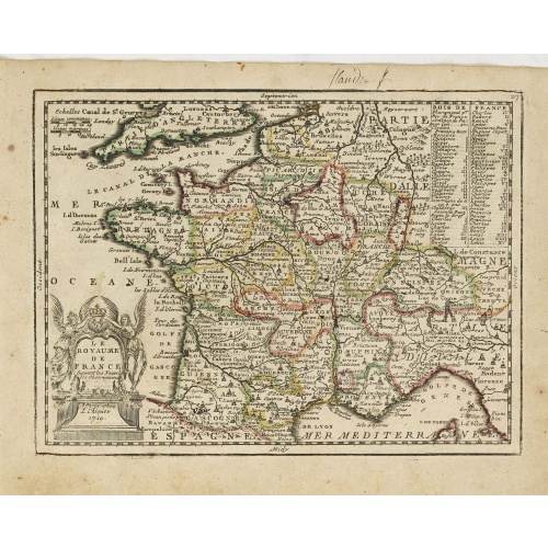
Le Royaume de France..
BuyNow for €75
- Maker :
- CHIQUET, J.
- Place :
- Paris
- Date :
- 1719
- Color :
- In original outline colors
- Height mm.:
- 163
- Width mm.:
- 222
- Condition :
- A good and dark impression. Paper slightly age-toned.
- Bibliography :
- -
- Seller's ref. :
- 34374
This item is offered by Librairie_Loeb-Larocque
See other Items from this seller- Postage
-
France
€15 to France
- Select Country
- Zip/Post Code
- Quantity
€75
Description
Lovely small map of France with decorative title cartouche and a panel in the upper right corner listing local rulers.From Le Nouveau et Curieux Atlas Geographique et Historique.. by Jacques Chiquet.
Together with an engraved French text sheet entitled Le Royaume de France.
![De Bello Belgico decades duae ab excessu... [including lion map]](/uploads/cache/07603-500x500.jpg)
De Bello Belgico decades duae ab excessu... [including lion map]
Included in Famiani Stradae Romani è Societate Jesu de Bello Belgico Decas duae... .Published by Johann Godfried Martin Schönwetter. The book was first published in 1651 and re-published in 1699. The binding is a fine German blind-tooled pigskin, clamps wanting. Fair amount of pages has the usual browning. Copy is somewhat used but altogether very fine. Specially the folding historical engravings are of a high standard.The Bello Belgico , written by Famianus Strada (1572-1649), Jesuit and teac...
$3.500
Maker : STRADA
Place : Frankfurt am Main, Schönwetter
Date : 1699
![Cordelirs in Franckr. [France].](/uploads/cache/13811-500x500.jpg)
Cordelirs in Franckr. [France].
A panoramic view of the town of Cordelirs (probably imaginary) with in center the church. On the foreground a man hunting a wolve. With a verse in two languages underneath the picture.The poet Daniel Meisner from Komotau started his Thesaurus Philo-Politicus. Das ist Politisches Schatzkästlein guter Herren und bestendiger Freund... in Frankfurt in 1623, initially in parts, each one containing about fifty plans. The work was printed work and was printed by Eberhard Kieser. In 1678 the collection...
€60
Maker : MEISNER, D.
Place : Frankfurt
Date : 1623-1678
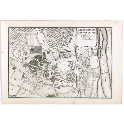
Plan general des chateaux et ville de St Germain en Laye.
City plan of St Germain en Laye, from Nicolas de Fer's "L'Atlas curieux ou le Monde réprésente dans des cartes. "The "Atlas Curieux" is a geographic encyclopedia of images and a celebration of the French Empire under the Sun King, with maps of French possessions in the western hemisphere, maps of France, with detailed views of the grand waterworks at Marly, views of the great palaces and chateaux, views and plans of the Paris Observatory, and samples of military architecture. Issued in six ann...
€60
Maker : DE FER, N.
Place : Paris
Date : 1705
Postage & Shipping
-
Item Location
Terms and conditions - Item Location
- 75013, Ile-de-France, France
- Ships To
- United States, United Kingdom, Albania, Argentina, Armenia, Australia, Austria, Bahamas, Belgium, Bermuda, Bosnia and Herzegowina, Brazil, Bulgaria, Canada, Chile, China, Costa Rica, Denmark, Dominica, Egypt, El Salvador, Finland, France, Germany, Greece, Guatemala, Hong Kong, Hungary, Iceland, India, Italy, Japan, Korea (South), Kuwait, Liechtenstein, Lithuania, Luxembourg, Madagascar, Mexico, Monaco, Morocco, Netherlands, Netherlands Antilles, New Zealand, Norway, Paraguay, Peru, Philippines, Poland, Portugal, Qatar, Reunion, Romania, San Marino, Saudi Arabia, Seychelles, Singapore, Slovenia, South Africa, Spain, Sri Lanka, Suriname, Sweden, Switzerland, Taiwan, Thailand, Tunisia, Turkey, United Arab Emirates, Uruguay, Vietnam
- Pick-ups
- Buyer can pick-up
This item is owned and offered by the seller Librairie_Loeb-Larocque - All items are available for immediate sale, offered subject to prior sale.
Invoices are created by the seller by using our shopping cart or be prepared by the seller the day following the order and are emailed to you.
Items offeres by different sellers are invoiced separately.
Shipping fees are extra. The buyer is responsible for all applicable taxes, including any VAT, customs clearance, import duties, or equivalent costs arriving at the customer's home border. Payment is due on receipt of the invoice. The item(s) are shipped as soon as possible after receipt of your payment.
Before buying please read the complete Terms Conditions of Sale.
- Payment Methods
- Visa, Mastercard, Bank Transfer, American Express, iDEAL, PayPal, Google Pay
- Returns Accepted
- No
Post Message
Feel free to ask the seller a question. Please note that the seller could be located in an area with a different time zone. Our seller will do their best to respond within 24 hours.Post your message below.
Sign in to ask the seller a question.