
ID: 417
Open
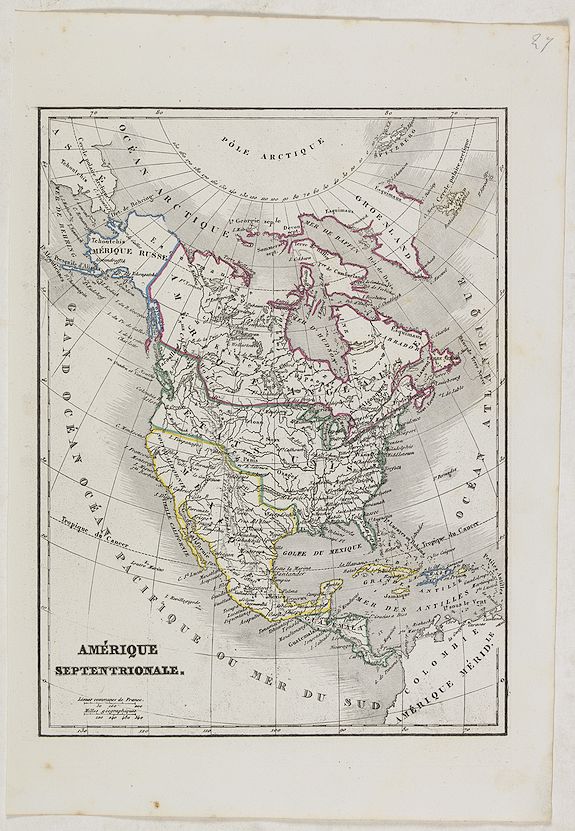
Amérique Septentrionale.
BuyNow for €50
- Maker :
- MONIN, C.V.
- Place :
- Paris
- Date :
- 1845
- Color :
- In original outline colors
- Height mm.:
- 260
- Width mm.:
- 195
- Condition :
- Steel engraving in original out line colors. Good margins. In good condition.
- Bibliography :
- -
- Seller's ref. :
- 44474
This item is offered by Librairie_Loeb-Larocque
See other Items from this seller- Postage
-
France
€15 to France
- Select Country
- Zip/Post Code
- Quantity
€50
Description
Detailed map of America, prepared by Charles V. Monin (fl.1830-1880) a French cartographer of Caen and Paris. Published in Atlas Universel de Géographie Ancienne &c Moderne en 42 Cartes dressé par C.V. Monin. Engraved by Laguillermie.![[Les anciennes provinces Françaises à la ville de Saint Denis].](/uploads/cache/41684-500x500.jpg)
[Les anciennes provinces Françaises à la ville de Saint Denis].
Nine small chromolithography's trade cards for Ville de Saint Denis, each with French regions and places, with description in French on each verso.Cards of the regions : Bearn, Berry, Le Bourbonnais, Roussillon, Comté de Foix, Nivernais, Corse, Marche and L'Aunis.
€75
Maker : H. LAAS & PECAUD & CIE PARIS
Place : Paris
Date : circa 1900
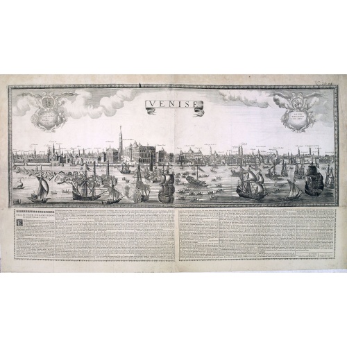
Venise. 1700
Extremely rare panoramic broad sheet panoramic town-view of Venice with underneath in letter press a description of the town's history.The view measures more than 1 meter. The foreground is animated with a great variety of sailing vessels.The printer's address is dated 1699, but the tile has the date 1700. Most likely, Jaillot published the view to celebrate the turn of the century!
€20.000
Maker : JAILLOT, H.
Place : Paris
Date : 1699
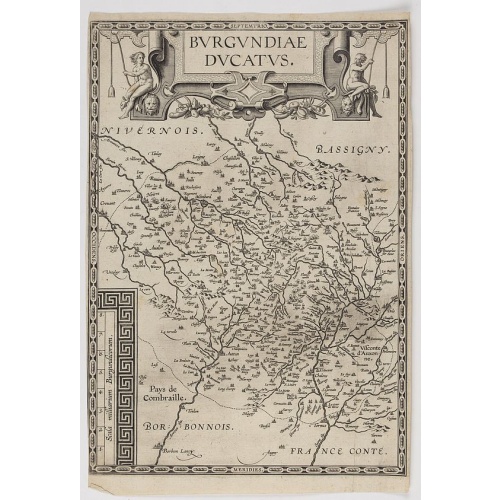
Burgundiae Ducatus.
Map of Burgundy region without text on the verso. Second state with the date 1597 removed from the title cartouche. This is the rarest Burgundy map of the four that Ortelius made.
€500
Maker : ORTELIUS, A.
Place : Antwerp
Date : after 1612
-500x500.jpg)
Carte de la Guyane Françoise et l'Isle de Cayenne..
A well engraved and highly detailed chart of French Guiana and the island of Cayenne. Made in 1763 by Jacques Bellin (1703-72), a prolific cartographer assigned the Ministry of the French Navy. It shows soundings, anchorage's, channels, shoals, navigational sightings. Engraved by Croisey, engraver for the Depot Générale de la marine is noted as such on the map.
€500
Maker : BELLIN, J. N.
Place : Paris
Date : 1763
Postage & Shipping
-
Item Location
Terms and conditions - Item Location
- 75013, Ile-de-France, France
- Ships To
- United States, United Kingdom, Albania, Argentina, Armenia, Australia, Austria, Bahamas, Belgium, Bermuda, Bosnia and Herzegowina, Brazil, Bulgaria, Canada, Chile, China, Costa Rica, Denmark, Dominica, Egypt, El Salvador, Finland, France, Germany, Greece, Guatemala, Hong Kong, Hungary, Iceland, India, Italy, Japan, Korea (South), Kuwait, Liechtenstein, Lithuania, Luxembourg, Madagascar, Mexico, Monaco, Morocco, Netherlands, Netherlands Antilles, New Zealand, Norway, Paraguay, Peru, Philippines, Poland, Portugal, Qatar, Reunion, Romania, San Marino, Saudi Arabia, Seychelles, Singapore, Slovenia, South Africa, Spain, Sri Lanka, Suriname, Sweden, Switzerland, Taiwan, Thailand, Tunisia, Turkey, United Arab Emirates, Uruguay, Vietnam
- Pick-ups
- Buyer can pick-up
This item is owned and offered by the seller Librairie_Loeb-Larocque - All items are available for immediate sale, offered subject to prior sale.
Invoices are created by the seller by using our shopping cart or be prepared by the seller the day following the order and are emailed to you.
Items offeres by different sellers are invoiced separately.
Shipping fees are extra. The buyer is responsible for all applicable taxes, including any VAT, customs clearance, import duties, or equivalent costs arriving at the customer's home border. Payment is due on receipt of the invoice. The item(s) are shipped as soon as possible after receipt of your payment.
Before buying please read the complete Terms Conditions of Sale.
- Payment Methods
- Visa, Mastercard, Bank Transfer, American Express, iDEAL, PayPal, Google Pay
- Returns Accepted
- No
Post Message
Feel free to ask the seller a question. Please note that the seller could be located in an area with a different time zone. Our seller will do their best to respond within 24 hours.Post your message below.
Sign in to ask the seller a question.

![[Religious ritual on Hispaniola].](/uploads/cache/39921-500x500.jpg)