ID: 338
Open
Listing ID: #358 has been added to your wishlist.
Listing ID: #401 has been added to your wishlist.
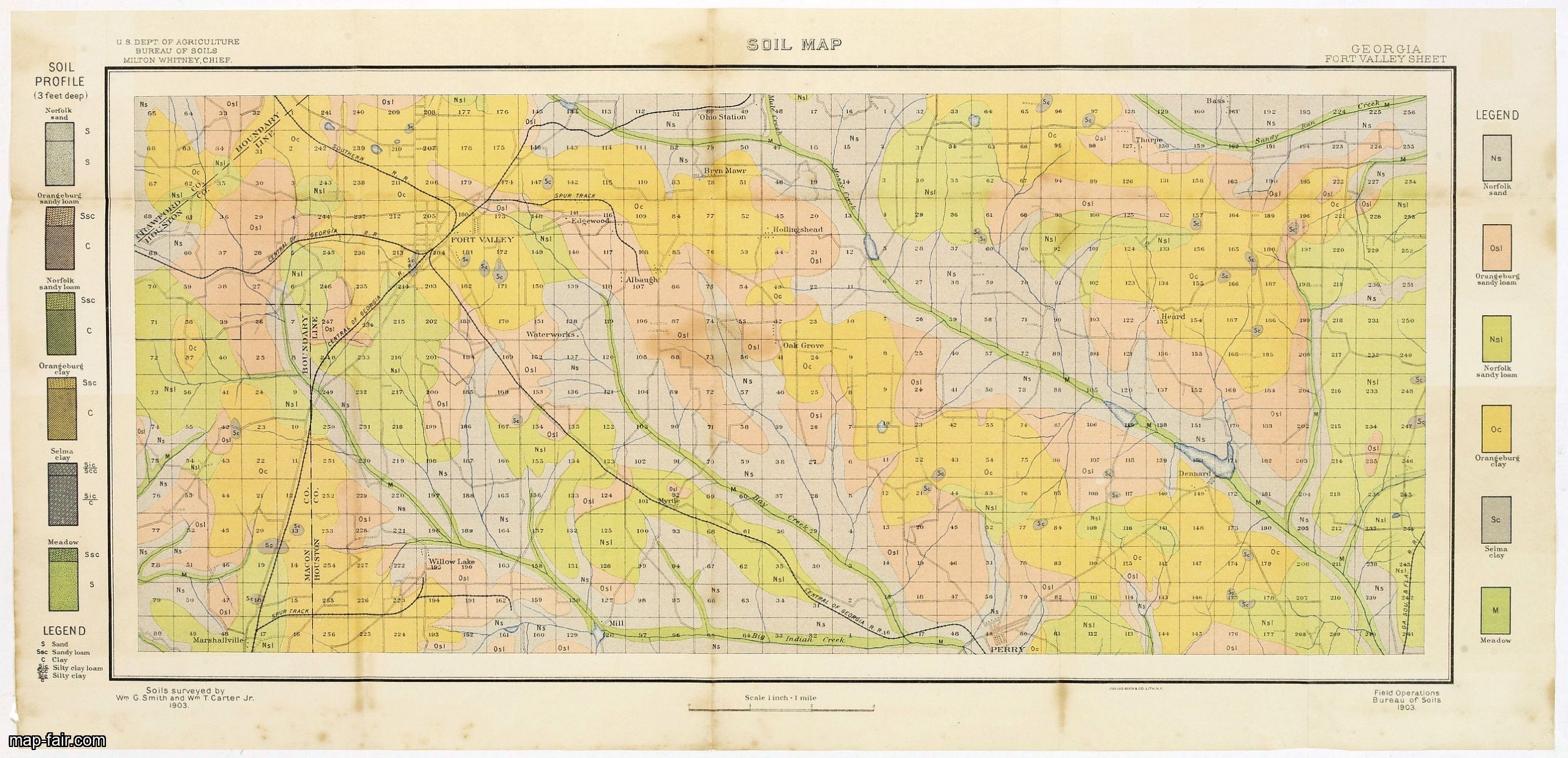
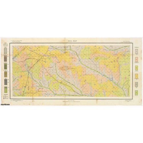
Soil map - Georgia, Fort Valley sheet.
BuyNow for $50
- Maker :
- U.S. DEPT. OF ARGICULTURE
- Place :
- New York, 1903
- Date :
- 1903
- Color :
- Color-printed
- Height mm.:
- 275
- Width mm.:
- 607
- Condition :
- Lithography in 6 colors. Folded as issued. Some light spotting along part of the folds and in the margins. Else good condition.
- Bibliography :
- -
- Seller's ref. :
- 23268
This item is offered by Paulus_Swaen_Old_Maps
See other Items from this seller- Postage
-
Europe
$34 to France
- Select Country
- Zip/Post Code
- Quantity
$50
Description
Early color lithographed soil map by Julius Bien & Co. in New York for Department of Agriculture.
Legends at side give detail on soil type, etc. They also include interesting details of the cities, roads, railroads, rivers, canals, etc. Scale of 1" = 1 mile.
The map is giving great detail of the area in the year 1903. Soils are surveyed by Wm. G. Smith and Wm. T. Carter Jr. in the same year. To the left and right color keys to the different types of soil.
Upper left: U.S.Department of Agriculture, Bureau of soils, Milton Whitney, Chief. Short legend in the lower left corner.
Julies Bien (later Bien & Co) was born and educated in Germany, and moved to America in 1849. He started his business as an engraver and lithographer, later trading as a publisher. He built up a leading map making establishment employing more than two hundred people and several lithographic and copperplate presses. Worked extensively for US Government.
THESE MAPS ARE USEFUL IN THE SEARCH FOR ROCKS, MINERALS AND FOSSILS.

Nieuwe Wassende Graade Zee Kaart over de Spaanse Zee Vant Kanaal tot 't Eyland Cuba in Westindia. . .
¤ Engraved by I.van Anse. A very representative example of a Dutch chart of the Atlantic, showing the north-east coast of America, the coasts of Africa and Europe and South America, including Florida and the West Indies. Gerard issued ca. 40 charts of this exceptionally large format. Collections of these large-size charts were issued in the shining sea-torch and as separate atlases.Title in Dutch, French and English. North America from Labrador to West Florida, including New Foundland, the Gulf...
$3.000
Maker : VAN KEULEN, G.
Place : Amsterdam
Date : 1728

Beschrijvinge vande de zee Cuften va Vlanderen en Picardien. . .
DUTCH TEXT EDITION. A detailed chart of the coast of Flanders and Normandy decorated by a large colorful baroque title cartouche, and the coat of arms of Flanders with a colorful scale cartouche decorated with a compass, a compass rose, several vessels and sea monsters. From an early Dutch text edition of this landmark contribution to the science of navigation. Waghenaer's own personal experiences as a pilot along European coasts were used to compile the Spiegel der Zeevaerdt, the first edition ...
$3.000
Maker : WAGHENAER, L. J.
Place : Leiden, Plantijn
Date : 1585

Marine parallel rulers in brass.
Very fine marine parallel rulers in brass. The parallel ruler is the oldest and most traditional way to measure and trace routes and bearings. The principle is simple: the ruler is placed on the road to be measured and then, like a pantograph, the other part of the ruler is placed on one of the declination roses on the map to determine the angle. They are, essentially, two straight-edges hinged so that they maintain the same angle. By alternating the moving edge, and securely holding down the no...
$1.500
Maker : ANONYMOUS
Place : Paris
Date : ca. 1880
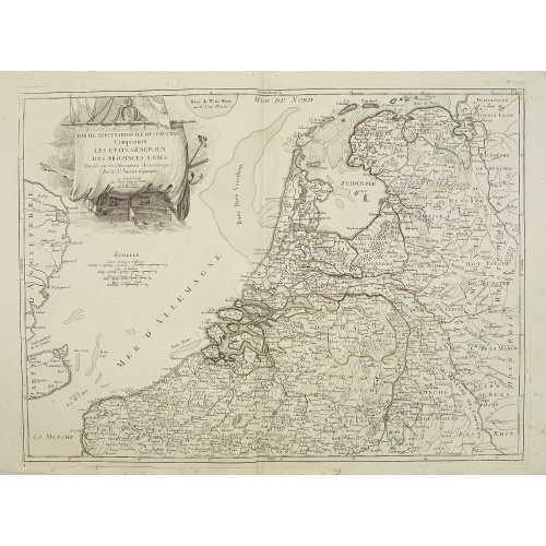
Partie septentrionale des Pays-Bas comprenant .. des provinces unies. . .
Finely and crisply engraved map of Netherlands.Venetian edition of Giles Didier Robert De Vaugondy's map from Atlas Universel printed in 1776-84.Ornamental title cartouche in the upper right corner, including a large vessel in the North Sea.
$450
Maker : SANTINI, P. / REMONDINI, M.
Place : Venice, 1776 - 1784
Date : 1784
Postage & Shipping
-
Item Location
Terms and conditions - Item Location
- 75013, Ile-de-France, France
- Ships To
- United States, United Kingdom, Albania, Argentina, Armenia, Australia, Azerbaijan, Bahamas, Belgium, Bermuda, Cambodia, Canada, Chile, China, Croatia, Cyprus, Czech Republic, Denmark, Estonia, Finland, France, Germany, Gibraltar, Greece, Greenland, Guatemala, Hong Kong, Iceland, India, Indonesia, Israel, Italy, Japan, Latvia, Lithuania, Luxembourg, Malta, Mexico, Monaco, Netherlands, Norway, Singapore, Spain, Sweden, Switzerland, Turkey
- Pick-ups
- No pick-ups
This item is owned and offered by the seller Paulus_Swaen_Old_Maps - All items are available for immediate sale, offered subject to prior sale.
Invoices are created by the seller by using our shopping cart or be prepared by the seller the day following the order and are emailed to you.
Items offeres by different sellers are invoiced separately.
Shipping fees are extra. The buyer is responsible for all applicable taxes, including any VAT, customs clearance, import duties, or equivalent costs arriving at the customer's home border. Payment is due on receipt of the invoice. The item(s) are shipped as soon as possible after receipt of your payment.
Before buying please read the complete Terms Conditions of Sale.
- Payment Methods
- Visa, Mastercard, Bank Transfer, iDEAL, PayPal
- Returns Accepted
- No
Post Message
Feel free to ask the seller a question. Please note that the seller could be located in an area with a different time zone. Our seller will do their best to respond within 24 hours.Post your message below.
Sign in to ask the seller a question.