
ID: 366
Open
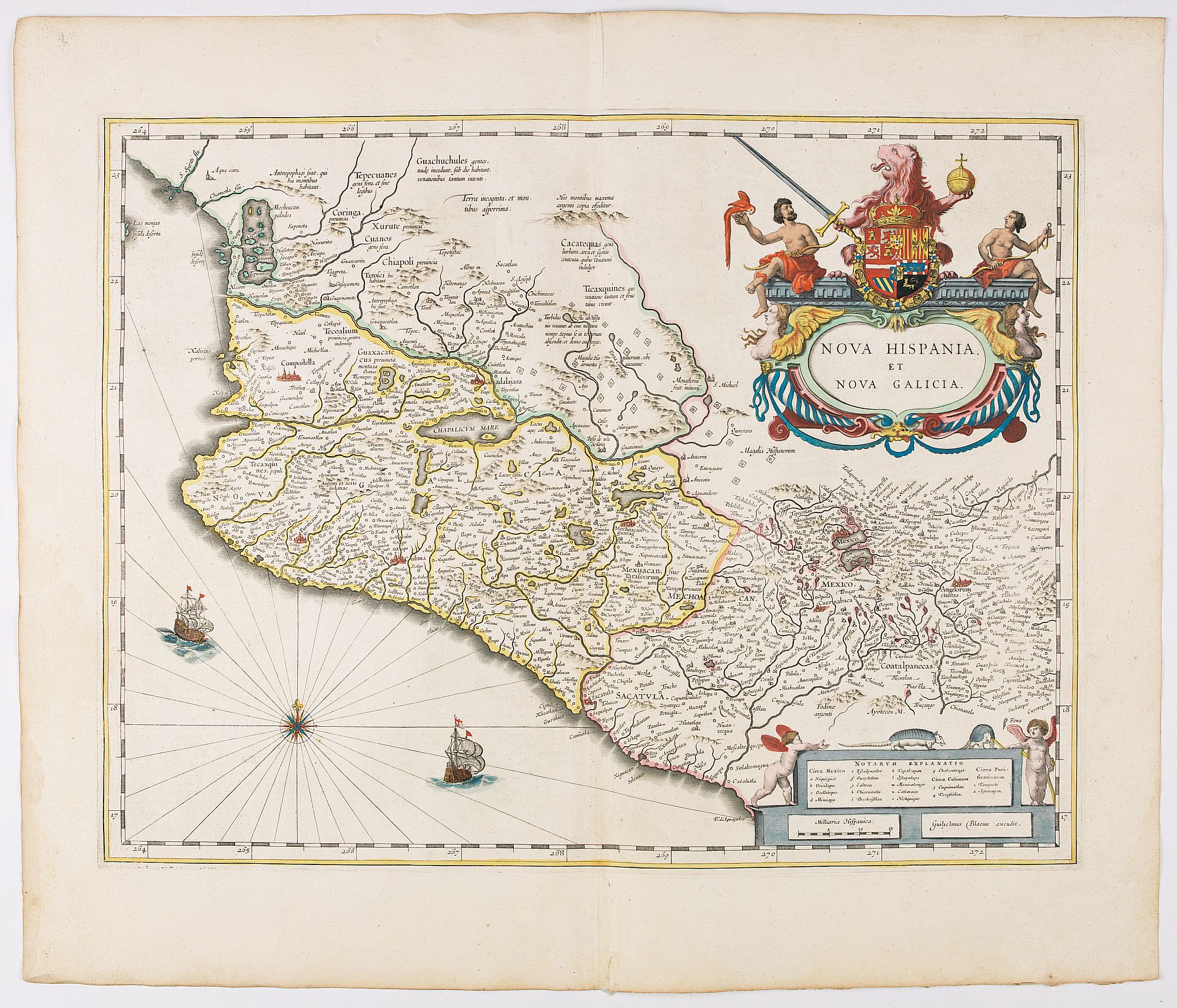
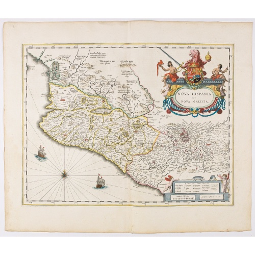
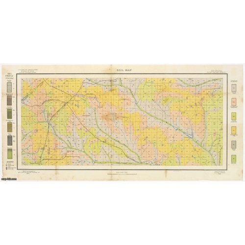
Nova Hispania et Nova Galicia.
BuyNow for €850
- Maker :
- BLAEU, W.
- Place :
- Amsterdam
- Date :
- 1644
- Color :
- In original colors.
- Height mm.:
- 383
- Width mm.:
- 500
- Condition :
- A good and dark impression. Paper creasing along center fold, generally in very good condition. French text on verso.
- Bibliography :
- -
- Seller's ref. :
- 45168
This item is offered by Librairie_Loeb-Larocque
See other Items from this seller- Postage
-
France
€15 to France
- Select Country
- Zip/Post Code
- Quantity
€850
Description
Map of New Spain and New Galicia shows the city of Mexico situated by a large lake, as well as the location of many silver and gold mines. The map's elaborate cartouche is surmounted by the Spanish Royal coat of arms.Based on Ortelius map of 1579 which became the basis for many of the seventeenth century maps of the area.
From early on Willem Jansz. Blaeu aimed of publishing an atlas to compete with the Hondius-Jansson Atlas. By 1630, he had published at least 17 folio size maps.
Blaeu was able to realize his plan soon after he had acquired the copper plates of the atlas maps by Jodocus Hondius. The "Appendix followed in 1630.
In 1635 he finally realized a "international edition" of a world atlas, the "Theatrum Orbis Terrarum".
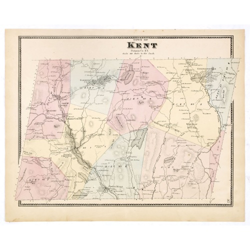
Town of Kent.
Fine lithographed map of the town of Kent. From :"Atlas of New York and vicinity" published by Beers, Ellis & Soule, 95 Maiden Lane, New York.The map provides the names of specific homeowners, as well as information about the occupations and physical locations of the various tradesmen in each village from Beer's famous county atlas "Atlas of New York and vicinity", a documentary record of nineteenth-century life and delightful specimens of American folk art.F. W. Beers, along with other members ...
€90
Maker : DE BEERS, F. W.
Place : New York
Date : 1867

Plan du Port des Francais sur la Cote du Nord-Ouest de l'Amerique, par 58°37' de Latitude Nord et 139°50' de Longitude Occidentale, Decouverte le 2 Juillet 1786,...
Chart of the entrance of Bassin de L'Quest , visited on July 2nd 1786 by La Perouse. On many 18th century maps we find a depiction of Mer de L'Quest or Sea of the West a great sea, easily the size of the Mediterranean, to flow from the then-known Strait of Juan de Fuca and an opening to the ocean from this great sea at roughly in North California or Oregon and Quivira somewhere in Idaho.Engraved by Bouclet.
€500
Maker : LA PEROUSE, J.F.G.
Place : Paris
Date : 1798
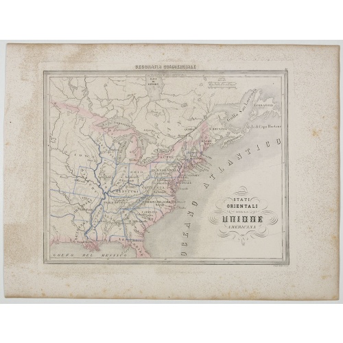
Stati Orientali della Unione Americana.
Uncommon map of Northeastern America prepared by Francesco Costantino Marmocchi. Above the map "Geografia Commerciale". From "Il Globo Atlante di carte Geografiche compilate da F.C. Marmocchi per servire di corredo al suu corso di geografia commerciale", with the maps engraved by engraved by Gius. Cattaneo, Campo Antico, C. Poggiali, G. Bonatti, and Ces. Magrini.Marmocchi (Poggibonsi, 1805-Geneva, 1858) was known as a geographer and cartographer. He emigrated to Rome, and later to Corsica, later...
€50
Maker : MARMOCCHI, F.C.
Place : Genova, Paolo Rivara fu Giacomo
Date : 1858
![Cordelirs in Franckr. [France].](/uploads/cache/13811-500x500.jpg)
Cordelirs in Franckr. [France].
A panoramic view of the town of Cordelirs (probably imaginary) with in center the church. On the foreground a man hunting a wolve. With a verse in two languages underneath the picture.The poet Daniel Meisner from Komotau started his Thesaurus Philo-Politicus. Das ist Politisches Schatzkästlein guter Herren und bestendiger Freund... in Frankfurt in 1623, initially in parts, each one containing about fifty plans. The work was printed work and was printed by Eberhard Kieser. In 1678 the collection...
€60
Maker : MEISNER, D.
Place : Frankfurt
Date : 1623-1678
Postage & Shipping
-
Item Location
Terms and conditions - Item Location
- 75013, Ile-de-France, France
- Ships To
- United States, United Kingdom, Albania, Argentina, Armenia, Australia, Austria, Bahamas, Belgium, Bermuda, Bosnia and Herzegowina, Brazil, Bulgaria, Canada, Chile, China, Costa Rica, Denmark, Dominica, Egypt, El Salvador, Finland, France, Germany, Greece, Guatemala, Hong Kong, Hungary, Iceland, India, Italy, Japan, Korea (South), Kuwait, Liechtenstein, Lithuania, Luxembourg, Madagascar, Mexico, Monaco, Morocco, Netherlands, Netherlands Antilles, New Zealand, Norway, Paraguay, Peru, Philippines, Poland, Portugal, Qatar, Reunion, Romania, San Marino, Saudi Arabia, Seychelles, Singapore, Slovenia, South Africa, Spain, Sri Lanka, Suriname, Sweden, Switzerland, Taiwan, Thailand, Tunisia, Turkey, United Arab Emirates, Uruguay, Vietnam
- Pick-ups
- No pick-ups
This item is owned and offered by the seller Librairie_Loeb-Larocque - All items are available for immediate sale, offered subject to prior sale.
Invoices are created by the seller by using our shopping cart or be prepared by the seller the day following the order and are emailed to you.
Items offeres by different sellers are invoiced separately.
Shipping fees are extra. The buyer is responsible for all applicable taxes, including any VAT, customs clearance, import duties, or equivalent costs arriving at the customer's home border. Payment is due on receipt of the invoice. The item(s) are shipped as soon as possible after receipt of your payment.
Before buying please read the complete Terms Conditions of Sale.
- Payment Methods
- Visa, Mastercard, Bank Transfer, American Express, iDEAL, PayPal, Google Pay
- Returns Accepted
- No
Post Message
Feel free to ask the seller a question. Please note that the seller could be located in an area with a different time zone. Our seller will do their best to respond within 24 hours.Post your message below.
Sign in to ask the seller a question.
![[Religious ritual on Hispaniola].](/uploads/cache/39921-500x500.jpg)
