
ID: 348
Open
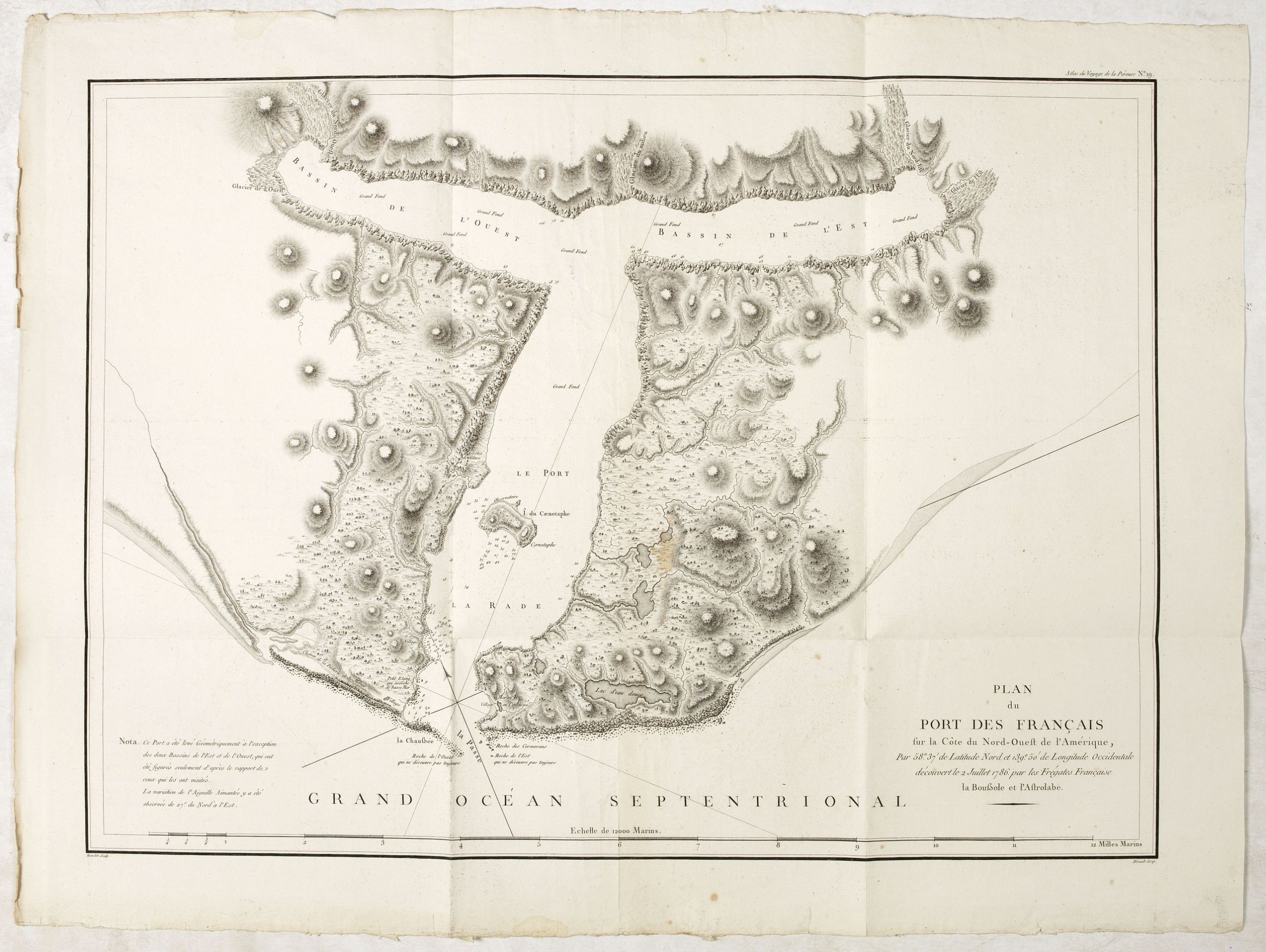
Plan du Port des Francais sur la Cote du Nord-Ouest de l'Amerique, par 58°37' de Latitude Nord et 139°50' de Longitude Occidentale, Decouverte le 2 Juillet 1786,...
BuyNow for €500
- Maker :
- LA PEROUSE, J.F.G.
- Place :
- Paris
- Date :
- 1798
- Color :
- Uncoloured
- Height mm.:
- 498
- Width mm.:
- 683
- Condition :
- Several folds as issued. Paper slightly age-toned. Wide margins.
- Bibliography :
- -
- Seller's ref. :
- 08575
This item is offered by Librairie_Loeb-Larocque
See other Items from this seller- Postage
-
France
€15 to France
- Select Country
- Zip/Post Code
- Quantity
€500
Description
Chart of the entrance of Bassin de L'Quest , visited on July 2nd 1786 by La Perouse. On many 18th century maps we find a depiction of Mer de L'Quest or Sea of the West a great sea, easily the size of the Mediterranean, to flow from the then-known Strait of Juan de Fuca and an opening to the ocean from this great sea at roughly in North California or Oregon and Quivira somewhere in Idaho.
Engraved by Bouclet.
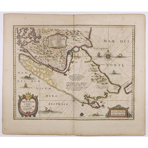
Freti Magellanici ac novi Freti vulgo Le Maire. . .
A fine map of Tierra del Fuego. With an explanatory text of the passage by Barent Jansz. Potgieter who accompanied captain Sebald de Weert to the Straits in 1599/1600, being the first Dutch vessels to sail through the Strait of Magellan, in Latin and Dutch.After various English voyages, the Dutch appeared in the Strait of Magellan in 1599. One of the Dutch pioneering voyages to the Southwest was the one by Jacques Mahu and Simon de Cordes, who were sent out by Rotterdam merchants. The five ships...
€800
Maker : HONDIUS, H.
Place : Amsterdam
Date : ca. 1633

West India Islands.
Map of the West Indies, published by "The London Printing and Publishing Company". Drawn and engraved by John Rapkin.
€75
Maker : RAPKIN, J.
Place : London
Date : 1854
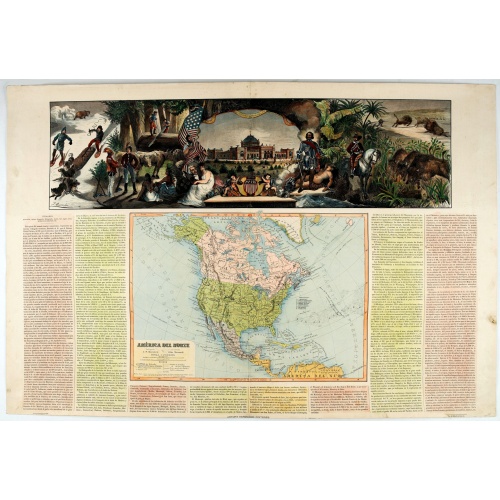
América del Norte.
Very attractive large map of North America with stunning panorama at top of figures representing the continents, etc. A rare and decorative map. From "Atlas geográfico universal texto redactado bajo la dirección de Dr. D. Juan Vilanova parte artística bajo la dirección de Otto Neussel Dibº geogrº J.P. Morales, cromo litogrº Ginés Ruiz".Good hand color on panorama and original lithographic color on the map. The most ambitious of all the monographs and scientific works by Spanish geographe...
€550
Maker : ASTORT HERMANOS EDITORES
Place : Madrid
Date : 1877

Europa recens descripta à Guilielmo Blaeuw.
On either side columns depicting the manner of dress in the major countries of Europe, surmounted by nine city views and plans.For European mapmakers their own continent contained few mysteries or secrets by the seventeenth century. However, the mythical island of Frisland still appears between Iceland and Greenland. The map is decorated with ships and a sea monster on the sea, bears on northern Russia, and lions on North Africa.
€3.250
Maker : BLAEU, W.
Place : Amsterdam
Date : 1644
Postage & Shipping
-
Item Location
Terms and conditions - Item Location
- Paris, Ile-de-France, France
- Ships To
- United States, United Kingdom, Albania, Argentina, Armenia, Australia, Austria, Bahamas, Belgium, Bermuda, Bosnia and Herzegowina, Brazil, Bulgaria, Canada, Chile, China, Costa Rica, Denmark, Dominica, Egypt, El Salvador, Finland, France, Germany, Greece, Guatemala, Hong Kong, Hungary, Iceland, India, Italy, Japan, Korea (South), Kuwait, Liechtenstein, Lithuania, Luxembourg, Madagascar, Mexico, Monaco, Morocco, Netherlands, Netherlands Antilles, New Zealand, Norway, Paraguay, Peru, Philippines, Poland, Portugal, Qatar, Reunion, Romania, San Marino, Saudi Arabia, Seychelles, Singapore, Slovenia, South Africa, Spain, Sri Lanka, Suriname, Sweden, Switzerland, Taiwan, Thailand, Tunisia, Turkey, United Arab Emirates, Uruguay, Vietnam
- Pick-ups
- No pick-ups
This item is owned and offered by the seller Librairie_Loeb-Larocque - All items are available for immediate sale, offered subject to prior sale.
Invoices are created by the seller by using our shopping cart or be prepared by the seller the day following the order and are emailed to you.
Items offeres by different sellers are invoiced separately.
Shipping fees are extra. The buyer is responsible for all applicable taxes, including any VAT, customs clearance, import duties, or equivalent costs arriving at the customer's home border. Payment is due on receipt of the invoice. The item(s) are shipped as soon as possible after receipt of your payment.
Before buying please read the complete Terms Conditions of Sale.
- Payment Methods
- Visa, Mastercard, Bank Transfer, American Express, iDEAL, PayPal, Google Pay
- Returns Accepted
- No
Post Message
Feel free to ask the seller a question. Please note that the seller could be located in an area with a different time zone. Our seller will do their best to respond within 24 hours.Post your message below.
Sign in to ask the seller a question.
