ID: 379
Open
Listing ID: #379 has been added to your wishlist.
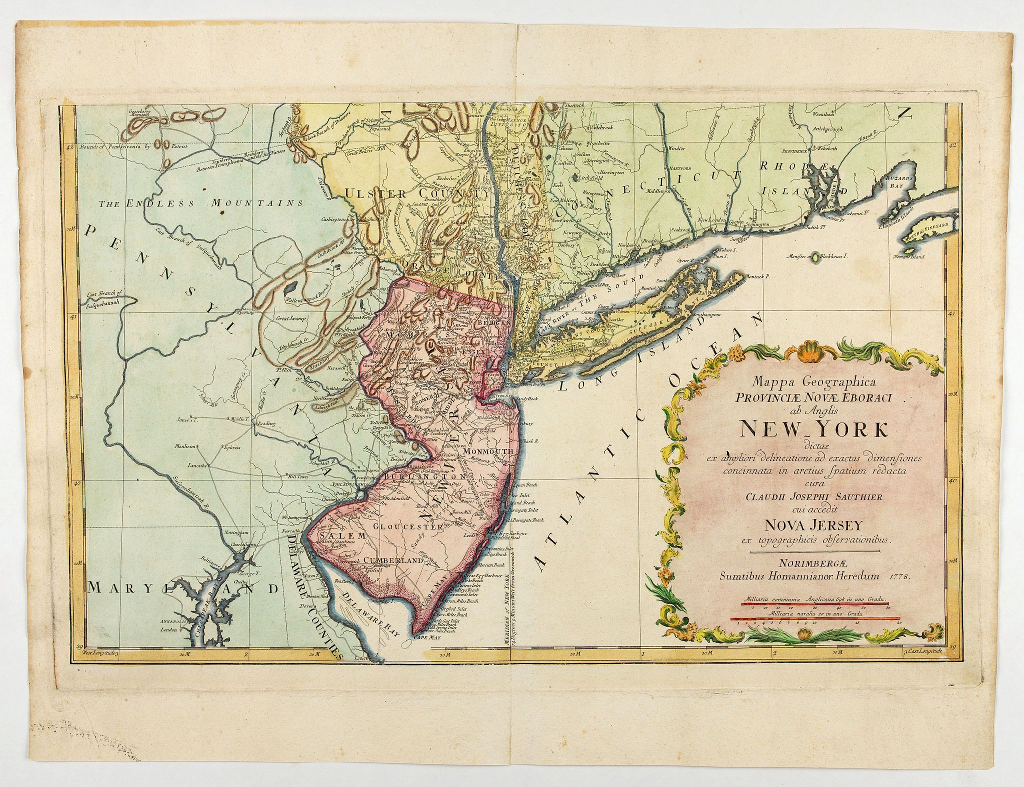
Mappa geographica Provinciæ Nova Eboraci ab Anglis New-York . . .
BuyNow for €750
- Maker :
- HOMANN HEIRS.
- Place :
- Nuremburg
- Date :
- 1778
- Color :
- In original color
- Height mm.:
- 355
- Width mm.:
- 565
- Condition :
- Paper slightly age-toned. Marginal waterstaining. Else in good condition.
- Bibliography :
- -
- Seller's ref. :
- 47576
This item is offered by Librairie_Loeb-Larocque
See other Items from this seller- Postage
-
France
€15 to France
- Select Country
- Zip/Post Code
- Quantity
€750
Description
Lower part of the two sheets map of Homann Heirs' edition of Sauthier's celebrated map of New York and New Jersey, made during the Revolutionary War.

PORTAIL SEPTENTRIONAL DE LA CATHÉDRALE A CHARTRES. Dessiné d'après nature par Monthelier. Lith. par Monthelier.fig. par Bayot.
Original lithograph of the northern portal of Chartres cathedral. Lithographed by Jules Monthelier (1801-1883) and Adolphe-Jean-Baptist Bayot (Alessandria 1810 - 1866) after a design by Chapuy and printed in Paris by Lemercier, Bernard Cie.
€75
Maker : CHAPUY
Place : Paris
Date : 1844
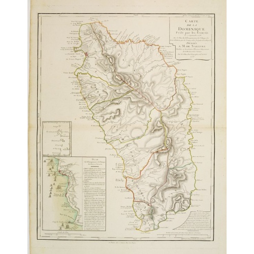
Carte de la Dominique Prise par les Francois le 7 Septembre 1778. Avec le Plan du Debarquement et de l'Attaque des Forts et Batteries par les Troupes et Les Fregates de sa Majeste
A rare map of St. Dominica, with insets of Charlotteville with its attack by the French on 7 September 1778 on the British. Also small inset map of the Caribbean islands from Antigua till Grenada. With dedication to de Sartine, a French official.
€500
Maker : BUACHE, S.
Place : Paris
Date : 1780
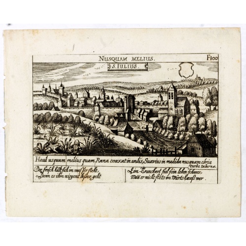
S. Iulius.
A very nice view of the castle of Saint Julius. On the foreground, several frogs are depicted. With a verse in two languages underneath the picture.The poet and topographer from Comothau, Daniel Meisner (1585-1625), started his first publication entitled Thesaurus Philo-Politicus in Frankfurt in 1623, initially in parts, each one containing about fifty plans. The work was engraved circa 1623-1650, and printed 1678, and was published by Eberhard Kieser. In 1678 the collection of copperplates was...
€60
Maker : MEISNER, D.
Place : Frankfurt
Date : 1623-1678
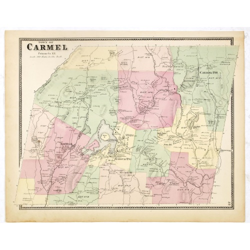
Town of Carmel.
Fine lithographed map of the town of Carmel. From : "Atlas of New York and vicinity" published by Beers, Ellis & Soule, 95 Maiden Lane, New York. The map provides the names of specific homeowners, as well as information about the occupations and physical locations of the various tradesmen in each village from Beer's famous county atlas "Atlas of New York and vicinity," "a documentary record of nineteenth-century life and delightful specimens of American folk art." F. W. Beers, along with other ...
€80
Maker : DE BEERS, F.W.
Place : New York
Date : 1867
Postage & Shipping
-
Item Location
Terms and conditions - Item Location
- 75013, Ile-de-France, France
- Ships To
- United States, United Kingdom, Albania, Argentina, Armenia, Australia, Austria, Bahamas, Belgium, Bermuda, Bosnia and Herzegowina, Brazil, Bulgaria, Canada, Chile, China, Costa Rica, Denmark, Dominica, Egypt, El Salvador, Finland, France, Germany, Greece, Guatemala, Hong Kong, Hungary, Iceland, India, Italy, Japan, Korea (South), Kuwait, Liechtenstein, Lithuania, Luxembourg, Madagascar, Mexico, Monaco, Morocco, Netherlands, Netherlands Antilles, New Zealand, Norway, Paraguay, Peru, Philippines, Poland, Portugal, Qatar, Reunion, Romania, San Marino, Saudi Arabia, Seychelles, Singapore, Slovenia, South Africa, Spain, Sri Lanka, Suriname, Sweden, Switzerland, Taiwan, Thailand, Tunisia, Turkey, United Arab Emirates, Uruguay, Vietnam
- Pick-ups
- No pick-ups
This item is owned and offered by the seller Librairie_Loeb-Larocque - All items are available for immediate sale, offered subject to prior sale.
Invoices are created by the seller by using our shopping cart or be prepared by the seller the day following the order and are emailed to you.
Items offeres by different sellers are invoiced separately.
Shipping fees are extra. The buyer is responsible for all applicable taxes, including any VAT, customs clearance, import duties, or equivalent costs arriving at the customer's home border. Payment is due on receipt of the invoice. The item(s) are shipped as soon as possible after receipt of your payment.
Before buying please read the complete Terms Conditions of Sale.
- Payment Methods
- Visa, Mastercard, Bank Transfer, American Express, iDEAL, PayPal, Google Pay
- Returns Accepted
- No
Post Message
Feel free to ask the seller a question. Please note that the seller could be located in an area with a different time zone. Our seller will do their best to respond within 24 hours.Post your message below.
Sign in to ask the seller a question.