ID: 118
Open
Listing ID: #118 has been added to your wishlist.
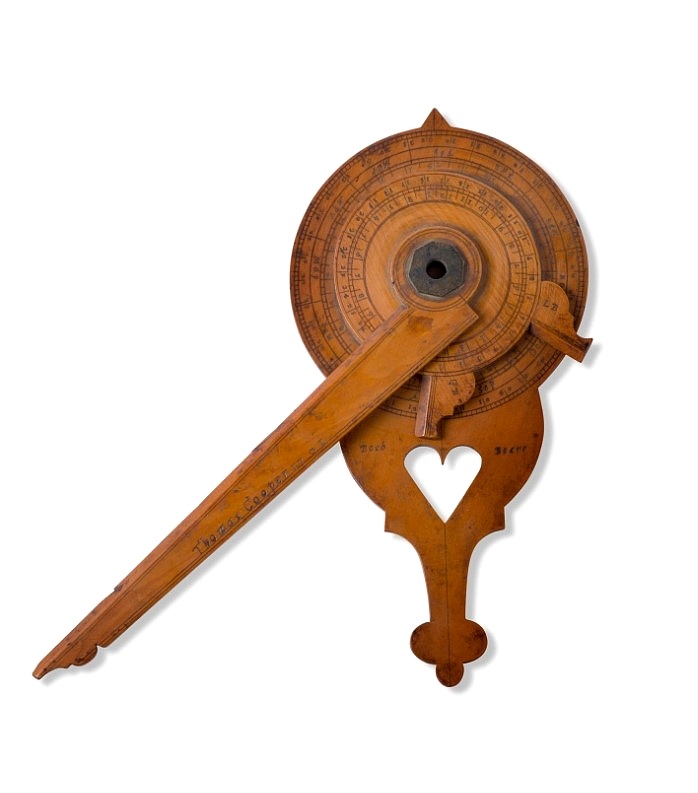
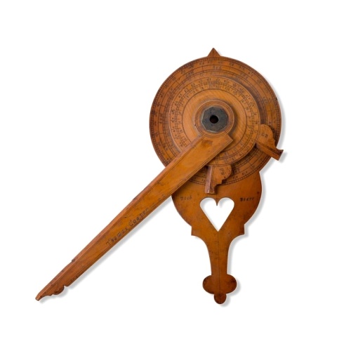
Nocturnal in boxwood and brass.
BuyNow for $15.000
- Maker :
- COOPER, Th.
- Place :
- England, Thomas Cooper
- Date :
- dated 1701
- Color :
- Uncoloured
- Height mm.:
- 205
- Width mm.:
- 260
- Condition :
- In boxwood and brass. Some very minor wear, but generally in very fine condition.
- Bibliography :
- -
- Seller's ref. :
- 48706
This item is offered by Paulus_Swaen_Old_Maps
See other Items from this seller- Postage
-
Standard Shipping
$0 to Netherlands
- Select Country
- Zip/Post Code
- Quantity
$15.000
Description
Nocturlabe in boxwood and brass, the wheels maintained by a central nut presenting an annual calendar divided into months and days, an hour disc and a mobile alidade, the back engraved with a compass rose.The grip is openwork with a heart inscribed "Both Bears" for the Big and Little Dipper.
England, circa 1700.
Height without the alidade : 21,5 cm - Height in total : 26 cm
Nocturnal (sometimes called a ""horologium nocturnum" - time instrument for the night) in boxwood and brass, the wheels held by a central nut presenting an annual calendar divided into months and days, an hour disc and a mobile alidade signed and dated "Thomas Cooper 1701", the back engraved with a compass rose.
The grip is openwork with a heart inscribed "Both Bears" for the Big and Little Dipper.
The Big and Little Dipper.
The Big Dipper is one of the most accessible star patterns located in Earth’s sky. It’s visible just about every clear night in the Northern Hemisphere, looking like a big dot-to-dot of kitchen ladle. As Earth spins, the Big Dipper and its sky neighbor, the Little Dipper, rotate around the North Star, also known as Polaris.
From the northern part of the Northern Hemisphere, the Big and Little Dippers are in the sky continuously. In fact, they are always above your horizon, circling endlessly around Polaris. So given an unobstructed horizon, latitudes north of the 35th parallel (the approximate location of the Mediterranean Sea and Tennessee’s southern border) can expect to see the Big Dipper at any hour of the night every day of the year.
As for the Little Dipper, it’s circumpolar – consistently above the horizon – as far south as the Tropic of Cancer (23.5 degrees north latitude).
Early navigators traversed the open ocean hundreds of years ago using only their eyes and the stars. These first seafarers tracked the movement of stars across the night sky and knew the positions of constellations during every season. Their extensive knowledge of celestial bodies allowed mariners to cross large spans of open water confidently. However, new navigational tools and equipment replaced celestial navigation as civilizations advanced.
The Big Dipper asterism is a famous asterism found in the constellation of Ursa Major. The Little Dipper asterism is located nearby and is a part of the constellation known as Ursa Minor. The Little Dipper is famous for containing the north star, Polaris, which has been utilized for centuries in celestial navigation.
The Big Dipper asterism is a collection of seven stars. It has many names depending on where you live and which point of history you are looking at. Some names include the plow, the wagon, and the saucepan. The list of names for this asterism is exhaustive. But the Big Dipper is part of a larger constellation called Ursa Major.
Using the pointer stars, the Big Dipper can find Polaris, the North Star. If you use the pointer stars and move in this direction, it'll point you toward Leo; you can use the handle of the Dipper to arc to Arcturus and speed to Spica. The Big Dipper is a part of the constellation known as Ursa Major, and Ursa Major is a vast constellation. It's the third largest in the sky and can be seen all year round in the Northern Hemisphere. It can be found in the sky near the Little Dipper asterism.
The Little Dipper
The Little Dipper asterism is a collection of seven stars as well. Three stars are visible with the naked eye, but the remaining four are difficult to see, making this pattern hard to recognize. The Little Dipper and Ursa Minor patterns are the same in shape, which cannot be said about the Big Dipper and Ursa Major. The Big Dipper helps find the Little Dipper because you can use the pointer Stars right here to aim you toward Polaris, which is the North Star and can be found in the Little Dipper.
Polaris is located at the tip of the handle in the Dipper shape. This is an essential star because it points us in the direction of the North, and it's the star that appears to not move in the sky. This is very helpful when it comes to celestial navigation. Polaris is not a bright star in the sky, which is one of the common misconceptions about the North Star. Polaris is the 48th brightest star in the night sky.
-500x500.jpg)
Town of Verplanck / Crugers / Croton Landing.
Fine lithographed map of the town of Verplanck / Crugers / Croton Landing. The map provides the names of specific homeowners, as well as information about the occupations and physical locations of the various tradesmen in each village from Beer's famous county atlas "Atlas of New York and vicinity," "a documentary record of nineteenth-century life and delightful specimens of American folk art." F. W. Beers, along with other members of his family, were among the leading county atlas publishers in...
$90
Maker : DE BEERS, F.W.
Place : New York
Date : 1867

De zee cuften tufschen Dovere en Orfords nesse, daer de Teemse de Vermaerde Rivire van Lonen gelegens is. . .
A detailed chart of the English Channel coastland. Decorated by a colorful title cartouche and scale cartouche, one compass rose, several vessels and sea monsters. A very early edition rare Dutch text edition of this landmark contribution to the science of navigation. Waghenaer's own personal experiences as a pilot along European coasts were used to compile the Spiegel der Zeevaerdt, the first edition of which was published in Dutch at Leyden in 1584/85 by the House of Plantin. Although advertis...
$3.000
Maker : WAGHENAER, L. J.
Place : Leiden, Plantijn
Date : 1585
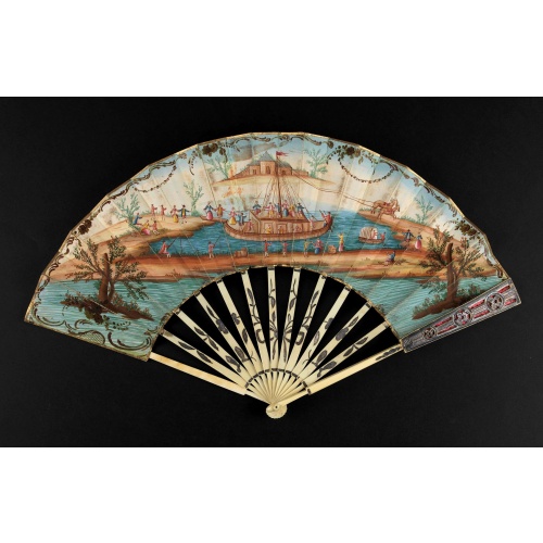
A folding fan showing a nautical festival, ca. 1770.
Folded fan, painted in gouache a ship pulled by two horses. On board, a large company, among others joins them while fishermen watch the scene.Reverse painted with an exotic flower. Monogram "SK" on the left.The ivory frame is engraved with flowers enhanced with silver foil.
$1.500
Maker : ANONYMOUS
Place : France
Date : ca. 1770
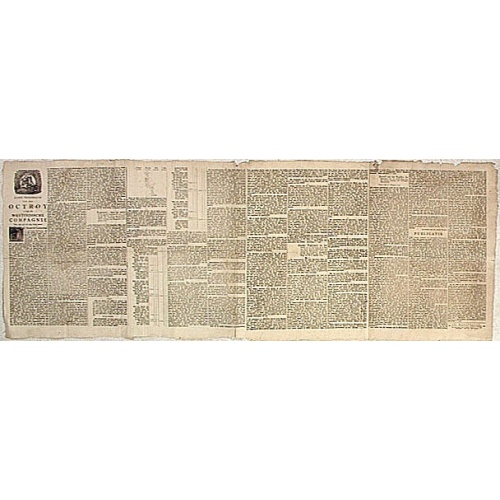
Nader prolongatie van het Octroy voor de Westindische Compagnie voor den tyd van nog dertig jaaren. . .
A proclamation by the Dutch States General, dated 1761, extending the charter of the Dutch West India Company for another thirty years. Like the 1730 proclamation, it has detailed information about the import of slaves from West Africa to Surinam, Essequibo and Berbice, where the WIC was granted a monopoly in the slave trade, while others could import slaves to Curaçao and other parts of America, as the proclamation notes.
$1.500
Maker : SCHELTUS, I.
Place : Amsterdam
Date : 1761
Postage & Shipping
-
Item Location
Terms and conditions - Item Location
- Paris, Ile-de-France, France
- Ships To
- United States, United Kingdom, Albania, Argentina, Armenia, Australia, Azerbaijan, Bahamas, Belgium, Bermuda, Cambodia, Canada, Chile, China, Croatia, Cyprus, Czech Republic, Denmark, Estonia, Finland, France, Germany, Gibraltar, Greece, Greenland, Guatemala, Hong Kong, Iceland, India, Indonesia, Israel, Italy, Japan, Latvia, Lithuania, Luxembourg, Malta, Mexico, Monaco, Netherlands, Norway, Singapore, Spain, Sweden, Switzerland, Turkey
- Pick-ups
- No pick-ups
This item is owned and offered by the seller Paulus_Swaen_Old_Maps - All items are available for immediate sale, offered subject to prior sale.
Invoices are created by the seller by using our shopping cart or be prepared by the seller the day following the order and are emailed to you.
Items offeres by different sellers are invoiced separately.
Shipping fees are extra. The buyer is responsible for all applicable taxes, including any VAT, customs clearance, import duties, or equivalent costs arriving at the customer's home border. Payment is due on receipt of the invoice. The item(s) are shipped as soon as possible after receipt of your payment.
Before buying please read the complete Terms Conditions of Sale.
- Payment Methods
- Visa, Mastercard, Bank Transfer, American Express, iDEAL, PayPal
- Returns Accepted
- No
Post Message
Feel free to ask the seller a question. Please note that the seller could be located in an area with a different time zone. Our seller will do their best to respond within 24 hours.Post your message below.
Sign in to ask the seller a question.