
ID: 151
Open
Listing ID: #151 has been added to your wishlist.


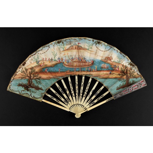
A folding fan showing a nautical festival, ca. 1770.
BuyNow for $1.500
- Maker :
- ANONYMOUS
- Place :
- France
- Date :
- ca. 1770
- Color :
- In original color
- Height mm.:
- 275
- Width mm.:
- 280
- Condition :
- Folding fan. Ivory frame with gold decoration with double sheets of paper with gouache painting. Some usual wear and small restorations.
- Bibliography :
- -
- Seller's ref. :
- 46662
This item is offered by Paulus_Swaen_Old_Maps
See other Items from this seller- Postage
-
Standard Shipping
$0 to Netherlands
- Select Country
- Zip/Post Code
- Quantity
$1.500
Description
Folded fan, painted in gouache a ship pulled by two horses. On board, a large company, among others joins them while fishermen watch the scene.Reverse painted with an exotic flower. Monogram "SK" on the left.
The ivory frame is engraved with flowers enhanced with silver foil.
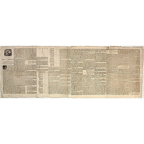
Nader prolongatie van het Octroy voor de Westindische Compagnie voor den tyd van nog dertig jaaren. . .
A proclamation by the Dutch States General, dated 1761, extending the charter of the Dutch West India Company for another thirty years. Like the 1730 proclamation, it has detailed information about the import of slaves from West Africa to Surinam, Essequibo and Berbice, where the WIC was granted a monopoly in the slave trade, while others could import slaves to Curaçao and other parts of America, as the proclamation notes.
$1.500
Maker : SCHELTUS, I.
Place : Amsterdam
Date : 1761
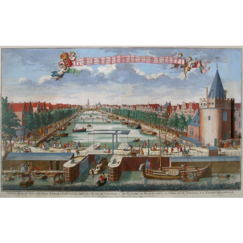
Beschrijving Gezicht van den Ykant af bezyden den Schreiers hoex Toren langs de Keulsche en Geldersche Kaei naer de Nieuwe Markt
This large engraving (560x920mm.) comes from a are series of 25 beautiful large views of Amsterdam and gives a colorful picture of the life and business of the city at the beginning of the 18th century. The print gives a view of the cityscape and architecture of that time. It also shows daily manners and customs and all kinds of scenes take place; There is a fight to the left of the bridge in the foreground (now Prins Hendrik Kade), while in front of the Scheierstoren quiet citizens read the not...
$2.000
Maker : DE LETH, H.
Place : Amsterdam
Date : ca 1720

Mappe-Monde pour connoitre les progres & les conquestes..
Unusual double hemisphere map with California as an Island. Dutch text describes the expeditions and colonial possessions of the Dutch East India Company. The map originated in about 1670. Chatelain acquired the plate; he added decorative elements, including sailing ships, the Dutch crest, and a figure representing Europa seated inside a native fort.Zacharie Chatelain (d.1723) was the father of Henri Abraham (1684-1743) and Zacharie Junior (1690-1754).They worked as a partnership publishing the ...
$800
Maker : CHATELAIN, H.
Place : Amsterdam
Date : 1729
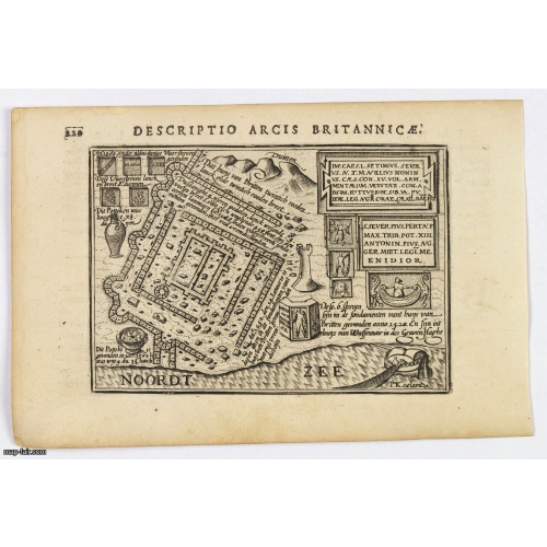
Descriptio Arcis Britannicae.
An original early 17th century copper engraved miniature antique map of the Roman remains in the sand dunes near Katwijk aan Zee in south Holland by Petrus Bertius. In Roman times, Katwijk was a place of strategic importance. It was located at the Roman Empire's northern border, at the mouth of the Rhine river, which in Roman times was larger in this area than it is today. There was a good deal of traffic along the Rhine. Katwijk was also a jumping-off point for the voyage to Britain. The map i...
$100
Maker : LANGENES, B. / BERTIUS, P.
Place : Amsterdam
Date : 1606
Postage & Shipping
-
Item Location
Terms and conditions - Item Location
- 75013, Ile-de-France, France
- Ships To
- United States, United Kingdom, Albania, Argentina, Armenia, Australia, Azerbaijan, Bahamas, Belgium, Bermuda, Cambodia, Canada, Chile, China, Croatia, Cyprus, Czech Republic, Denmark, Estonia, Finland, France, Germany, Gibraltar, Greece, Greenland, Guatemala, Hong Kong, Iceland, India, Indonesia, Israel, Italy, Japan, Latvia, Lithuania, Luxembourg, Malta, Mexico, Monaco, Netherlands, Norway, Singapore, Spain, Sweden, Switzerland, Turkey
- Pick-ups
- No pick-ups
This item is owned and offered by the seller Paulus_Swaen_Old_Maps - All items are available for immediate sale, offered subject to prior sale.
Invoices are created by the seller by using our shopping cart or be prepared by the seller the day following the order and are emailed to you.
Items offeres by different sellers are invoiced separately.
Shipping fees are extra. The buyer is responsible for all applicable taxes, including any VAT, customs clearance, import duties, or equivalent costs arriving at the customer's home border. Payment is due on receipt of the invoice. The item(s) are shipped as soon as possible after receipt of your payment.
Before buying please read the complete Terms Conditions of Sale.
- Payment Methods
- Visa, Mastercard, Bank Transfer, American Express, iDEAL, PayPal, Google Pay
- Returns Accepted
- No
Post Message
Feel free to ask the seller a question. Please note that the seller could be located in an area with a different time zone. Our seller will do their best to respond within 24 hours.Post your message below.
Sign in to ask the seller a question.
![Carte generale de France. [de l'Europe]](/uploads/cache/38442-500x500.jpg)