
ID: 118
Closed
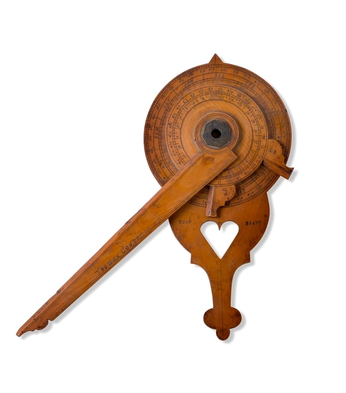
Nocturnal in boxwood and brass.
BuyNow for $15.000
- Maker :
- COOPER, Th.
- Place :
- England, Thomas Cooper
- Date :
- dated 1701
- Color :
- Uncoloured
- Height mm.:
- 205
- Width mm.:
- 260
- Condition :
- In boxwood and brass. Some very minor wear, but generally in very fine condition.
- Bibliography :
- -
- Seller's ref. :
- 48706
This item is offered by Paulus_Swaen_Old_Maps
See other Items from this seller- Postage
-
Standard Shipping
$0 to Netherlands
- Select Country
- Zip/Post Code
- Quantity
$15.000
Description
Nocturlabe in boxwood and brass, the wheels maintained by a central nut presenting an annual calendar divided into months and days, an hour disc and a mobile alidade, the back engraved with a compass rose.The grip is openwork with a heart inscribed "Both Bears" for the Big and Little Dipper.
England, circa 1700.
Height without the alidade : 21,5 cm - Height in total : 26 cm
Nocturnal (sometimes called a ""horologium nocturnum" - time instrument for the night) in boxwood and brass, the wheels held by a central nut presenting an annual calendar divided into months and days, an hour disc and a mobile alidade signed and dated "Thomas Cooper 1701", the back engraved with a compass rose.
The grip is openwork with a heart inscribed "Both Bears" for the Big and Little Dipper.
The Big and Little Dipper.
The Big Dipper is one of the most accessible star patterns located in Earth’s sky. It’s visible just about every clear night in the Northern Hemisphere, looking like a big dot-to-dot of kitchen ladle. As Earth spins, the Big Dipper and its sky neighbor, the Little Dipper, rotate around the North Star, also known as Polaris.
From the northern part of the Northern Hemisphere, the Big and Little Dippers are in the sky continuously. In fact, they are always above your horizon, circling endlessly around Polaris. So given an unobstructed horizon, latitudes north of the 35th parallel (the approximate location of the Mediterranean Sea and Tennessee’s southern border) can expect to see the Big Dipper at any hour of the night every day of the year.
As for the Little Dipper, it’s circumpolar – consistently above the horizon – as far south as the Tropic of Cancer (23.5 degrees north latitude).
Early navigators traversed the open ocean hundreds of years ago using only their eyes and the stars. These first seafarers tracked the movement of stars across the night sky and knew the positions of constellations during every season. Their extensive knowledge of celestial bodies allowed mariners to cross large spans of open water confidently. However, new navigational tools and equipment replaced celestial navigation as civilizations advanced.
The Big Dipper asterism is a famous asterism found in the constellation of Ursa Major. The Little Dipper asterism is located nearby and is a part of the constellation known as Ursa Minor. The Little Dipper is famous for containing the north star, Polaris, which has been utilized for centuries in celestial navigation.
The Big Dipper asterism is a collection of seven stars. It has many names depending on where you live and which point of history you are looking at. Some names include the plow, the wagon, and the saucepan. The list of names for this asterism is exhaustive. But the Big Dipper is part of a larger constellation called Ursa Major.
Using the pointer stars, the Big Dipper can find Polaris, the North Star. If you use the pointer stars and move in this direction, it'll point you toward Leo; you can use the handle of the Dipper to arc to Arcturus and speed to Spica. The Big Dipper is a part of the constellation known as Ursa Major, and Ursa Major is a vast constellation. It's the third largest in the sky and can be seen all year round in the Northern Hemisphere. It can be found in the sky near the Little Dipper asterism.
The Little Dipper
The Little Dipper asterism is a collection of seven stars as well. Three stars are visible with the naked eye, but the remaining four are difficult to see, making this pattern hard to recognize. The Little Dipper and Ursa Minor patterns are the same in shape, which cannot be said about the Big Dipper and Ursa Major. The Big Dipper helps find the Little Dipper because you can use the pointer Stars right here to aim you toward Polaris, which is the North Star and can be found in the Little Dipper.
Polaris is located at the tip of the handle in the Dipper shape. This is an essential star because it points us in the direction of the North, and it's the star that appears to not move in the sky. This is very helpful when it comes to celestial navigation. Polaris is not a bright star in the sky, which is one of the common misconceptions about the North Star. Polaris is the 48th brightest star in the night sky.

Marine parallel rulers in brass.
Very fine marine parallel rulers in brass. The parallel ruler is the oldest and most traditional way to measure and trace routes and bearings. The principle is simple: the ruler is placed on the road to be measured and then, like a pantograph, the other part of the ruler is placed on one of the declination roses on the map to determine the angle. They are, essentially, two straight-edges hinged so that they maintain the same angle. By alternating the moving edge, and securely holding down the no...
$1.500
Maker : ANONYMOUS
Place : Paris
Date : ca. 1880

Mappe-Monde pour connoitre les progres & les conquestes..
Unusual double hemisphere map with California as an Island. Dutch text describes the expeditions and colonial possessions of the Dutch East India Company. The map originated in about 1670. Chatelain acquired the plate; he added decorative elements, including sailing ships, the Dutch crest, and a figure representing Europa seated inside a native fort.Zacharie Chatelain (d.1723) was the father of Henri Abraham (1684-1743) and Zacharie Junior (1690-1754).They worked as a partnership publishing the ...
$800
Maker : CHATELAIN, H.
Place : Amsterdam
Date : 1729

Lyste vande prysen der goederen ingekoft by de Kamer. . .
Rare price list of meat, bacon, wheat, rye, butter, cheese, olive oil, Spanish wines, Bordeaux, brandy etc.On front page in letter press Lyste Van de Pryfen der Goederen, Ingekofst by de Kamer van de OOST-INDISCHE COMPAGNIE tot Gestelt na de datums van der zelver inkoop.Dated in manuscript 1685. Rare pricelist of articles purchased by the V.O.C. over the year 1685. Including large quantities of French wines!. Very rare.
$2.500
Maker : V.O.C.
Place : Amsterdam
Date : 1685

Les Provinces des Pais Bas Autrichiens contenants en XXIV Feuilles les comtées d'Artois, de Flandres, de Hainaut, de Namur et des Duchées de Luxembourg…
Rare wall map of the Catholic of Austrian Low Countries, roughly the southern part of present-day The Netherlands, Belgium and Luxembourg. Map has some large cartouches, ships in the North Sea.
$1.500
Maker : SEUTTER, M.
Place : Augsburg, 1725
Date : 1725
Postage & Shipping
-
Item Location
Terms and conditions - Item Location
- 33765, Florida, United States
- Ships To
- United States, United Kingdom, Albania, Argentina, Armenia, Australia, Azerbaijan, Bahamas, Belgium, Bermuda, Cambodia, Canada, Chile, China, Croatia, Cyprus, Czech Republic, Denmark, Estonia, Finland, France, Germany, Gibraltar, Greece, Greenland, Guatemala, Hong Kong, Iceland, India, Indonesia, Israel, Italy, Japan, Latvia, Lithuania, Luxembourg, Malta, Mexico, Monaco, Netherlands, Norway, Singapore, Spain, Sweden, Switzerland, Turkey
- Pick-ups
- No pick-ups
This item is owned and offered by the seller Paulus_Swaen_Old_Maps - All items are available for immediate sale, offered subject to prior sale.
Invoices are created by the seller by using our shopping cart or be prepared by the seller the day following the order and are emailed to you.
Items offeres by different sellers are invoiced separately.
Shipping fees are extra. The buyer is responsible for all applicable taxes, including any VAT, customs clearance, import duties, or equivalent costs arriving at the customer's home border. Payment is due on receipt of the invoice. The item(s) are shipped as soon as possible after receipt of your payment.
Before buying please read the complete Terms Conditions of Sale.
- Payment Methods
- Visa, Mastercard, Bank Transfer, American Express, iDEAL, PayPal
- Returns Accepted
- No
Post Message
Feel free to ask the seller a question. Please note that the seller could be located in an area with a different time zone. Our seller will do their best to respond within 24 hours.Post your message below.
Sign in to ask the seller a question.
