ID: 342
Open
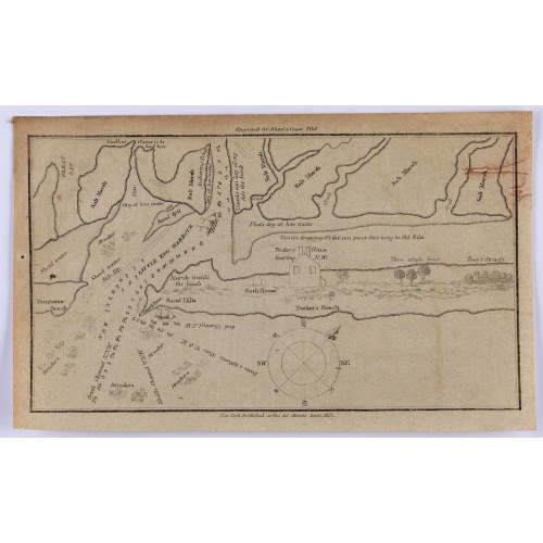
Little Egg Harbour.
BuyNow for $50
- Maker :
- BLUNT, E.
- Place :
- New York, 1817
- Date :
- 1817
- Color :
- Uncolored.
- Height mm.:
- 130
- Width mm.:
- 210
- Condition :
- In good condition with some soiling and general age toning.
- Bibliography :
- -
- Seller's ref. :
- 47248
This item is offered by Paulus_Swaen_Old_Maps
See other Items from this seller- Postage
-
Europe
$34 to France
- Select Country
- Zip/Post Code
- Quantity
$50
Description
A small sea chart showing Little Egg Harbour east of Tucker's Island. This map was published in the “American Coast Pilot”, a detailed guide to harbors, capes and headlands on the east coasts of North and South America.It includes information on winds, currents, tides as well as latitudes and longitudes. The American Coast Pilot was published between 1796 and 1861, until it was replaced by the US Coast Survey.
Edmund March Blunt (1770–1862) was an American navigator, author, and publisher of nautical magazines. In 1796, he published American Coastal Pilot, which described every port of the United States.
-500x500.jpg)
Holland & Belgium.
An attractive steel engraved map of Holland and Belgium. Map flanked by France and Prussia. Duchy of Luxembourg included. Many place names and physical features shown. 4 mileage scales given.The Arrowsmith family members were among the most respected and influential cartographers of the nineteenth century. Taken from 'The London Atlas of Universal Geography…' John Arrowsmith (1790-1873) joined his uncle, Aaron Arrowsmith in mapmaking in London in 1810. Upon the death of his uncle in 1823, the ...
$110
Maker : ARROWSMITH, John
Place : London, 1839
Date : 1839
Town of Ossining. Westchester Co. NY.
Fine lithographed map of the town of Ossining. The map provides the names of specific homeowners, as well as information about the occupations and physical locations of the various tradesmen in each village from Beer's famous county atlas "Atlas of New York and vicinity, a documentary record of nineteenth-century life and delightful specimens of American folk art." F. W. Beers, along with other members of his family, were among the leading county atlas publishers in the period immediately follow...
$90
Maker : DE BEERS, F.W.
Place : New York
Date : 1867
![[How the Inca nobility are buried] / [Bridge of Huaynacapaco]](/uploads/cache/41094-(1)-500x500.jpg)
[How the Inca nobility are buried] / [Bridge of Huaynacapaco]
Two engravings. [470] The funeral of an Inca king was a ceremony of great splendor. After digging a large pit, the Indians would decorate the corpse with gold and silver then bury it with many fine ornaments, along with good food and wine to help it on its way into the next world. Benzoni so described the burial of Huayna-Capac, whose grave he said was on the border of the province of Quito. When the Spanish first went to Peru, they discovered and pillaged many such graves.[469] Much of Ecuador ...
$80
Maker : GOTTFRIED, J.L. / DE BRY.
Place : Frankfurt, M.Merian
Date : 1633
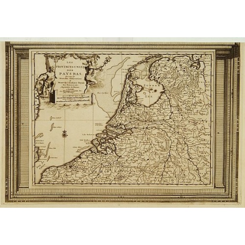
Les Provinces Unies des Pays Bas, suivant les nouvelles observations. . .
With decorative title cartouche upper left corner.This example is unusual in having the additional separately engraved decorative framework border around the map, the resultant visual effect being particularly striking. The frame border was prepared with a blank center so that the map could be over-printed on that area.These separately engraved border frames appear much more uncommon than the standard edition without border frames. From Le Nouveau Theatre du Monde, ou la Geographie Royale.
$250
Maker : AA, P. van der
Place : Amsterdam
Date : 1728
Postage & Shipping
-
Item Location
Terms and conditions - Item Location
- 75013, Ile-de-France, France
- Ships To
- United States, United Kingdom, Albania, Argentina, Armenia, Australia, Azerbaijan, Bahamas, Belgium, Bermuda, Cambodia, Canada, Chile, China, Croatia, Cyprus, Czech Republic, Denmark, Estonia, Finland, France, Germany, Gibraltar, Greece, Greenland, Guatemala, Hong Kong, Iceland, India, Indonesia, Israel, Italy, Japan, Latvia, Lithuania, Luxembourg, Malta, Mexico, Monaco, Netherlands, Norway, Singapore, Spain, Sweden, Switzerland, Turkey
- Pick-ups
- No pick-ups
This item is owned and offered by the seller Paulus_Swaen_Old_Maps - All items are available for immediate sale, offered subject to prior sale.
Invoices are created by the seller by using our shopping cart or be prepared by the seller the day following the order and are emailed to you.
Items offeres by different sellers are invoiced separately.
Shipping fees are extra. The buyer is responsible for all applicable taxes, including any VAT, customs clearance, import duties, or equivalent costs arriving at the customer's home border. Payment is due on receipt of the invoice. The item(s) are shipped as soon as possible after receipt of your payment.
Before buying please read the complete Terms Conditions of Sale.
- Payment Methods
- Visa, Mastercard, Bank Transfer, iDEAL, PayPal
- Returns Accepted
- No
Post Message
Feel free to ask the seller a question. Please note that the seller could be located in an area with a different time zone. Our seller will do their best to respond within 24 hours.Post your message below.
Sign in to ask the seller a question.