ID: 322
Open
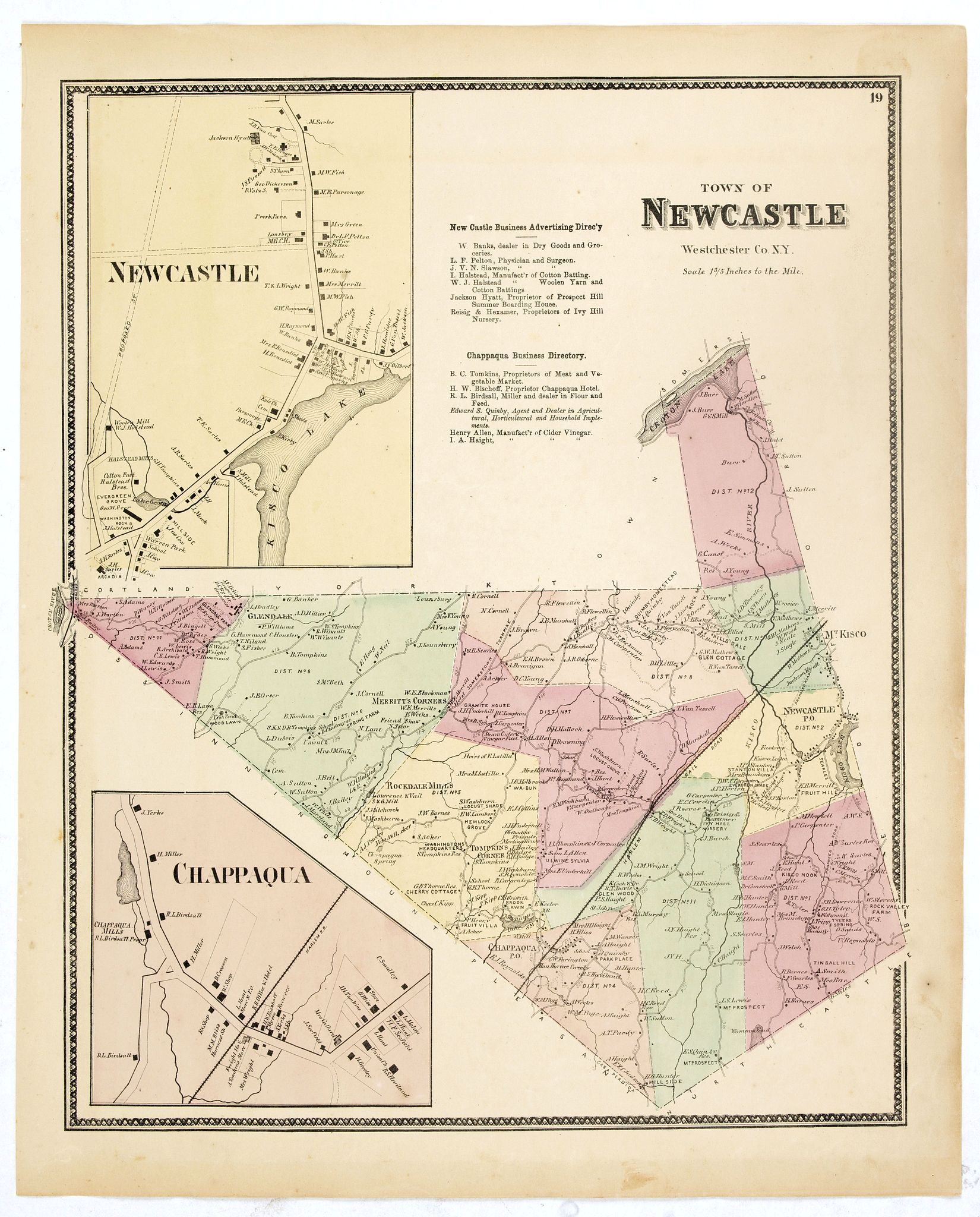
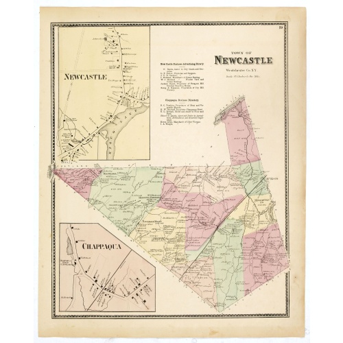
Town of New Castle. Westchester Co. NY.
BuyNow for $90
- Maker :
- DE BEERS, F.W.
- Place :
- New York, 1867
- Date :
- 1867
- Color :
- Oroginal colors
- Height mm.:
- 405
- Width mm.:
- 323
- Condition :
- Folding map on onion skin paper. Some very light spotting but generally in very good to mint condition.
- Bibliography :
- Barbara B. McCorkle 'The Strange Case of F.W. Beers and The Atlas of New York and Vicinity' in Meridian 5, pp.39-43. cf. Phillips 2290; cf. Rumsey 4631. Ristow, American Maps and Mapmakers, chapter 25.
- Seller's ref. :
- 37652
This item is offered by Paulus_Swaen_Old_Maps
See other Items from this seller- Postage
-
Europe
$34 to France
- Select Country
- Zip/Post Code
- Quantity
$90
Description
Fine lithographed map of the town of New Castle. The map provides the names of specific homeowners, as well as information about the occupations and physical locations of the various tradesmen in each village from Beer's famous county atlas "Atlas of New York and vicinity, a documentary record of nineteenth-century life and delightful specimens of American folk art."F. W. Beers, along with other members of his family, were among the leading county atlas publishers in the period immediately following the Civil War. Their atlases provide "a detailed cartographical, biographical, and pictorial record of a large segment of rural America in the Victorian age" (Ristow).
Beers first published his Atlas of New York & Vicinity in 1867. McCorkle and others have observed that various issues of the atlas were published in that year and the following with significant differences in the number and selection of maps included by the publisher. This was the result of clever marketing by Beers, intending to sell the atlases to customers in specific regions.
More about "Atlas of New York and Vicinity" by F. W. Beers. [+]
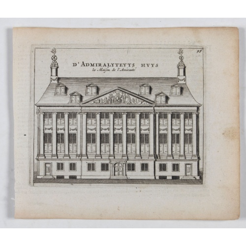
D' Admiralyteyts Huys - La maison de l'Amirauté.
Decorative print of the "D'Admiralyteits Huys", Het Prinsenhof, of the Dutch East India Company VOC. Located at the Oudezijds Voorburgwal 195-199, Amsterdam.
$150
Maker : ANONYMOUS
Place : Amsterdam
Date : ca. 1700
![Jules Verne. Le Tour du Monde en 80 jours. [Goose game board inspired by Jules Verne's novel Tour du Monde en 80 jours.]](/uploads/cache/44962-500x500.jpg)
Jules Verne. Le Tour du Monde en 80 jours. [Goose game board inspired by Jules Verne's novel Tour du Monde en 80 jours.]
This Goose game board is inspired by Jules Verne's novel whose boxes are illustrated with town views and figures and the center is occupied by a world map. Vignette illustrations numbered from 1 to 80, captioned in French and arranged counterclockwise.The game block illustrates views of arrival in New York (75), Chicago (68), San Francisco (57). The diverse illustrations also include Hong Kong, Singapore (44), Yankees (72), Japanese, Calcutta (25), Bombay (21), etc.The first two numbered blocks ...
$1.100
Maker : HETZEL, Jules.
Place : Paris
Date : 1876
![[Diego de Almagro is killed.]](/uploads/cache/40354-500x500.jpg)
[Diego de Almagro is killed.]
Almagro returned to Cuzco, disillusioned and embittered from his long and fruitless journey south into Chile, where he had been searching for further wealth. This led to a split in the control of Peru between the Pizarrists, who held the coastal regions, and the Almagrists who held the Cordillera. Further quarreling culminated in a battle just outside Cuzco in 1538, known as Las Salinas, which the Pizarrists eventually won. Almagro was subsequently garrotted and his captain, Orgóñez, beheaded....
$80
Maker : GOTTFRIED, J.L. / DE BRY.
Place : Frankfurt, M.Merian
Date : 1633
![[Captain Weert dines with the Chief].](/uploads/cache/39922-500x500.jpg)
[Captain Weert dines with the Chief].
Scarce print with a German text sheet. Captain Weert and the chief ate modestly on roast plantain, smoked fish and wine fermented from palm, bought by a local woman. However, when Weert ordered Spanish wine to be brought from his ship, the chief forgot his temperance and drank so much he had to be carried to rest. Weert had to stay the night but returned to his ship in the morning.On the way back he was confronted by an ugly, naked woman carrying ashes in a box. After circling him three times an...
$80
Maker : GOTTFRIED, J.L. / DE BRY.
Place : Frankfurt, M.Merian
Date : 1633
Postage & Shipping
-
Item Location
Terms and conditions - Item Location
- 75013, Alsace, France
- Ships To
- United States, United Kingdom, Albania, Argentina, Armenia, Australia, Azerbaijan, Bahamas, Belgium, Bermuda, Cambodia, Canada, Chile, China, Croatia, Cyprus, Czech Republic, Denmark, Estonia, Finland, France, Germany, Gibraltar, Greece, Greenland, Guatemala, Hong Kong, Iceland, India, Indonesia, Israel, Italy, Japan, Latvia, Lithuania, Luxembourg, Malta, Mexico, Monaco, Netherlands, Norway, Singapore, Spain, Sweden, Switzerland, Turkey
- Pick-ups
- No pick-ups
This item is owned and offered by the seller Paulus_Swaen_Old_Maps - All items are available for immediate sale, offered subject to prior sale.
Invoices are created by the seller by using our shopping cart or be prepared by the seller the day following the order and are emailed to you.
Items offeres by different sellers are invoiced separately.
Shipping fees are extra. The buyer is responsible for all applicable taxes, including any VAT, customs clearance, import duties, or equivalent costs arriving at the customer's home border. Payment is due on receipt of the invoice. The item(s) are shipped as soon as possible after receipt of your payment.
Before buying please read the complete Terms Conditions of Sale.
- Payment Methods
- Visa, Mastercard, Bank Transfer, American Express, iDEAL, PayPal, Google Pay
- Returns Accepted
- No
Post Message
Feel free to ask the seller a question. Please note that the seller could be located in an area with a different time zone. Our seller will do their best to respond within 24 hours.Post your message below.
Sign in to ask the seller a question.