
ID: 314
Open
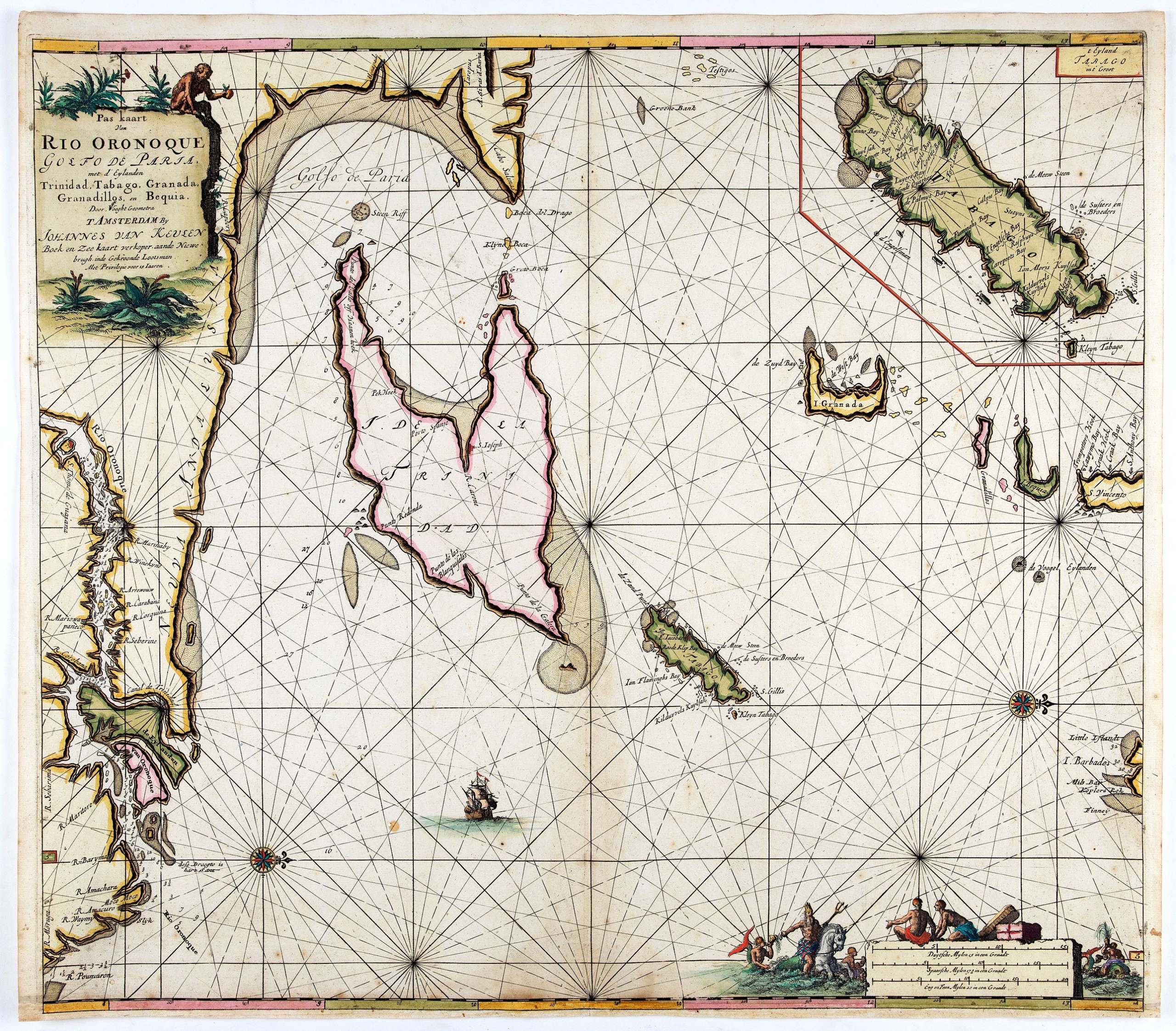
Pas kaart Van Rio Oronoque Golfo De Paria met d'Eylanden Trinidad, Tabago, Granada, Granadillos, en Bequia . . .
BuyNow for $900
- Maker :
- VAN KEULEN, J.
- Place :
- Amsterdam
- Date :
- 1684
- Color :
- Colored
- Height mm.:
- 589
- Width mm.:
- 1002
- Condition :
- Lower margin cut, on ply paper. Some light water staining in lower part center fold.
- Bibliography :
- -
- Seller's ref. :
- 47236
This item is offered by Paulus_Swaen_Old_Maps
See other Items from this seller- Postage
-
Europe
$34 to France
- Select Country
- Zip/Post Code
- Quantity
$900
Description
A highly detailed and rare sea chart of the mouth of the Orinoco River, Trinidad, Tabago, St.Vincent and neighboring islands. Oriented with north to the right by two compass roses.A large inset shows Tobago on a larger scale. Taken from De Nieuwe Groote Lichtende Zee-Fakkel, Part IV.
Decorative scale cartouche features Neptune with his entourage and natives with trade goods.
The chart is further adorned with a monkey atop the title cartouche and a sailing ship.
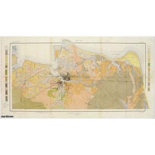
Soil map - Virginia Norfolk Sheet.
Soil map printed by Julius Bien & Co. in New York for the Department of Agriculture. The map gives great detail of the area centered on Norfolk, Potsmouth, Chesapeake, Virginia Beach in the year 1903. Soils are surveyed by J.E.Lapham in the same year. To the left and right, color keys to the different soil types.Upper left: U.S.Department of Agriculture, Bureau of soils, Milton Whitney, Chief.Julies Bien (later Bien & Co) was born and educated in Germany, and moved to America in 1849. He started...
$50
Maker : U.S. DEPT. OF ARGICULTURE
Place : New York 1903
Date : 1903
-500x500.jpg)
Virulus marinus. Cete (Whale and whaling scene)
Whale and whaling scene, set against a mountainous landscape in the manner of Pieter Brueghel the Elder. Plate number 1. The engraving is copied after Adrian Collaert plate in "Piscium Vivæ Icones" a series first published in Antwerp by Adriaen Collaert after 1598, later published between 1627 and 1677 by Galle family. Several copies were made of this series.Most of the ships in the background were copied from a series of ten prints known as the Sailing Vessels, executed by Frans Huys after des...
$300
Maker : COLLAERT, Adriaen (after)
Place : Antwerp
Date : after 1598

Descriptio Transisalaniae.
An original early 17th century copper engraved miniature antique map of the eastern Dutch region of Overijssel by Petrus Bertius. The title is displayed in a simple strapwork cartouche with the further title in bold letters above the map. Zwolle the capital city is engraved, along with Lochem, Zutphen, Apeldoorn, Deventer, Hengelo and Enschede. From the Bertius atlas Tabularum geographicarum contractarum. Bertius (1565-1629) was a Flemish cartographer, theologian, historian and geographer. Altho...
$100
Maker : LANGENES, B. / BERTIUS, P.
Place : Amsterdam
Date : 1606
![[Religious ritual on Hispaniola].](/uploads/cache/39921-500x500.jpg)
[Religious ritual on Hispaniola].
Scarce print with a German text sheet.On certain feast-days the Indian cacique, while beating a drum, led a procession of his people to the worship of their idol, which was a strange hybrid-like creature with several heads. The men were painted black, red and yellow and came first, dressed in parrot feathers and necklaces of seashells. The women, decorated with jewellery, followed with their naked daughters. When all were assembled, the cacique inserted a stake into his throat, which made him vo...
$80
Maker : GOTTFRIED, J.L. / DE BRY.
Place : Frankfurt, M.Merian
Date : 1633
Postage & Shipping
-
Item Location
Terms and conditions - Item Location
- 75013, Ile-de-France, France
- Ships To
- United States, United Kingdom, Albania, Argentina, Armenia, Australia, Azerbaijan, Bahamas, Belgium, Bermuda, Cambodia, Canada, Chile, China, Croatia, Cyprus, Czech Republic, Denmark, Estonia, Finland, France, Germany, Gibraltar, Greece, Greenland, Guatemala, Hong Kong, Iceland, India, Indonesia, Israel, Italy, Japan, Latvia, Lithuania, Luxembourg, Malta, Mexico, Monaco, Netherlands, Norway, Singapore, Spain, Sweden, Switzerland, Turkey
- Pick-ups
- No pick-ups
This item is owned and offered by the seller Paulus_Swaen_Old_Maps - All items are available for immediate sale, offered subject to prior sale.
Invoices are created by the seller by using our shopping cart or be prepared by the seller the day following the order and are emailed to you.
Items offeres by different sellers are invoiced separately.
Shipping fees are extra. The buyer is responsible for all applicable taxes, including any VAT, customs clearance, import duties, or equivalent costs arriving at the customer's home border. Payment is due on receipt of the invoice. The item(s) are shipped as soon as possible after receipt of your payment.
Before buying please read the complete Terms Conditions of Sale.
- Payment Methods
- Visa, Mastercard, Bank Transfer, American Express, iDEAL, PayPal, Google Pay
- Returns Accepted
- No
Post Message
Feel free to ask the seller a question. Please note that the seller could be located in an area with a different time zone. Our seller will do their best to respond within 24 hours.Post your message below.
Sign in to ask the seller a question.
