
ID: 494
Open
Listing ID: #494 has been added to your wishlist.
Listing ID: #388 has been added to your wishlist.
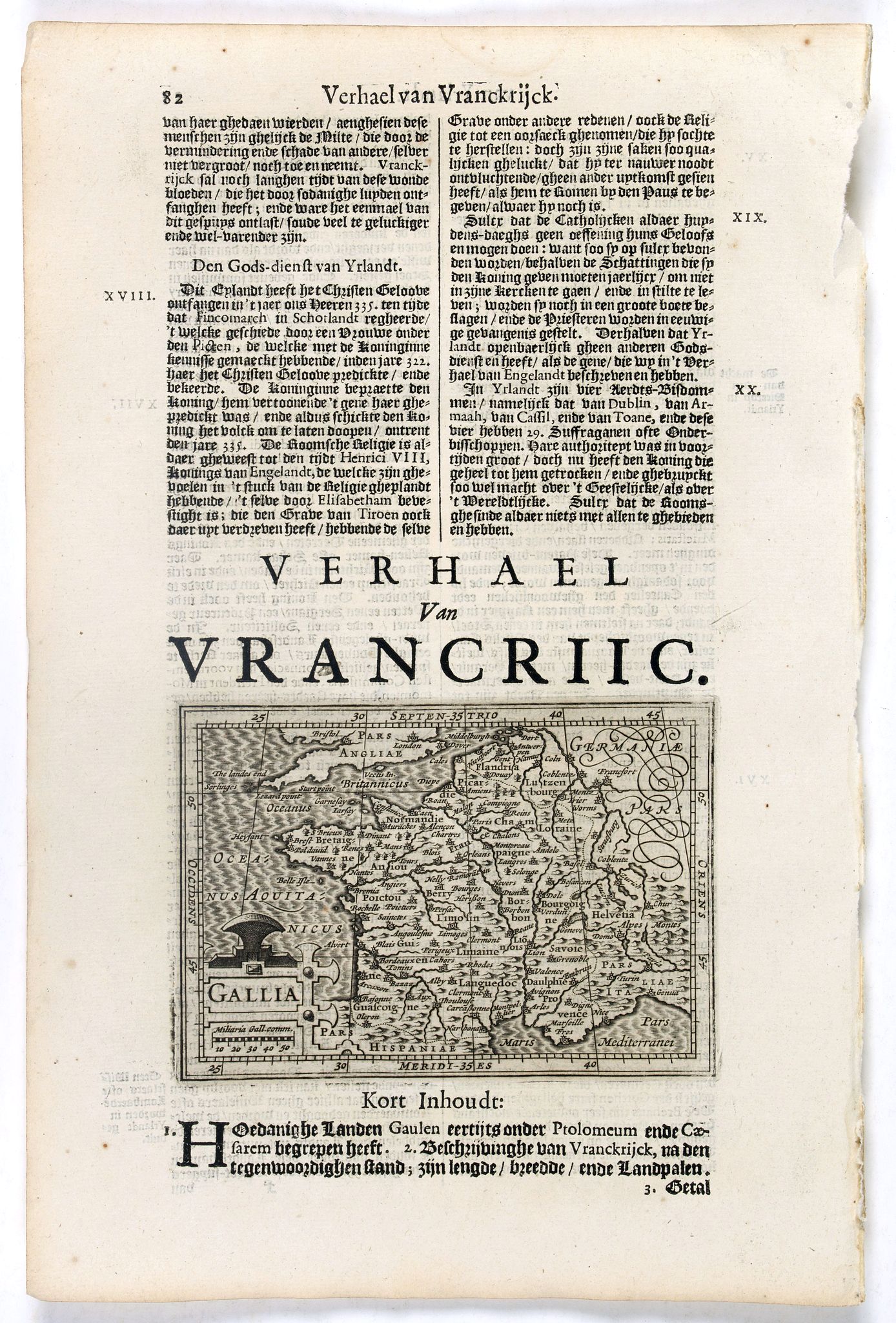
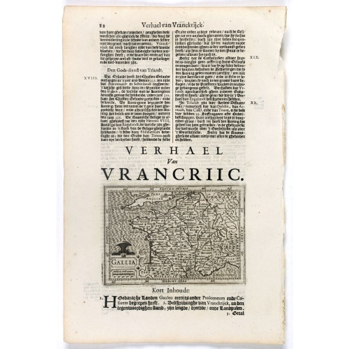
Gallia.
BuyNow for €70
- Maker :
- DE CLERCK, N.
- Place :
- Amsterdam, Cloppenburch
- Date :
- 1621
- Color :
- Uncoloured
- Height mm.:
- 94
- Width mm.:
- 133
- Condition :
- Mint condition. Size of paper : 31x 21cm.
- Bibliography :
- -
- Seller's ref. :
- 38100
This item is offered by Librairie_Loeb-Larocque
See other Items from this seller- Postage
-
France
€15 to France
- Select Country
- Zip/Post Code
- Quantity
€70
Description
Small map of France, surrounded by text in Dutch.
Nicolaes de Clerck (de Klerc) was active as engraver and publisher in Delft from 1599-1621.
Included in the rare book : Wereld Spiegel, waer in vertoontword de Beschryvinge der Rijken Staten, ende vorstendommen des gantsen Aerdbodems… which was a Dutch translation of "Les estats, empires et principautez de monde" by Pierre Davity.
The map is engraved by Jodocus Hondius before 1616 and first published in Petrus Bertius' revised pocket atlas Tabularum Geographicarum Contractarum Libri septem.. edition of 1616.
According to Peter van der Krogt in Atlantes Neerlandici, volume IIIA, page 442, the plates were used to illustrate some other books with maps, such as Paullus Merula's Cosmographia Generalis, printed in Leiden by Isaac Elsevier and in 1621 for the Wereld Spiegel.Cloppenburgh probably had borrowed the plates, since in the 1630s they were in the possession of Willem Jansz. Blaeu; who probably acquired them along with the plates for Jodocus Hondius Jr.'s Appendix. Blaeu; used the plates again for the Merula edition of 1635/36. Joan Blaeu; used these plates to produce an Atlas Minor without text.

Karte der Magellanischen-Strasse. . .
Very detailed map of Strait of Magellan, with in top inset map of Southern tip of South America with the Falklands. Prepared by Don Juan de La Cruz of Spain.Engraved by Jos. Gestner.
€600
Maker : SCHRAEMBL, F.A.
Place : Vienna
Date : 1787
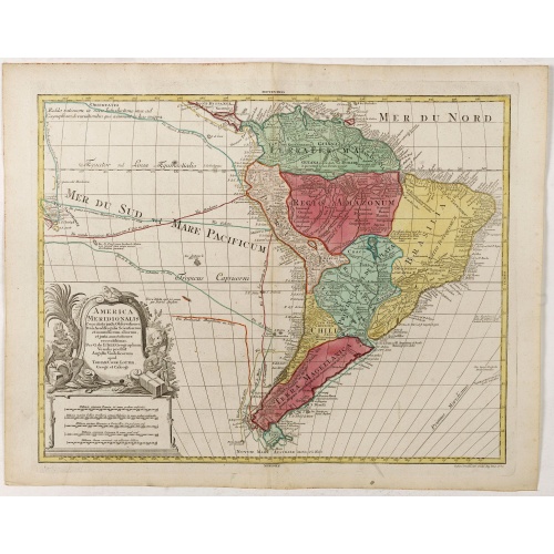
America Meridionalis.
The title cartouche lower left surrounded by native Indians and an Elephant.A rather accurate depiction and descriptions of South America. Brazil is slightly enlarged and bears mainly names of the costal zone. The inland was rather unknown at the time and regarded as both pagan and dangerous area like the Amazon.Argentina with Cape Horn and the Falkland Islands are merely deformed. The map was published by Matthäus Seutter's son in law Tobias Conrad Lotter, who continued the cartographical work...
€700
Maker : LOTTER, T.C.
Place : Augsburg
Date : ca. 1760
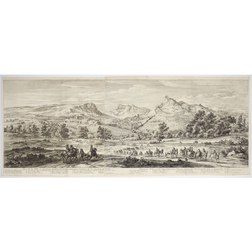
Veue de la ville, et fauxbourg de Salins…
Showing the town of Salins, a commune with salt works (Salines) in the Jura department in the region of Bourgogne-Franche-Comté in eastern France. With a key (1-15) in Latin and French to the most remarkable sights. Etching by A. F. Bauduins (Adrien François Baudouin) after Adam Frans van der Meulen (1632-1690) who was a Flemish Baroque painter specialising in battle scenes. He was active first in Brussels, where he was a pupil of Pieter Snayers, and from the 1660s onwards in Paris.His paint...
€700
Maker : MEULEN, Adam Frans van der.
Place : Paris
Date : 1680
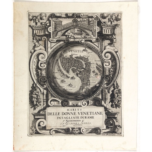
Habiti delle Donne Venetiane . . .
Title page of the book Habiti delle Donne Venetiane" (Dress of Venetian Women) which consists of twenty numbered plates of ornately dressed women. This very decorative title page shows in to Rialto Bridge and in the center a bird's-eye plan of Venice.Giacomo Franco (1556-1620) was born and grew in Venice, where he used to work. He was the son of painter Giovanni-Battista Franco (1510-1561), with whom he began his artistic training at the age of eleven. He worked as a painter, engraver, woodcutte...
€950
Maker : FRANCO, G.
Place : Venice
Date : ca. 1591
Postage & Shipping
-
Item Location
Terms and conditions - Item Location
- 75013, Ile-de-France, France
- Ships To
- United States, United Kingdom, Albania, Argentina, Armenia, Australia, Austria, Bahamas, Belgium, Bermuda, Bosnia and Herzegowina, Brazil, Bulgaria, Canada, Chile, China, Costa Rica, Denmark, Dominica, Egypt, El Salvador, Finland, France, Germany, Greece, Guatemala, Hong Kong, Hungary, Iceland, India, Italy, Japan, Korea (South), Kuwait, Liechtenstein, Lithuania, Luxembourg, Madagascar, Mexico, Monaco, Morocco, Netherlands, Netherlands Antilles, New Zealand, Norway, Paraguay, Peru, Philippines, Poland, Portugal, Qatar, Reunion, Romania, San Marino, Saudi Arabia, Seychelles, Singapore, Slovenia, South Africa, Spain, Sri Lanka, Suriname, Sweden, Switzerland, Taiwan, Thailand, Tunisia, Turkey, United Arab Emirates, Uruguay, Vietnam
- Pick-ups
- Buyer can pick-up
This item is owned and offered by the seller Librairie_Loeb-Larocque - All items are available for immediate sale, offered subject to prior sale.
Invoices are created by the seller by using our shopping cart or be prepared by the seller the day following the order and are emailed to you.
Items offeres by different sellers are invoiced separately.
Shipping fees are extra. The buyer is responsible for all applicable taxes, including any VAT, customs clearance, import duties, or equivalent costs arriving at the customer's home border. Payment is due on receipt of the invoice. The item(s) are shipped as soon as possible after receipt of your payment.
Before buying please read the complete Terms Conditions of Sale.
- Payment Methods
- Visa, Mastercard, Bank Transfer, American Express, iDEAL, PayPal, Google Pay
- Returns Accepted
- No
Post Message
Feel free to ask the seller a question. Please note that the seller could be located in an area with a different time zone. Our seller will do their best to respond within 24 hours.Post your message below.
Sign in to ask the seller a question.
![Venetia. [Venice ]](/uploads/cache/45176-500x500.jpg)