ID: 5
Open


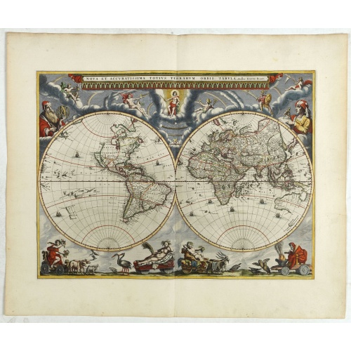
Nova et Accuratissima Totius Terrarum Orbis Tabula.
From his atlas Major.
BuyNow for $17.500
- Maker :
- BLAEU, J.
- Place :
- Amsterdam
- Date :
- 1662
- Color :
- In original colors
- Height mm.:
- 405
- Width mm.:
- 545
- Condition :
- Mint condition with very large margins. French text on verso.
- Bibliography :
- -
- Seller's ref. :
- 42850
This item is offered by Paulus_Swaen_Old_Maps
See other Items from this seller- Postage
-
Standard Shipping
$0 to France
- Select Country
- Zip/Post Code
- Quantity
$17.500
Description
Since its appearance as an Appendix in 1630, the atlas launched by
Willem Blaeu and continued by his son Joan had expanded greatly. But
despite many new regional maps the world map remained unchanged. For
some reason, Joan Blaeu's important wall map of 1648 was not immediately
adapted by his firm for atlas use.
The New
World map prepared by Joan Blaeu for his eleven-volume 'Atlas Maior' in
1662 is, unlike its predecessor, in two hemispheres. Outside the twin
hemispheres at the top are celestial figures seated amid clouds: below
are representations of the four seasons, with each allegorical figure
seated in an appropriate chariot quaintly drawn by pairs of beasts and
birds. As with all productions by the firm of Blaeu, the engraving and
layout and elegance of decoration are all of the highest standards.

Pas kaart Van Rio Oronoque Golfo De Paria met d'Eylanden Trinidad, Tabago, Granada, Granadillos, en Bequia . . .
A highly detailed and rare sea chart of the mouth of the Orinoco River, Trinidad, Tabago, St.Vincent and neighboring islands. Oriented with north to the right by two compass roses.A large inset shows Tobago on a larger scale. Taken from De Nieuwe Groote Lichtende Zee-Fakkel, Part IV.Decorative scale cartouche features Neptune with his entourage and natives with trade goods. The chart is further adorned with a monkey atop the title cartouche and a sailing ship.
$900
Maker : VAN KEULEN, J.
Place : Amsterdam
Date : 1684
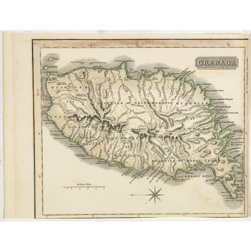
Grenada.
A delightfully detailed map the West Indian island Grenada by John Thomson. The map displays excellent detail concerning roads, rivers, towns, bays, harbours and other interesting topographical details.Thomson (1777-c1840) was a Scottish cartographer from Edinburgh, celebrated for his 1817 New General Atlas, published by himself in Edinburgh, John Cumming in Dublin, and Baldwin, Cradock, and Joy in London.
$50
Maker : THOMSON, J.
Place : Edenburgh
Date : 1821

Gelriae, Cliviae, Finitimorumque Locorum Verissima..
East to the top. Fine map of Geldria and Limburg, prepared by Christian s'Grooten. Very fine title cartouche lower right with painter's utensils around the cartouche.Dare to go in Black. All early maps were printed in black and white, and many were kept that way for a long time. A black and white map in an early and strong impression is a rarity nowadays, being so many examples recently colored up!
$250
Maker : ORTELIUS, A.
Place : Antwerp
Date : 1598
![[Black slaves escape punishment].](/uploads/cache/39920-500x500.jpg)
[Black slaves escape punishment].
Scarce print with a German text sheet. Many Black slaves, weary of ill treatment, managed to escape Spanish captivity and freely wandered the island, breaking into prisons and recruiting other slaves. Soon they outnumbered the Spanish and sought revenge by killing some of them. After a meeting at the governor’s palace in Santo Domingo, many Spanish soldiers were sent out to quell the rebellion by catching the Blacks by night and hanging them from trees. The Blacks learnt from this to keep a lo...
$80
Maker : GOTTFRIED, J.L. / DE BRY.
Place : Frankfurt, M.Merian, 1633
Date : 1633
Postage & Shipping
-
Item Location
Terms and conditions - Item Location
- 75013, Ile-de-France, France
- Ships To
- United States, United Kingdom, Albania, Argentina, Armenia, Australia, Azerbaijan, Bahamas, Belgium, Bermuda, Cambodia, Canada, Chile, China, Croatia, Cyprus, Czech Republic, Denmark, Estonia, Finland, France, Germany, Gibraltar, Greece, Greenland, Guatemala, Hong Kong, Iceland, India, Indonesia, Israel, Italy, Japan, Latvia, Lithuania, Luxembourg, Malta, Mexico, Monaco, Netherlands, Norway, Singapore, Spain, Sweden, Switzerland, Turkey
- Pick-ups
- Buyer can pick-up
This item is owned and offered by the seller Paulus_Swaen_Old_Maps - All items are available for immediate sale, offered subject to prior sale.
Invoices are created by the seller by using our shopping cart or be prepared by the seller the day following the order and are emailed to you.
Items offeres by different sellers are invoiced separately.
Shipping fees are extra. The buyer is responsible for all applicable taxes, including any VAT, customs clearance, import duties, or equivalent costs arriving at the customer's home border. Payment is due on receipt of the invoice. The item(s) are shipped as soon as possible after receipt of your payment.
Before buying please read the complete Terms Conditions of Sale.
- Payment Methods
- Visa, Mastercard, Bank Transfer, American Express, iDEAL, PayPal, Google Pay
- Returns Accepted
- No
Post Message
Feel free to ask the seller a question. Please note that the seller could be located in an area with a different time zone. Our seller will do their best to respond within 24 hours.Post your message below.
Sign in to ask the seller a question.