ID: 343
Open
Listing ID: #343 has been added to your wishlist.
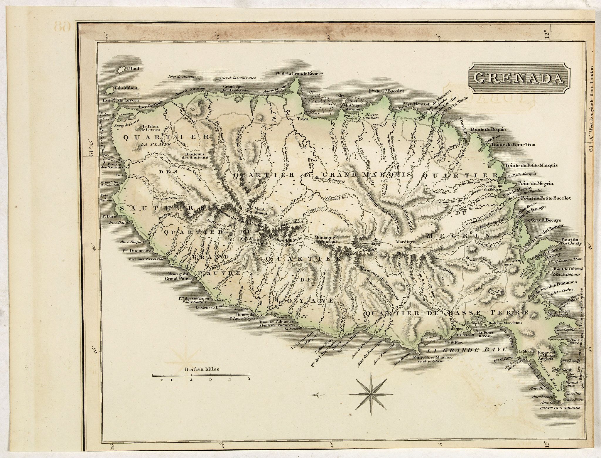
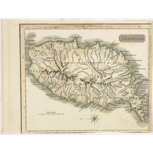
Grenada.
BuyNow for $50
- Maker :
- THOMSON, J.
- Place :
- Edenburgh
- Date :
- 1821
- Color :
- Colored
- Height mm.:
- 247
- Width mm.:
- 299
- Condition :
- Light offsetting, some discoloration. Cut from a larger sheet. Lower and right margin cut to neat line.
- Bibliography :
- -
- Seller's ref. :
- 43848
This item is offered by Paulus_Swaen_Old_Maps
See other Items from this seller- Postage
-
Europe
$34 to France
- Select Country
- Zip/Post Code
- Quantity
$50
Description
A delightfully detailed map the West Indian island Grenada by John Thomson.The map displays excellent detail concerning roads, rivers, towns, bays, harbours and other interesting topographical details.
Thomson (1777-c1840) was a Scottish cartographer from Edinburgh, celebrated for his 1817 New General Atlas, published by himself in Edinburgh, John Cumming in Dublin, and Baldwin, Cradock, and Joy in London.
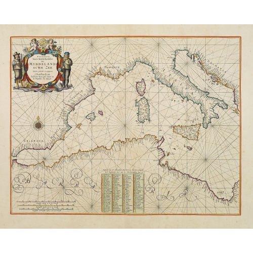
Pascaerte Van't Westelyckste der Middelandsche Zee. . .
An eye-catching chart of the western part of the Mediterranean Sea.Pieter Goos (ca. 1616-1675) was one of the most important cartographer, engraver, publisher and print seller of Amsterdam. His widow continued business at her husband's death. She re-issued the Nieuwe Groote Zee-Spiegel in 1676.In very decorative original colors. The compass rose and cartouche heightened with gold.The map is in a strictly contemporary coloring and of the highest level.
$3.750
Maker : GOOS, P.
Place : Amsterdam
Date : 1666

Pas kaart Van Rio Oronoque Golfo De Paria met d'Eylanden Trinidad, Tabago, Granada, Granadillos, en Bequia . . .
A highly detailed and rare sea chart of the mouth of the Orinoco River, Trinidad, Tabago, St.Vincent and neighboring islands. Oriented with north to the right by two compass roses.A large inset shows Tobago on a larger scale. Taken from De Nieuwe Groote Lichtende Zee-Fakkel, Part IV.Decorative scale cartouche features Neptune with his entourage and natives with trade goods. The chart is further adorned with a monkey atop the title cartouche and a sailing ship.
$900
Maker : VAN KEULEN, J.
Place : Amsterdam
Date : 1684

Kaerte en Afbeeldinge vande Geheele Jurisdictie van Stantdarbuyten Gelegen in de Generaliteit onder Marquisaet van Bergen op den Zoom
With a large title cartouche with signature of the maker Adriaan van der Ende, : Kaerte en Afbeeldinge vande Geheele Jurisdictie van Stantdarbuyten Gelegen in de Generaliteit onder Marquisaet van Bergen op den Zoom, gemaekt, en in den Jare van 1733, 1734, 1735 gemeten by my ondergetz… Willemstadt den 8 Julij 1737 Adr: van Enden.Adriaan van de Ende was a surveyor, appointed by the Council of Brabant in 1720, then living in Heyningen. Was later living and active in Willemstad.Other manuscript m...
$2.500
Maker : VAN DE ENDEN, A.
Place : Willemstadt
Date : 1737

A ship's hour glass.
Maritime hourglass with blown glass bulbs, orange sand, junction ring covered with cord, the circular ebony frame with six turned baluster columns. The invention of the hourglass is attributed to an 8th-century monk in Chartres, France, with the marine sandglass appearing as early as the 14th century. In earlier examples, the bulbs were connected with a material such as putty or hardened wax, bound in leather, linen or string. From about 1720, the two bulbs were welded together over a brass bead...
$2.000
Maker : ANONYMOUS
Place : Germany
Date : ca. 1750
Postage & Shipping
-
Item Location
Terms and conditions - Item Location
- Amsterdam, , Netherlands
- Ships To
- United States, United Kingdom, Albania, Argentina, Armenia, Australia, Azerbaijan, Bahamas, Belgium, Bermuda, Cambodia, Canada, Chile, China, Croatia, Cyprus, Czech Republic, Denmark, Estonia, Finland, France, Germany, Gibraltar, Greece, Greenland, Guatemala, Hong Kong, Iceland, India, Indonesia, Israel, Italy, Japan, Latvia, Lithuania, Luxembourg, Malta, Mexico, Monaco, Netherlands, Norway, Singapore, Spain, Sweden, Switzerland, Turkey
- Pick-ups
- No pick-ups
This item is owned and offered by the seller Paulus_Swaen_Old_Maps - All items are available for immediate sale, offered subject to prior sale.
Invoices are created by the seller by using our shopping cart or be prepared by the seller the day following the order and are emailed to you.
Items offeres by different sellers are invoiced separately.
Shipping fees are extra. The buyer is responsible for all applicable taxes, including any VAT, customs clearance, import duties, or equivalent costs arriving at the customer's home border. Payment is due on receipt of the invoice. The item(s) are shipped as soon as possible after receipt of your payment.
Before buying please read the complete Terms Conditions of Sale.
- Payment Methods
- Visa, Mastercard, Bank Transfer, American Express, iDEAL, PayPal, Google Pay
- Returns Accepted
- No
Post Message
Feel free to ask the seller a question. Please note that the seller could be located in an area with a different time zone. Our seller will do their best to respond within 24 hours.Post your message below.
Sign in to ask the seller a question.