ID: 150
Open
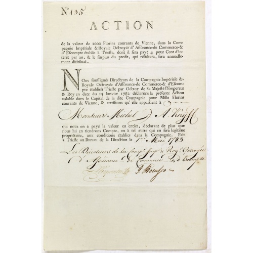
Share of 1000 Florins to Michel de Knyff. N° 135.
BuyNow for $1.500
- Maker :
- COMPAGNIE IMPERIALE & ROYALE
- Place :
- Trieste
- Date :
- 1782 - 1783
- Color :
- Uncoloured
- Height mm.:
- 335
- Width mm.:
- 215
- Condition :
- Size of paper sheet 335 x 215mm. Three horizontal fold. Very fine condition.
- Bibliography :
- Généalogie de Knyff, in: Annuaire de la noblesse de Belgique, Brussel, 1852.
- Seller's ref. :
- 42957
This item is offered by Paulus_Swaen_Old_Maps
See other Items from this seller- Postage
-
Standard Shipping
$0 to United States
- Select Country
- Zip/Post Code
- Quantity
$1.500
Description
Share of 1000 Florins, paid in four tranches at 250 Florins of Vienna, from "Compagnie Imperiale & Royale Octroyee d'Assurance de Commerce & d'escompte." dated in manuscript, Trieste, May 1, 1783. Share made out to Michel de Knyff of Antwerp.In their high-flying plans, the proud Habsburg monarchy very often relied on the money of the wealthy Antwerp bankers and wholesalers, who at that time belonged to the Austrian Netherlands. Among the financiers was the famous bank of Ertborn & Fils among many Antwerp bankers, noble and rich families.
This Share made out to Michel de Knyff (1720-1797), who was a member of a noble Belgium family. Michel de Knyff was the son of Jacques Knyff (1681-1756) who in 1719, was granted by the Emperor Charles VI, along the irregular channel of the Imperial Chancellery, the Knight's title of the Holy Roman Empire. In 1734 the noble favor was confirmed to Jacques Knyffe, this time through the regular channel of the chancellery in the Austrian Netherlands.
In 1756 Empress Maria Theresia gave the personal title knight to two sons of Jacques Knyff: one was Michel who was the owner of this share.

A new mape of Ye XVII Provinces of Low Germanie.
Showing all 17 Provinces of the Netherlands before the split between Spain and the Protestant Provinces under the House of Orange.The map was first published. At the same time, the war of independence was still being fought against Philip II. With columns of figures on either side and surmounted by eight city prospects. A famous and most decorative item.A fourth state published by Thomas Basset and Richard Chiswell. The date has been removed and Speed's name has been added to the title cartouche...
$2.300
Maker : SPEED, J.
Place : London, 1676
Date : 1626

Descriptio Transisalaniae.
An original early 17th century copper engraved miniature antique map of the eastern Dutch region of Overijssel by Petrus Bertius. The title is displayed in a simple strapwork cartouche with the further title in bold letters above the map. Zwolle the capital city is engraved, along with Lochem, Zutphen, Apeldoorn, Deventer, Hengelo and Enschede. From the Bertius atlas Tabularum geographicarum contractarum. Bertius (1565-1629) was a Flemish cartographer, theologian, historian and geographer. Altho...
$100
Maker : LANGENES, B. / BERTIUS, P.
Place : Amsterdam
Date : 1606
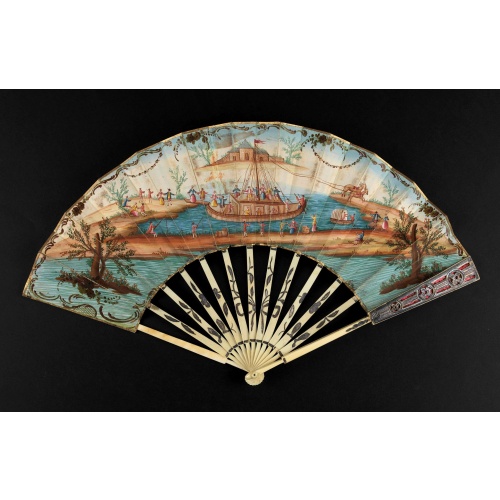
A folding fan showing a nautical festival, ca. 1770.
Folded fan, painted in gouache a ship pulled by two horses. On board, a large company, among others joins them while fishermen watch the scene.Reverse painted with an exotic flower. Monogram "SK" on the left.The ivory frame is engraved with flowers enhanced with silver foil.
$1.500
Maker : ANONYMOUS
Place : France
Date : ca. 1770
![[Captain Weert dines with the Chief].](/uploads/cache/39922-500x500.jpg)
[Captain Weert dines with the Chief].
Scarce print with a German text sheet. Captain Weert and the chief ate modestly on roast plantain, smoked fish and wine fermented from palm, bought by a local woman. However, when Weert ordered Spanish wine to be brought from his ship, the chief forgot his temperance and drank so much he had to be carried to rest. Weert had to stay the night but returned to his ship in the morning.On the way back he was confronted by an ugly, naked woman carrying ashes in a box. After circling him three times an...
$80
Maker : GOTTFRIED, J.L. / DE BRY.
Place : Frankfurt, M.Merian
Date : 1633
Postage & Shipping
-
Item Location
Terms and conditions - Item Location
- 75013, Alsace, France
- Ships To
- United States, United Kingdom, Albania, Argentina, Armenia, Australia, Azerbaijan, Bahamas, Belgium, Bermuda, Cambodia, Canada, Chile, China, Croatia, Cyprus, Czech Republic, Denmark, Estonia, Finland, France, Germany, Gibraltar, Greece, Greenland, Guatemala, Hong Kong, Iceland, India, Indonesia, Israel, Italy, Japan, Latvia, Lithuania, Luxembourg, Malta, Mexico, Monaco, Netherlands, Norway, Singapore, Spain, Sweden, Switzerland, Turkey
- Pick-ups
- No pick-ups
This item is owned and offered by the seller Paulus_Swaen_Old_Maps - All items are available for immediate sale, offered subject to prior sale.
Invoices are created by the seller by using our shopping cart or be prepared by the seller the day following the order and are emailed to you.
Items offeres by different sellers are invoiced separately.
Shipping fees are extra. The buyer is responsible for all applicable taxes, including any VAT, customs clearance, import duties, or equivalent costs arriving at the customer's home border. Payment is due on receipt of the invoice. The item(s) are shipped as soon as possible after receipt of your payment.
Before buying please read the complete Terms Conditions of Sale.
- Payment Methods
- Visa, Mastercard, Bank Transfer, American Express, iDEAL, PayPal, Google Pay
- Returns Accepted
- No
Post Message
Feel free to ask the seller a question. Please note that the seller could be located in an area with a different time zone. Our seller will do their best to respond within 24 hours.Post your message below.
Sign in to ask the seller a question.