
ID: 219
Open
Listing ID: #219 has been added to your wishlist.
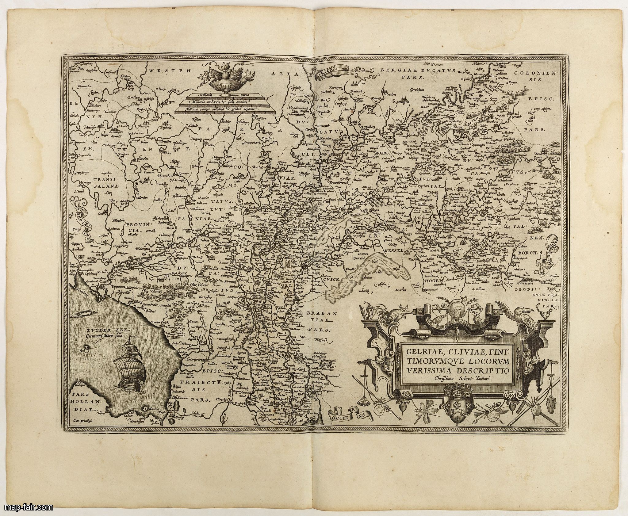
Gelriae, Cliviae, Finitimorumque Locorum Verissima..
BuyNow for $250
- Maker :
- ORTELIUS, A.
- Place :
- Antwerp
- Date :
- 1598
- Color :
- Uncoloured
- Height mm.:
- 370
- Width mm.:
- 500
- Condition :
- French text on the verso. Wide margins and very dark impression. Water stain in left and right margin. Paper very slightly age toned but generally in very fine condition.
- Bibliography :
- Van den Broecke, Ortelius Atlas maps, 62.
- Seller's ref. :
- 40954
This item is offered by Paulus_Swaen_Old_Maps
See other Items from this seller- Postage
-
Europe
$34 to France
- Select Country
- Zip/Post Code
- Quantity
$250
Description
East to the top. Fine map of Geldria and Limburg, prepared by Christian s'Grooten. Very fine title cartouche lower right with painter's utensils around the cartouche.Dare to go in Black. All early maps were printed in black and white, and many were kept that way for a long time. A black and white map in an early and strong impression is a rarity nowadays, being so many examples recently colored up!
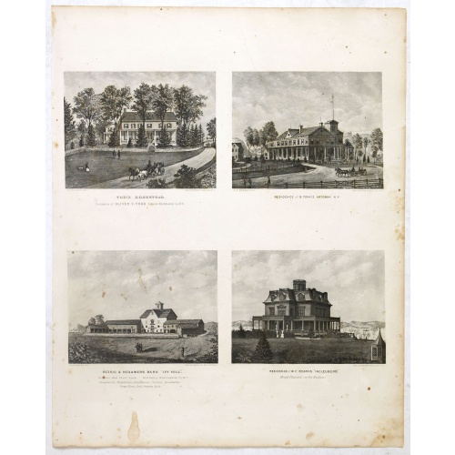
Todd Homestead / Résidence of B. Travis Katonah N.Y / Reisig & HexamersBarn Ivy Hill / Résidence of W.F Bearns
Four heliographic prints on one sheet : "Todd Homestead / Résidence of B. Travis Katonah N.Y / Reisig & HexamersBarn Ivy Hill / Résidence of W.F Bearns "Ingleuberg". After design by R.K.Sneden.From Beer's famous county atlas "Atlas of New York and vicinity", "a documentary record of nineteenth century life and delightful specimens of American folk art".F. W. Beers, along with other members of his family, were among the leading county atlas publishers in period immediately following the Civil W...
$90
Maker : DE BEERS, F.W.
Place : New York
Date : 1867

Pas-Caart van Hispangien vertoonde de Custen van Granade…
An eye-catching chart of Spain and Portugal, including a large part of Brittany and the southwestern coast of France, including Isle de Reé , Isle Saint Martin ...Pieter Goos (ca. 1616-1675) was one of the most important cartographers, engraver, publisher and print seller of Amsterdam. His widow continued business at her husband's death. She re-issued 'Nieuwe Groote Zee-Spiegel in 1676.The chart is in a strictly contemporary coloring and of the highest level.
$1.000
Maker : GOOS, P.
Place : Amsterdam
Date : 1669-1676

Rotterdam
A bird's-eye view of the town. With extensive shipping in the foreground. From "Topographia Germaniae Inferioris". Matthäus Merian, the leading German illustrator of the 17th century, was born in Basel in 1593. He learned the art of copperplate engraving in Zurich and subsequently worked and studied in Strasbourg, Nancy, Paris, and the Low Countries. In 1618 he went to Frankfurt, wherein 1618 he marries the eldest daughter of J.T. de Bry, publisher and engraver. After de Bry died in 1623, he ...
$1.750
Maker : MERIAN, C.
Place : Frankfurt
Date : 1659
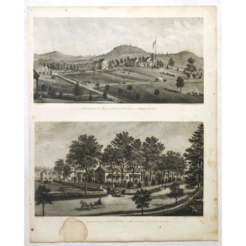
Résidence of WM H.Drew Southeast Putnam Co.N.Y / Lake Farm Résidence of John V.Storm East Fiskill Dutches Co.N.Y.
Two heliographic prints on one sheet : " Résidence of WM H.Drew Southeast Putnam Co.N.Y / Lake Farm Résidence of John V.Storm East Fiskill Dutches Co.N.Y." after design by R.K.Sneden.From Beer's famous county atlas "Atlas of New York and vicinity", "a documentary record of nineteenth century life and delightful specimens of American folk art". F. W. Beers, along with other members of his family, were among the leading county atlas publishers in period immediately following the Civil War. Their...
$90
Maker : DE BEERS, F.W.
Place : New York,1867
Date : 1867
Postage & Shipping
-
Item Location
Terms and conditions - Item Location
- 75013, Ile-de-France, France
- Ships To
- United States, United Kingdom, Albania, Argentina, Armenia, Australia, Azerbaijan, Bahamas, Belgium, Bermuda, Cambodia, Canada, Chile, China, Croatia, Cyprus, Czech Republic, Denmark, Estonia, Finland, France, Germany, Gibraltar, Greece, Greenland, Guatemala, Hong Kong, Iceland, India, Indonesia, Israel, Italy, Japan, Latvia, Lithuania, Luxembourg, Malta, Mexico, Monaco, Netherlands, Norway, Singapore, Spain, Sweden, Switzerland, Turkey
- Pick-ups
- No pick-ups
This item is owned and offered by the seller Paulus_Swaen_Old_Maps - All items are available for immediate sale, offered subject to prior sale.
Invoices are created by the seller by using our shopping cart or be prepared by the seller the day following the order and are emailed to you.
Items offeres by different sellers are invoiced separately.
Shipping fees are extra. The buyer is responsible for all applicable taxes, including any VAT, customs clearance, import duties, or equivalent costs arriving at the customer's home border. Payment is due on receipt of the invoice. The item(s) are shipped as soon as possible after receipt of your payment.
Before buying please read the complete Terms Conditions of Sale.
- Payment Methods
- Payment Simulator, Visa, Mastercard, Bank Transfer, PayPal
- Returns Accepted
- No
Post Message
Feel free to ask the seller a question. Please note that the seller could be located in an area with a different time zone. Our seller will do their best to respond within 24 hours.Post your message below.
Sign in to ask the seller a question.
