
ID: 72
Closed
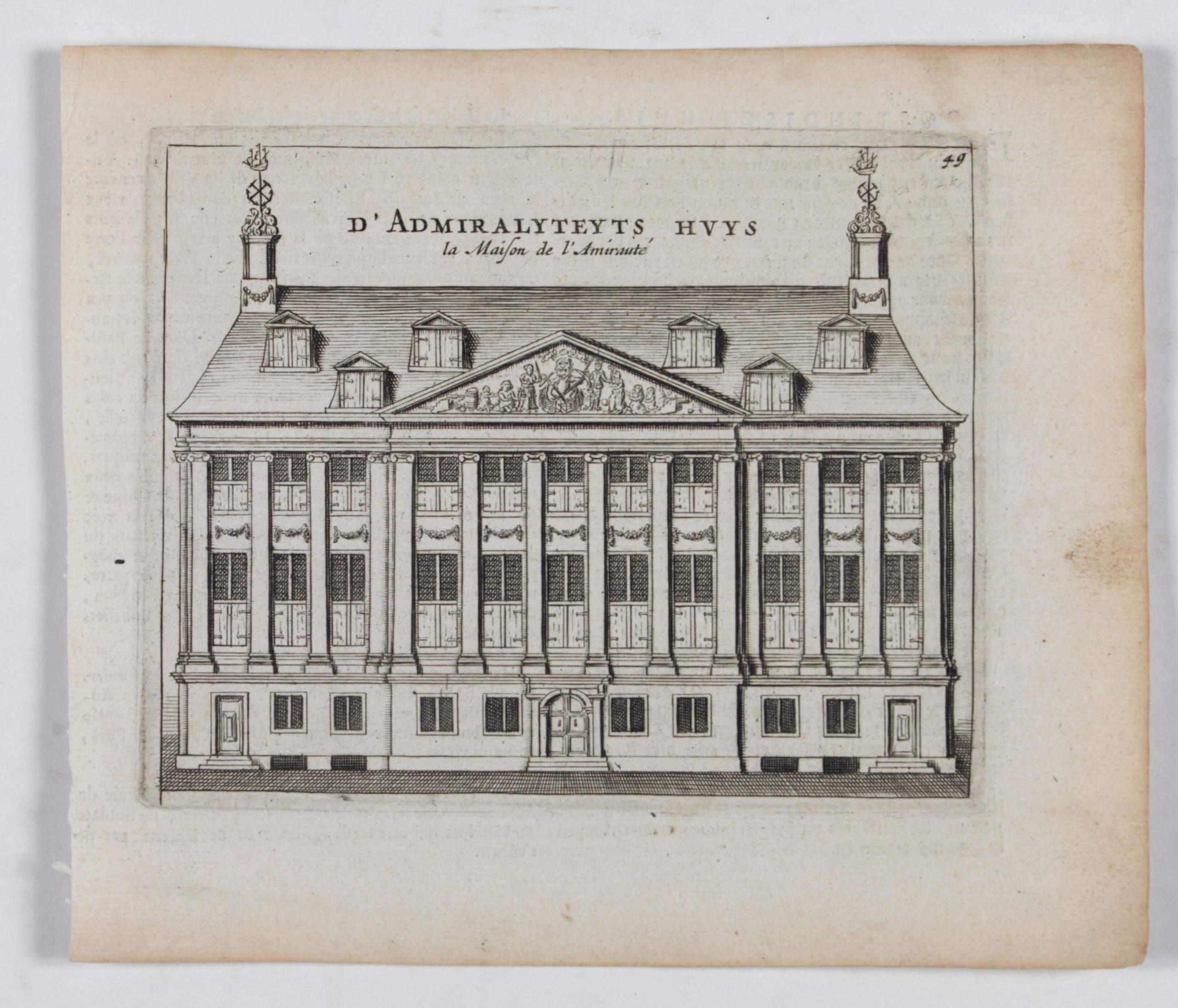
D' Admiralyteyts Huys - La maison de l'Amirauté.
BuyNow for $150
- Maker :
- ANONYMOUS
- Place :
- Amsterdam
- Date :
- ca. 1700
- Color :
- Uncolored
- Height mm.:
- 108
- Width mm.:
- 135
- Condition :
- Some age toning of paper. Good impression. Faint shinethrough of the Dutch/French text on verso. Else good condition.
- Bibliography :
- -
- Seller's ref. :
- 22709
This item is offered by Paulus_Swaen_Old_Maps
See other Items from this seller- Postage
-
Europe
$34 to Netherlands
- Select Country
- Zip/Post Code
- Quantity
$150
Description
Decorative print of the "D'Admiralyteits Huys", Het Prinsenhof, of the Dutch East India Company VOC. Located at the Oudezijds Voorburgwal 195-199, Amsterdam.![[Printed on silk] Nieuw Wassende Graaden Paskaart Vertoonende alle de bekende Zeekusten en Landen op den geheelen Aard Boodem of Werelt door Gerard van Keulen. . .](/uploads/cache/31640-500x500.jpg)
[Printed on silk] Nieuw Wassende Graaden Paskaart Vertoonende alle de bekende Zeekusten en Landen op den geheelen Aard Boodem of Werelt door Gerard van Keulen. . .
A very scarce and beautiful chart on Mercator's projection printed on silk. The map is printed on silk. With the name of Gerard van Keulen and the privilege. The map shows great interior detail, including a well-formed depiction of the Great Lakes and Mississippi River. Fort de Creveceur is shown near the Illinois River. The east coast of Siberia has been drawn after Nicolas Witsen's 1687 map of Tartary. A Great Companies Land has been added off the northwest coast of America. California is an i...
$20.000
Maker : VAN KEULEN, G.
Place : Amsterdam
Date : 1728

Vertoog van het regt, Dat de Vereenigde Nederlandsche Oost-Indische maatschappye Heeft op de Vaart en Koophandel naar Oost-Indiën, Tegen de inwooners van de Spaanse, nu de Oostenrykse Nederlanden.
Dutch translation of the Latin edition, published in 1723. Westerveen was the secretary of the Dutch East India Company and writes on the right of the VOC to trade as well as on VOC maritime trade with the East Indies. Westerveen also addresses these matters with regard to the Dutch West India Company and deals with Dutch trade in the light of the interests of both Spain and Portugal in the Americas and in Asia.Also contains an interesting Extract uyt de Resolutien door den Gouverneur Generaal e...
$1.200
Maker : WESTERVEEN, A.
Place : Amsterdam
Date : 1724

Freedom of the Air.
A world map packed with information about aviation and the aluminum industry.The use of aircraft in warfare, especially in the roles of close ground support and strategic bombing, was completely revolutionized during WWII. Apart from tactics, the technology also evolved to facilitate heavier bombers, faster fighters, more capable transports and greater range all-around. One critical component of this development was using light, flexible and sturdy aluminum frames and skins for the planes, rathe...
$230
Maker : ALCOA ALUMINUM COMPANY.
Place : United-States
Date : 1943

Pas-Kaat vaneen gedeelte van de Aethiopische Zee behelsende de Kusten Zanguebar, Ajan en Abex, en een gedeelte van de Arabische Kust. . .
A finely engraved and detailed chart of the most eastern tip of Africa, including Somalia, Djibouti, Yemen, Mauritius, and many other islands in the Indian Ocean.Very rare: only included in 6th volume (so-called secret atlas) of Van Keulen's. Latitude scale, compass rose and system of rhumb lines, soundings, anchorage's, etc. Many Dutch names and a wealth of cities and information appear in the chart. The trading posts of the different nations are marked with flags. Number 47. in lower left corn...
$4.500
Maker : VAN KEULEN, J.
Place : Amsterdam
Date : 1753
Postage & Shipping
-
Item Location
Terms and conditions - Item Location
- Amsterdam, , Netherlands
- Ships To
- United States, United Kingdom, Albania, Argentina, Armenia, Australia, Azerbaijan, Bahamas, Belgium, Bermuda, Cambodia, Canada, Chile, China, Croatia, Cyprus, Czech Republic, Denmark, Estonia, Finland, France, Germany, Gibraltar, Greece, Greenland, Guatemala, Hong Kong, Iceland, India, Indonesia, Israel, Italy, Japan, Latvia, Lithuania, Luxembourg, Malta, Mexico, Monaco, Netherlands, Norway, Singapore, Spain, Sweden, Switzerland, Turkey
- Pick-ups
- No pick-ups
This item is owned and offered by the seller Paulus_Swaen_Old_Maps - All items are available for immediate sale, offered subject to prior sale.
Invoices are created by the seller by using our shopping cart or be prepared by the seller the day following the order and are emailed to you.
Items offeres by different sellers are invoiced separately.
Shipping fees are extra. The buyer is responsible for all applicable taxes, including any VAT, customs clearance, import duties, or equivalent costs arriving at the customer's home border. Payment is due on receipt of the invoice. The item(s) are shipped as soon as possible after receipt of your payment.
Before buying please read the complete Terms Conditions of Sale.
- Payment Methods
- Visa, Mastercard, Bank Transfer, American Express, iDEAL, PayPal, Google Pay
- Returns Accepted
- No
Post Message
Feel free to ask the seller a question. Please note that the seller could be located in an area with a different time zone. Our seller will do their best to respond within 24 hours.Post your message below.
Sign in to ask the seller a question.
