ID: 93
Open
Listing ID: #93 has been added to your wishlist.

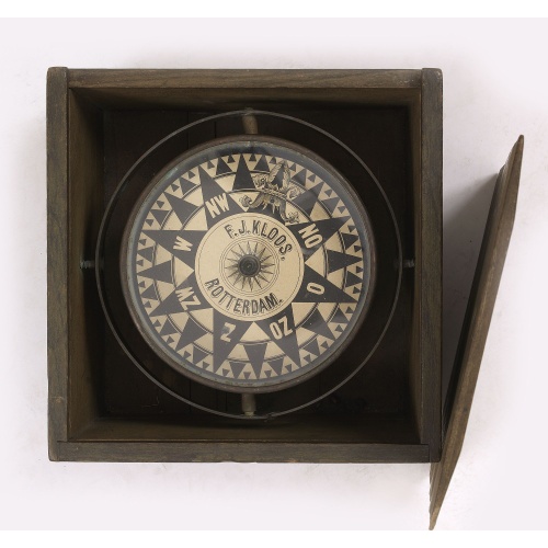
Compass.
BuyNow for $2.250
- Maker :
- KLOOS, F.J.
- Place :
- Rotterdam
- Date :
- 1850-1875
- Color :
- Uncoloured
- Height mm.:
- 240
- Width mm.:
- 240
- Condition :
- Height of the box: 13.5 cm (5.5 inches)
- Bibliography :
- -
- Seller's ref. :
- 24427
This item is offered by Paulus_Swaen_Old_Maps
See other Items from this seller- Postage
-
Standard Shipping
$0 to Netherlands
- Select Country
- Zip/Post Code
- Quantity
$2.250
Description
A very nicely crafted sloop compass in original box. The compass is gimbaled and is executed in beautiful red copper. Made and signed by F.J. Kloos & Son of Rotterdam in the 1850-1875 period. The compass works fine. Height of the box: 13.5 cm (5.5 inches)
Inventio Maris Magallanici.
Allegorical scene allegorical image celebrating the circumnavigation of the earth by Ferdinand Magellan. The image shows Magellan on board of his ship, surrounded by mythological figures including Apollo with sun and lyre, Zeus on his throne of clouds, Adam and Eve. A bird carrying an elephant and a depiction of the Tierra del Fuego.The image also includes cannon, banner with the double-headed Hapsburg eagle, anchor, broken mast, navigational instruments such as armillary sphere and dividers, se...
$750
Maker : DE BRY, Th.
Place : Frankfurt
Date : 1594

Regno de' Paesi-Bassi compresa la Olanda . . . / La Svizzera . . .
Two rare and detailed maps of The Netherland (210 x 230mm. ) and Switzerland (140 x 230mm.) According to the title cartouche, prepared by J.A.Buchon and A de La Sage for l'Atlante Storico, Letterario, Biografico, Archeologico. . . with attributions by Giambatista Albrizzi.Lower left a color-key, giving good detail and information. We were not able to find references to the publisher, engraver or author of this map. Uncommon and in very good condition.
$60
Maker : TASSO, G.
Place : Venice, 1840
Date : 1840
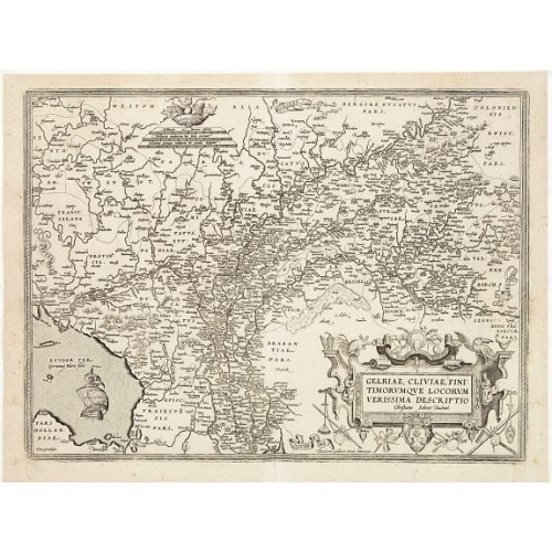
Gelriae, Cliviae, Finitimorumque Locorum Verissima Descriptio.
From the very rare Galle edition of the Ortelius Atlas, published after 1612. Fine map of Geldria and Limburg, prepared by Christian s'Grooten. Very fine title cartouche lower right with artist brushes and palettes as well as an owl gazing in a round mirror.East to the top.
$1.250
Maker : ORTELIUS, A. / GALLE, TH.
Place : Antwerp
Date : after 1612
![[Ternate].](/uploads/cache/37954-500x500.jpg)
[Ternate].
Text engraving showing a bay on the Island of Ternate, an island in the Maluku Islands (Moluccas) of eastern Indonesia. Above the map a lettered key (A-E). Text engraving from "Premier livre de l'histoire de la navigation aux Indes Orientales, par les hollandois, et des choses a eux advenues . . . ", being the classic account of the first Dutch voyage to the East Indies under the command of Cornelis de Houtman. the expedition left in 1595, after Holland had achieved independence from Spain and c...
$150
Maker : LODEWYCKSZ, Willem
Place : Amsterdam, Cornille Nicolas
Date : 1609
Postage & Shipping
-
Item Location
Terms and conditions - Item Location
- Paris, Alsace, France
- Ships To
- United States, United Kingdom, Albania, Argentina, Armenia, Australia, Azerbaijan, Bahamas, Belgium, Bermuda, Cambodia, Canada, Chile, China, Croatia, Cyprus, Czech Republic, Denmark, Estonia, Finland, France, Germany, Gibraltar, Greece, Greenland, Guatemala, Hong Kong, Iceland, India, Indonesia, Israel, Italy, Japan, Latvia, Lithuania, Luxembourg, Malta, Mexico, Monaco, Netherlands, Norway, Singapore, Spain, Sweden, Switzerland, Turkey
- Pick-ups
- No pick-ups
This item is owned and offered by the seller Paulus_Swaen_Old_Maps - All items are available for immediate sale, offered subject to prior sale.
Invoices are created by the seller by using our shopping cart or be prepared by the seller the day following the order and are emailed to you.
Items offeres by different sellers are invoiced separately.
Shipping fees are extra. The buyer is responsible for all applicable taxes, including any VAT, customs clearance, import duties, or equivalent costs arriving at the customer's home border. Payment is due on receipt of the invoice. The item(s) are shipped as soon as possible after receipt of your payment.
Before buying please read the complete Terms Conditions of Sale.
- Payment Methods
- Visa, Mastercard, Bank Transfer, American Express, iDEAL, PayPal, Google Pay
- Returns Accepted
- No
Post Message
Feel free to ask the seller a question. Please note that the seller could be located in an area with a different time zone. Our seller will do their best to respond within 24 hours.Post your message below.
Sign in to ask the seller a question.