ID: 377
Open
Listing ID: #377 has been added to your wishlist.
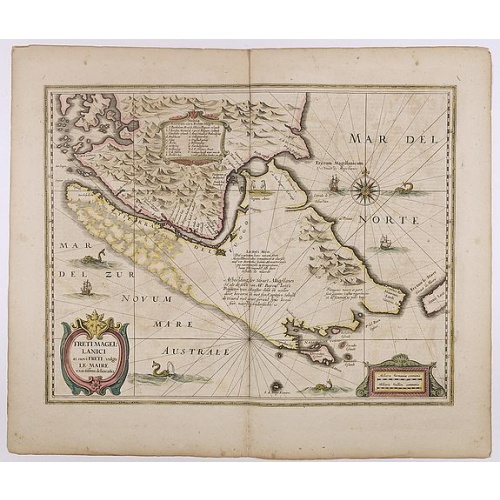
Freti Magellanici ac novi Freti vulgo Le Maire. . .
BuyNow for €800
- Maker :
- HONDIUS, H.
- Place :
- Amsterdam
- Date :
- ca. 1633
- Color :
- In original outline colors
- Height mm.:
- 383
- Width mm.:
- 490
- Condition :
- Paper slightly age toned. Good impression.
- Bibliography :
- -
- Seller's ref. :
- 40463
This item is offered by Librairie_Loeb-Larocque
See other Items from this seller- Postage
-
France
€15 to France
- Select Country
- Zip/Post Code
- Quantity
€800
Description
A fine map of Tierra del Fuego. With an explanatory text of the passage by Barent Jansz. Potgieter who accompanied captain Sebald de Weert to the Straits in 1599/1600, being the first Dutch vessels to sail through the Strait of Magellan, in Latin and Dutch.After various English voyages, the Dutch appeared in the Strait of Magellan in 1599. One of the Dutch pioneering voyages to the Southwest was the one by Jacques Mahu and Simon de Cordes, who were sent out by Rotterdam merchants.
The five ships of this fleet were the first Dutch vessels to sail through the Strait of Magellan. One of them, the De Liefde, completed the crossing of the Pacific, reached Japan and laid the foundations for Dutch trade there.
French text on verso.
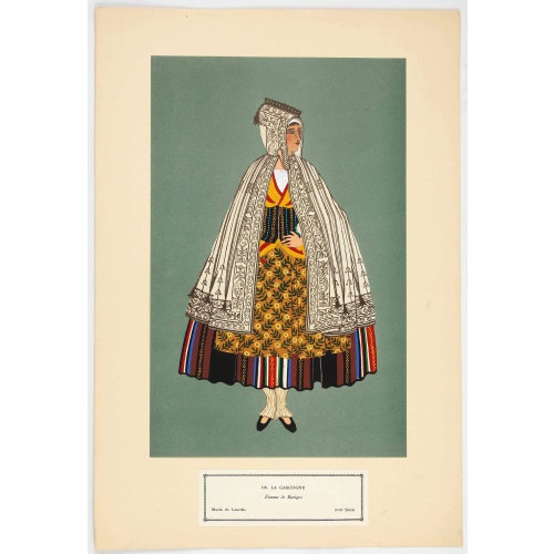
Femme de Barèges (106, La Gascogne).
Plate published in "Les costumes régionaux de France" with illustrations by Gratiane de Gardilanne (painter and designer) and Elisabeth Whitney Moffat.Costume plate printed in collotype, pochoir and retouched by hand. Dimension of 24.5 x 38cm. The originals were donated by an American patron to the Metropolitan Museum of Art in New York and constitute a set of 200 plates. Good condition.
€75
Maker : GARDILANNE (G.de) et MOFFAT (E.W.)
Place : Paris, Editions du Pégase, 1929
Date : 1929
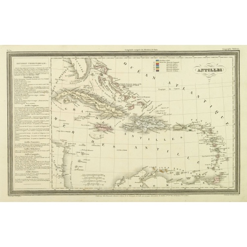
Antilles.
Finely engraved map of the Caribbean, with a color key to Spanish, English, French, Danish, Dutch and Swedish possessions, prepared by A.H.Dufour and engraved by Giraldon-Bovinet. Published by Jules Renouard in his uncommon atlas "Le globe Atlas classique Universel de géographie ancienne et moderne, pour servir a l'étude de la géographie et de l'histoire dressé par M. A.H.Dufour, Et revu par M.Jomard".To the left- "Tableau statistique", giving details on geographical, statistical and economi...
€75
Maker : DUFOUR, A.H.
Place : Paris, Jules Renouard
Date : ca. 1840
-500x500.jpg)
Dépt. De La Haute Loire. N°42.
Map of the Upper Loire region in France.Lovely map from one of the last decorative atlases of the nineteenth century.The rather simple map is framed by medallion portraits and coats of arms, and is set against a background of scenes of the countryside, products and activities indigenous to the region filling the foreground.Victor Levasseur's "Atlas National Illustre" and "Atlas Universel Illustre" are among the last great decorative atlases published. This map comes from the Atlas National Illus...
€50
Maker : LEVASSEUR, V.
Place : Paris
Date : A. Combette, 1852
![Venetia. [Venice ]](/uploads/cache/45176-500x500.jpg)
Venetia. [Venice ]
Very rare view of Venice published in the first edition of "Viaggio da Venetia, a Costantinopoli. Per Mare, e per Terra, & infieme quello di Terra Santa. Da Gioseppe Rosaccio con brevita descritto".Several of the maps and plans resemble those in G. F. Camocio's "Isole famose", in particular the maps of the individual Greek islands, among which are Corfu, Crete, Cyprus, together with a map of Palestine and a view of Jerusalem.It is possible that many of the plates may originate from 1590-1597, wh...
€420
Maker : ROSACCIO, Giuseppe
Place : Venice, Giacomo Franco, 1598
Date : 1598
Postage & Shipping
-
Item Location
Terms and conditions - Item Location
- 75013, Ile-de-France, France
- Ships To
- United States, United Kingdom, Albania, Argentina, Armenia, Australia, Austria, Bahamas, Belgium, Bermuda, Bosnia and Herzegowina, Brazil, Bulgaria, Canada, Chile, China, Costa Rica, Denmark, Dominica, Egypt, El Salvador, Finland, France, Germany, Greece, Guatemala, Hong Kong, Hungary, Iceland, India, Italy, Japan, Korea (South), Kuwait, Liechtenstein, Lithuania, Luxembourg, Madagascar, Mexico, Monaco, Morocco, Netherlands, Netherlands Antilles, New Zealand, Norway, Paraguay, Peru, Philippines, Poland, Portugal, Qatar, Reunion, Romania, San Marino, Saudi Arabia, Seychelles, Singapore, Slovenia, South Africa, Spain, Sri Lanka, Suriname, Sweden, Switzerland, Taiwan, Thailand, Tunisia, Turkey, United Arab Emirates, Uruguay, Vietnam
- Pick-ups
- No pick-ups
This item is owned and offered by the seller Librairie_Loeb-Larocque - All items are available for immediate sale, offered subject to prior sale.
Invoices are created by the seller by using our shopping cart or be prepared by the seller the day following the order and are emailed to you.
Items offeres by different sellers are invoiced separately.
Shipping fees are extra. The buyer is responsible for all applicable taxes, including any VAT, customs clearance, import duties, or equivalent costs arriving at the customer's home border. Payment is due on receipt of the invoice. The item(s) are shipped as soon as possible after receipt of your payment.
Before buying please read the complete Terms Conditions of Sale.
- Payment Methods
- Visa, Mastercard, Bank Transfer, American Express, iDEAL, PayPal, Google Pay
- Returns Accepted
- No
Post Message
Feel free to ask the seller a question. Please note that the seller could be located in an area with a different time zone. Our seller will do their best to respond within 24 hours.Post your message below.
Sign in to ask the seller a question.