

 Paryro beheert een collectie 16de-19de eeuwse zeekaarten en maritime tekeningen en prenten. Roland
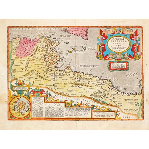
AFRICAE PROPRIAE TABULA In qua, Punica regna vides; Tyrios, et Agenoris / urbem.
AFRICAE PROPRIAE TABULA In qua, Punica regna vides; Tyrios, et Agenoris / urbem. Antique map of North Africa with Carthage. A very decorative map of North Africa with an inset with the town of Carthage. From the rare Spanish edition of Abraham Ortelius’ ‘Theatrum Orbis Terrarum’, published by Vrientius. Abraham Ortelius(1527-98), Dutch cartographer and publisher of the first modern atlas, ' Theatrum Orbis Terrarum' in 1570. Editions till 1612. Also an atlas of ancient cartography, the '...
€350
Maker : ORTELIUS, A.
Place : Antwerp
Date : 1590

(Sea-chart of Catalunia, Languedoc, Provence, Cote d'Azur, Riviera, Corsica with Marseille, Cannes, Nice, Monaco.)
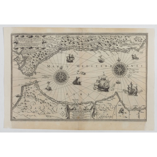
This very rare chart is important as the first printed sea chart of France's Mediterranean coast, also depicting Catalunya's northern coast, the Italian Cote d'Azur till San Remo and Corsica's west coast.Willem Barentsz (1560-1597) was a famous pilot, discoverer and cartographer. Author of 'Nieuwe Beschrhryvinghe ende caertboeck van de Midlantsche Zee', the first printed pilot-guide of the Mediterranean. It is considered the supplement of Waghenaer's 'Spieghel der Zeevaerdt' for the Mediterranea...
€4.000
Maker : BARENTSZ, Willem.
Place : Amsterdam
Date : 1607
Hydrograhica descriptio
This very rare chart is important as the first printed sea chart of the Mediterranean coast of Spain, Gibraltar, also depicting the northern coast of Marocco.Willem Barentsz (1560-1597) was a famous pilot, discoverer and cartographer. Author of 'Nieuwe Beschrhryvinghe ende caertboeck van de Midlantsche Zee', the first printed pilot-guide of the Mediterranean. It is considered the supplement of Waghenaer's 'Spieghel der Zeevaerdt' for the Mediterranean waters.
€4.000
Maker : BARENDTSZ, W.
Place : Amsterdam, W. Blaeu
Date : 1612
![[Lot of 6 Maps of Germany] PALATINATUS BAVARIAE.](/uploads/cache/19093-500x500.jpg)
[Lot of 6 Maps of Germany] PALATINATUS BAVARIAE.
[Lot of 6 Maps of Germany]- La Basse Partie Du Cercle Du Haut Rhein divisé en tous ses Estats et Souverainetés. 1696 - (875x580 mm)- Wirtenberg Ducatus (Hondius) 1638 - (494x415 mm)- Partie Orientale Du Palatinat et Eslectorat Du Rhein. Les Eveschés De Spire, De Wormes et Le Comté de Linange. 1692 - (565x430 mm)An attractive map of Bayern, embellished with a fine strapwork title-cartouche and a cartouche with scales.From the Latin, 1613 edition.Gerard Mercator (1512-94). His ' Atlas sive...
€700
Maker : MERCATOR, G. / HONDIUS, J.
Place : Amsterdam
Date : 1619
![[Lot of 17 maps] L' ISLE DE FRANCE Pariensis agri descriptio. Francois de la Hoeye fecit, Jean le Clerc excud.](/uploads/cache/86212-500x500.jpg)
[Lot of 17 maps] L' ISLE DE FRANCE Pariensis agri descriptio. Francois de la Hoeye fecit, Jean le Clerc excud.
The map of Ile de France which Jean Leclerc added in his re-issue of Maurice Bouguereau's atlas 'Theatre Francois' , as ' La Theatre geographique de France' in 1619. An uncommon and decorative map.[Lot of 17] maps of F R A N C E- L'Isle de France, Parisiensis agri descrip(tio). - Gouvernemens de Picardie, de Boulonnois, et d’Artois (1768)- V. Descrittione del Regno della Gallia (1598)-La France Divisée en ses quarante Gouvernamens Généraux et Militaire.- - Topographia aug. Turon. duca...
€1.000
Maker : Jean Leclerc
Place : Paris
Date : 1619
![[Lot of 14 maps of Germany] Nova Totius Germaniae Descriptio.](/uploads/cache/86021-500x500.jpg)
[Lot of 14 maps of Germany] Nova Totius Germaniae Descriptio.
Willem Blaeu, founder of the famous publishing firm. Originally publishing pilot-guides, he issued his first atlas, 'Atlantis Appendix', in 1630, followed by his "Theatrum Orbis Terrarum" or "Novus Atlas" in 1635.Willem Blaeu's map of Germany. From the French edition of Willem Blaeu's atlas "Theatrum". With 13 other map of general Germany by Tirion, Bachienne and Bonne.[Lot of 14 maps]- Nova Totius Germaniae Descriptio. Blaeu 1634- Nieuwe kaart van Duitsland verdeelt in zyn Thien Kre...
€500
Maker : BLAEU, W.
Place : Amsterdam
Date : 1635
Fluviorum Rheni Mosae Mosellae Moeni Neccaris aliorumque minorum in eosdem se exonerantium et regionum circumjacentium descriptio
Fluviorum Rheni Mosae Mosellae Moeni Neccaris aliorumque minorum in eosdem se exonerantium et regionum circumjacentium descriptio Decorative map with 18 vignettes on three sides showing fortifications along the Rhine.
€750
Maker : WIT, F. de.
Place : Amsterdam
Date : ca. 1660
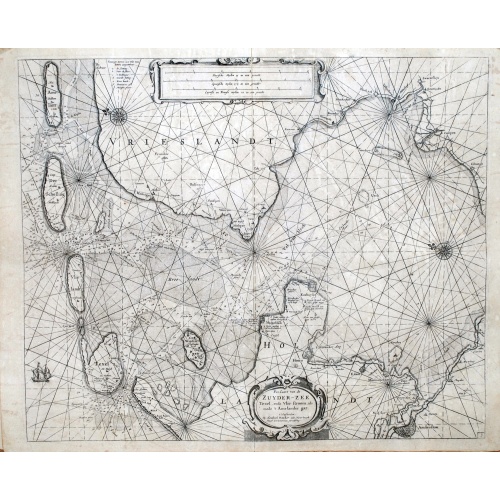
Pas-Caart van de ZUYDER-ZEE, Texel ende Vlie-stroom.als mede 't Amelander gat (Hollandt/Vrieslandt)
An attractive chart of the Zuiderzee, now the inland water het IJselmeer.HOLLANDT / VRIESLANDTPas-Caart van de Zuyder-Zee, Texel ende Vlie-stroom.als mede 't Amelander gat (1665)
€1.500
Maker : DONCKER, Hendrick
Place : Amsterdam
Date : c. 1665
![[Lot of 8 maps and prints] Norvegiae Maritimae ab Elf-burgo ad Dronten / Pascaert van Noorwegen streckende van Elf-burg tot Dronten.](/uploads/cache/84130-500x500.jpg)
[Lot of 8 maps and prints] Norvegiae Maritimae ab Elf-burgo ad Dronten / Pascaert van Noorwegen streckende van Elf-burg tot Dronten.
Norvegiae Maritimae ab Elf-burgo ad Dronten / Pascaert van Noorwegen streckende van Elf-burg tot Dronten.Frederick de Wit's fine sea chart of southern Norway. An attractive sea chart of southern Norway and Sweden, richly embellished with a stunning large decorative title cartouche, showing the drying of cod. A lot of 8 maps including:-Carte du Detroit de Waeigats ou de Nassau 1758 -Partie de la Mer Glaciale 1758 -RVGIA VSEDO MIAE ET IVLINAE -Carte du Spits-Berg 1758 -Carte Des Pais Habites par�...
€900
Maker : DE WIT, Frederick.
Place : Amsterdam
Date : 1675

Paskaerte van het inkoomen van de MAES, Tot aen 't Eylandt Roosenburgh als mede 't Inkoomen van 't Goereesche Gat.. / Pascaert van 't Eylandt Roosenburg door de Oude en Nieuwe Maes....
A very attractive sea chart on two sheets of the mouth of the river Maas. The left sheet shows Dordrecht, Rotterdam and the fortress at Willemstad. Rghthand sheet depicts "Hook of Holland" showing Goeree and Brielle. Elaborate sea-themed cartouches and Poseidon vignette on the western sheet. Both scale cartouches decorated with cornucopia. Each include rhumb lines and a compass rose. Nicely detailed depths and banks. Set of 2 charts when joined 110 x 49 cm.- Paskaerte van het Inkoomen van de...
€1.500
Maker : KEULEN, J. van.
Place : Amsterdam
Date : 1680
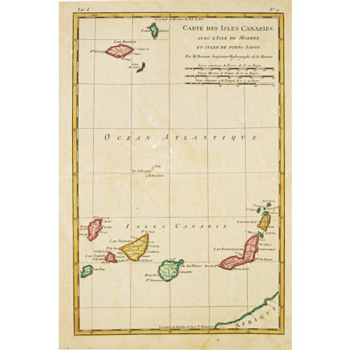
Nieuwe Pascaert van de Kust van Maroca en Zanhaga. . .
A very fine sea chart of the west coast of Morocco between C.Cantin tot C.Bajador and the Canary Islands, Lanzerote and Fuerteventura. With a very large decorative title-cartouche and an inset depicting Porto de Nao en Po. de Cavallos on Lanzerote. Rhumb lines. Johannes van Keulen is the founder of the successful van Keulen firm that published charts, pilot guides and sea-atlases for over 2 centuries. In 1680, he published his immensely popular 'Zee Atlas of te Water Werelt'.
€600
Maker : VAN KEULEN, Johannes.
Place : Amsterdam
Date : ca 1685

Nieuwe Paskaert van de Kust van HOLLANDT - Tussen Texel en de Maes.
Nieuwe Paskaert van de Kust van Hollandt Tussen Texel en de Maes. A very attractive sea chart off the coast of Holland by Johannes van Keulen with a pair of decorative cartouches, ships sailing off the coast, rhumb lines, compass rose etc. Van Keulen was the founder of the successful van Keulen firm that published charts, pilot guides and sea-atlases for over 2 centuries. In 1680, he published his immensely popular 'Zee Atlas ofte Water Werelt'.
€500
Maker : van Keulen, J.
Place : Amsterdam
Date : ca 1685
![[Lot of 15 maps/plans of northern France] Gouvernement d' Orleans et la Generalite divisee en ses Elections.](/uploads/cache/16682-500x500.jpg)
[Lot of 15 maps/plans of northern France] Gouvernement d' Orleans et la Generalite divisee en ses Elections.
Alexis-Hubert Jaillot (1632-1712), French cartographer. He joined the Sanson heirs and redrew Nicolas Sanson's maps on a larger scale. 'Atlas Nouveau' (1674), sea-atlas ' Le Neptune François' (1693).An attractive large-format map depicting Orleans and vincinity. Embellished with a large title-cartouche and a cartouche with scales.Newly engraved for the counterfeited edition of the ' Atlas Nouveau', published by Pieter Mortier in Amsterdam. Ref.: Pastoureau, Les Atlas Français XVIe-XVIIe Siècl...
€500
Maker : Jaillot, A.-H. / P. Mortier.
Place : Amsterdam
Date : 1693
![[Set of 2 maps of Caspian Sea.] Carte marine de la Mer Caspiene. Levee suivant les ordres de S.M. Czariene, P](/uploads/cache/86020-(1)-500x500.jpg)
[Set of 2 maps of Caspian Sea.] Carte marine de la Mer Caspiene. Levee suivant les ordres de S.M. Czariene, P
Guillaume de l' Isle (1675-1724), Royal Geographer, was the most influential cartographer of the first quarter of the 18th century. ' Atlas de Géographie' (1700-12), posthumous ' Atlas Nouveau' (1730). After the death of the widow of Pieter Mortier in 1719, the firm continued till 1778 as Covens & Mortier. They published numerous atlases and pocket atlases, using maps after de l' Isle and Jaillot.Two charts together depicting the Caspian Sea; the northern part of the Caspian Sea with insets dep...
€350
Maker : Guillaume Delisle
Place : Paris
Date : 1721
![[Lot of 10 maps] Carte Nouvelle de la Grande Tartary.](/uploads/cache/85969-500x500.jpg)
[Lot of 10 maps] Carte Nouvelle de la Grande Tartary.
Antique map of Asian Russia] Carte Nouvelle de la Grande Tartarie ou de l'Empire du Grand Cham. With 10 maps / views of Asian Russia- Carte Nouvelle de la Grande Tartarie ou de L’empire du Grand Cham (1719)- Baie de castries settee sur la cote orientale de tartarie (1797)- Carte du Kamtchatka Dressee et Gravée par Laurent (1757)- 2x Gezichten der kust van Asiën.- Gezichten der kust van Kamtchatka.- Carte de la Tartarie Occidentale, Pour servir à l'Histoire Générale (1749)- IImperium Rus...
€700
Maker : CHATELAIN, H.
Place : Amsterdam
Date : 1720 - 1730
![[ Lot of 2 maps of the Asian continent]Asia Divisa in Imperia, Regna & Status in que distribuitur, ad usum serenissimi Burgundiae Ducis](/uploads/cache/86164-500x500.jpg)
[ Lot of 2 maps of the Asian continent]Asia Divisa in Imperia, Regna & Status in que distribuitur, ad usum serenissimi Burgundiae Ducis
Fine map of the Asian continent published in Amsterdam by R. and J. Ottens, after H. Jaillot.Together with a map by Claude Buy de Mornas (d. 1783), géographe du Roi (1764). He published Atlas Méthodique et Elémentaire de Géographie et d' Histoire, 1761, Atlas Historique et Géographique, in 1762. All within an elaborate and very decorative border. A very fine item.[Lot of 2 maps] of the Asian continent.-Asie-Asia Divisa in Imperia, Regna & Status in que distribuitur, ad usum serenissimi Bu...
€400
Maker : OTTENS, R. and J. / Buy de Mornas, Cl.
Place : Amsterdam
Date : 1740
![[Lot of 5 maps of the mouth of the Gironde river] Carte des Entrees et Cours de la Gironde](/uploads/cache/86010-500x500.jpg)
[Lot of 5 maps of the mouth of the Gironde river] Carte des Entrees et Cours de la Gironde
A large sea chart of the mouth and course of the Gironde river as far inland as Bordeaux. Decorated with three cartouches.Jacques Nicolas Bellin (1702-720) was the most important French hydrographer of the 18th century. Sea-atlas 'Hydrographique Français' , 1756-65, atlas to accompany Prévost d' Exile's ' Histoire. des Voyages', 1738-75. A lot of 5 maps of the mouth of the Gironde river.- Carte des Entrees et Cours de la Gironde ((96x65 cm)- Carte du Gouvernent de Guyenne et Gascogne- Gou...
€350
Maker : BELLIN, J. N.
Place : Paris
Date : c. 1740
![[Lot of 3 maps] Carte de la Souveraineté de NEUCHATEL et VALLANGIN. Plus Mercator's and Blaeu's maps of the Wiflispurgergou]](/uploads/cache/85967-500x500.jpg)
[Lot of 3 maps] Carte de la Souveraineté de NEUCHATEL et VALLANGIN. Plus Mercator's and Blaeu's maps of the Wiflispurgergou]
Map of the lake of Neuchatel by Covens & Mortier. After the death of the widow of Pieter Mortier in 1719, the firm continued till 1778 as Covens & Mortier. They published numerous atlases and pocket atlases, using maps after de l' Isle and Map of the lake of Neuchatel.Plus Mercator's and Blaeu's maps of the Wiflispurgergou. [Lot of 3 maps]- Carte de la Souveraineté de NEUCHATEL et VALLANGIN- das WIFLISPUR-Gergow- Das WIFLISPUR-Gergow Blaeu 1610
€350
Maker : COVENS, J. / MORTIER, C.
Place : Amsterdam
Date : c. 1745
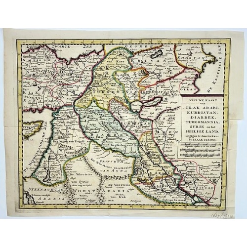
Irak, Arabi, Kurdistan, Diarbek, Turkomania, Syrie en het Heilige Land.
Isaak Tirion's map of the Near East. His 'Nieuwe en beknopte handatlas' saw 6 editions between before 1740 and after 1784. Also the 'Atlas van de Nederlandse Provintien' (1739-57) and ' Atlas van Zeeland' (1760).
€350
Maker : TIRION, Isaak.
Place : Amsterdam
Date : ca. 1750
![[Lot of 13 prints of the Chinese court] Habillement de l' Empereur dela Chine & des Dames de son Palais aves quel...](/uploads/cache/IMG_08451-500x500.jpg)
[Lot of 13 prints of the Chinese court] Habillement de l' Empereur dela Chine & des Dames de son Palais aves quel...
Prints of the Chinese court.[Lot of 13 prints]- Salle Imperiale De L'Audience, tiree de Nieuhof (1760)- Pagodes ou Statues; Miniso ou la Volupté (1749- Pagodes ou statues du temple. 1. Un defenseur de la patrie.- Mandians vacabonds / Autres mandais - Pagodes ou statues du temple- Salle Imperiale de l'Audience tiree de Nieuhof- Laboureurs (1750)- Cour du Grand Mogol- l'ambassadeur conduit a l’audience- Le Grand Throne Imperial.- Mandians Vagabonds. Autres Mandians / Zwervende Schooije...
€400
Maker : BELLIN, J.N.
Place : Amsterdam
Date : 1750