ID: 190
Open
Listing ID: #190 has been added to your wishlist.
![[Lot of 10 maps] Carte Nouvelle de la Grande Tartary.](/uploads/85969.jpg)
[Lot of 10 maps] Carte Nouvelle de la Grande Tartary.
BuyNow for €700
- Maker :
- CHATELAIN, H.
- Place :
- Amsterdam
- Date :
- 1720 - 1730
- Color :
- Colored
- Height mm.:
- 400
- Width mm.:
- 508
- Condition :
- In very good condition.
- Bibliography :
- -
- Seller's ref. :
- 85969
This item is offered by Papyro
See other Items from this seller- Postage
-
Standard Shipping
€25 to Netherlands
- Select Country
- Zip/Post Code
- Quantity
€700
Description
Antique map of Asian Russia] Carte Nouvelle de la Grande Tartarie ou de l'Empire du Grand Cham.
With 10 maps / views of Asian Russia
- Carte Nouvelle de la Grande Tartarie ou de L’empire du Grand Cham (1719)
- Baie de castries settee sur la cote orientale de tartarie (1797)
- Carte du Kamtchatka Dressee et Gravée par Laurent (1757)
- 2x Gezichten der kust van Asiën.
- Gezichten der kust van Kamtchatka.
- Carte de la Tartarie Occidentale, Pour servir à l'Histoire Générale (1749)
- IImperium Russiae Magnae juxta recentissimas observat mappa geographica accuratissime (1740)
- La grande Tartarie (1683) - Ocean Septentri Onal
- Naaukeurige Kaart Van Tartaryen, Soo als dat door W De Rubruquis doorreyst is. In 't Jar 1253 (1706)
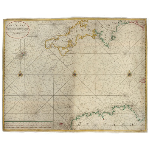
Nieuwe Paskaart van het Westerlykste Gedeelte van HET KANAAL strekkende aan de ENGELSCHE KUST van Poortland tot de Sorlinges. . .
Nieuwe Paskaart van het Westerlykste Gedeelte van HET KANAAL strekkende aan de ENGELSCHE KUST van Poortland tot de Sorlinges en aan de Fransche kust van het Eylandt Guernsey tot Heysandt. Ioannes van Keulen A RARE and decorative chart of the Channel between England and France. Decorated with a fine title cartouche: Nieuwe Paskaart van het Westerlykste Gedeelte van HET KANAAL strekkende aan de ENGELSCHE KUST van Poortland tot de Sorlinges en aan de Fransche Kust van het Eylandt Guernsey tot He...
€900
Maker : VAN KEULEN, J.
Place : Amsterdam
Date : 1760
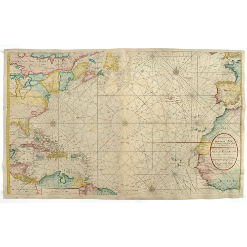
Nieuwe Wassende Graade Zee Kaart over de Spaanse Zee Vant Kanaal tot 't Eyland Cuba In Westindia.
Rare two-sheet blue-back sea chart of the Atlantic and Eastern part of North America., published by Gerard Van Keulen. The map extends from the latitude of Newfoundland and the English Channel in the north to the Equator in the south.In North America, most of the Great Lakes are shown and a large lake (Apalache Lac) in South Carolina. Florida is presented in a triangular shape.Florida is shown in a triangular model, with large islands forming the tip and numerous soundings along the coast. The ...
€2.500
Maker : VAN KEULEN, G.
Place : Amsterdam
Date : ca. 1728-1751
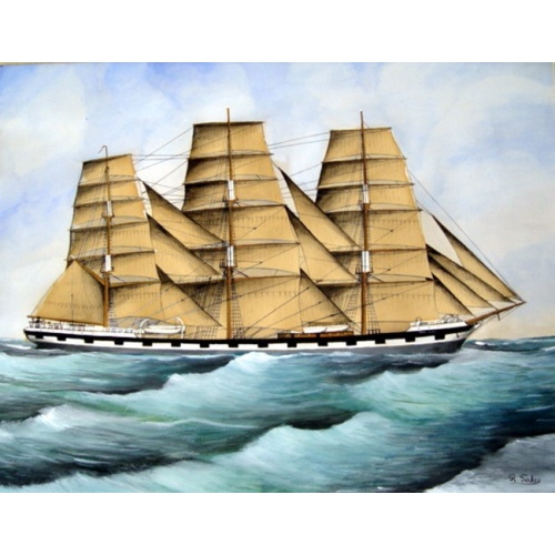
Original Maritime painting of the 'Cape Horn' , a so-called captain's ship drawing by R. Takes
A fine example of a so-called 'captain's portrait' of a clipper-ship under full sail. The name of the ship at the bow reads "Cape Horn" Signed in the lower right corner: R.Takes.
€750
Maker : TAKES, R.
Place : unknown
Date : c. 1850
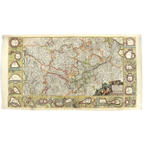
![[Lot of 14 maps of Germany] Nova Totius Germaniae Descriptio.](/uploads/cache/86021-500x500.jpg)
[Lot of 14 maps of Germany] Nova Totius Germaniae Descriptio.
Willem Blaeu, founder of the famous publishing firm. Originally publishing pilot-guides, he issued his first atlas, 'Atlantis Appendix', in 1630, followed by his "Theatrum Orbis Terrarum" or "Novus Atlas" in 1635.Willem Blaeu's map of Germany. From the French edition of Willem Blaeu's atlas "Theatrum". With 13 other map of general Germany by Tirion, Bachienne and Bonne.[Lot of 14 maps]- Nova Totius Germaniae Descriptio. Blaeu 1634- Nieuwe kaart van Duitsland verdeelt in zyn Thien Kre...
€500
Maker : BLAEU, W.
Place : Amsterdam
Date : 1635
Postage & Shipping
-
Item Location
Terms and conditions - Item Location
- Amsterdam, , Netherlands
- Ships To
- Worldwide
- Pick-ups
- Buyer can pick-up
This item is owned and offered by the seller Papyro - All items are available for immediate sale, offered subject to prior sale.
Invoices are created by the seller by using our shopping cart or be prepared by the seller the day following the order and are emailed to you.
Items offeres by different sellers are invoiced separately.
Shipping fees are extra. The buyer is responsible for all applicable taxes, including any VAT, customs clearance, import duties, or equivalent costs arriving at the customer's home border. Payment is due on receipt of the invoice. The item(s) are shipped as soon as possible after receipt of your payment.
Before buying please read the complete Terms Conditions of Sale.
- Payment Methods
- Visa, Mastercard, Bank Transfer, PayPal
- Returns Accepted
- No
Post Message
Feel free to ask the seller a question. Please note that the seller could be located in an area with a different time zone. Our seller will do their best to respond within 24 hours.Post your message below.
Sign in to ask the seller a question.
![[Lot of 10 maps] Carte Nouvelle de la Grande Tartary.](/uploads/cache/85969-500x500.jpg)