
ID: 197
Open
![[Lot of 14 maps of Germany] Nova Totius Germaniae Descriptio.](/uploads/86021.jpg)
[Lot of 14 maps of Germany] Nova Totius Germaniae Descriptio.
BuyNow for €500
- Maker :
- BLAEU, W.
- Place :
- Amsterdam
- Date :
- 1635
- Color :
- Colored
- Height mm.:
- 300
- Width mm.:
- 490
- Condition :
- A tear in lower center fold expertly restored, otherwise good condition.
- Bibliography :
- -
- Seller's ref. :
- 86021
This item is offered by Papyro
See other Items from this seller- Postage
-
Standard Shipping
€25 to Netherlands
- Select Country
- Zip/Post Code
- Quantity
€500
Description
Willem Blaeu, founder of the famous publishing firm. Originally publishing pilot-guides, he issued his first atlas, 'Atlantis Appendix', in 1630, followed by his "Theatrum Orbis Terrarum" or "Novus Atlas" in 1635.Willem Blaeu's map of Germany. From the French edition of Willem Blaeu's atlas "Theatrum".
With 13 other map of general Germany by Tirion, Bachienne and Bonne.
[Lot of 14 maps]
- Nova Totius Germaniae Descriptio. Blaeu 1634
- Nieuwe kaart van Duitsland verdeelt in zyn Thien Kreitzen. Tirion 1744
- L' Allemagne Divisee En Tous Ses Cercles, 1766
- Analyse: L' Allemagne Divisee En Tous Ses Cercles, 1766
- Germania Veteris Typus 1683
- Allemagne. Par N. Sanson le fils Geographe du Roy. 1648
- Allemagne. Par N. Sanson le Fils Géographe du Roy 1740
- Nieuwe en Naauwkeurige Kaart van Duitschland, verdeeld in deszelvs Kreitsen. W. Albert 1778
- l'allemagna venezia 1790 (pag 124)
- Germania.
- L'Allemagne, la Bohème, et la Hongrie, avec une partie de la Pologne. 1780
- Nieuwe en Nauwkeurige kaart der noord-westelijke delen Duitsland . Eman Bowen
- Germaniae Magnae Vindeliciae, Rhaetiae et Norici Tabula Geographica 1783
- Germaniae Veteris typus. published 1595
![[Lot of 15 maps/plans of northern France] Gouvernement d' Orleans et la Generalite divisee en ses Elections.](/uploads/cache/16682-500x500.jpg)
[Lot of 15 maps/plans of northern France] Gouvernement d' Orleans et la Generalite divisee en ses Elections.
Alexis-Hubert Jaillot (1632-1712), French cartographer. He joined the Sanson heirs and redrew Nicolas Sanson's maps on a larger scale. 'Atlas Nouveau' (1674), sea-atlas ' Le Neptune François' (1693).An attractive large-format map depicting Orleans and vincinity. Embellished with a large title-cartouche and a cartouche with scales.Newly engraved for the counterfeited edition of the ' Atlas Nouveau', published by Pieter Mortier in Amsterdam. Ref.: Pastoureau, Les Atlas Français XVIe-XVIIe Siècl...
€500
Maker : Jaillot, A.-H. / P. Mortier.
Place : Amsterdam
Date : 1693
![[Lot of 17 maps] L' ISLE DE FRANCE Pariensis agri descriptio. Francois de la Hoeye fecit, Jean le Clerc excud.](/uploads/cache/86212-500x500.jpg)
[Lot of 17 maps] L' ISLE DE FRANCE Pariensis agri descriptio. Francois de la Hoeye fecit, Jean le Clerc excud.
The map of Ile de France which Jean Leclerc added in his re-issue of Maurice Bouguereau's atlas 'Theatre Francois' , as ' La Theatre geographique de France' in 1619. An uncommon and decorative map.[Lot of 17] maps of F R A N C E- L'Isle de France, Parisiensis agri descrip(tio). - Gouvernemens de Picardie, de Boulonnois, et d’Artois (1768)- V. Descrittione del Regno della Gallia (1598)-La France Divisée en ses quarante Gouvernamens Généraux et Militaire.- - Topographia aug. Turon. duca...
€1.000
Maker : Jean Leclerc
Place : Paris
Date : 1619
![[The Americas] AMERIQUE](/uploads/cache/86276-500x500.jpg)
[The Americas] AMERIQUE
A map depicting both the Americas. With on both sides a descriptionary text. All within an elaborate and very decorative border. Claude Buy de Mornas (d. 1783), géographe du roi (1764). Atlas Méthodique et Elémentaire de Géographie et d' Histoire, 1761, Atlas Historique et Géographique, 1762.
€350
Maker : BUY DE MORNAS, Cl.
Place : Paris
Date : 1761
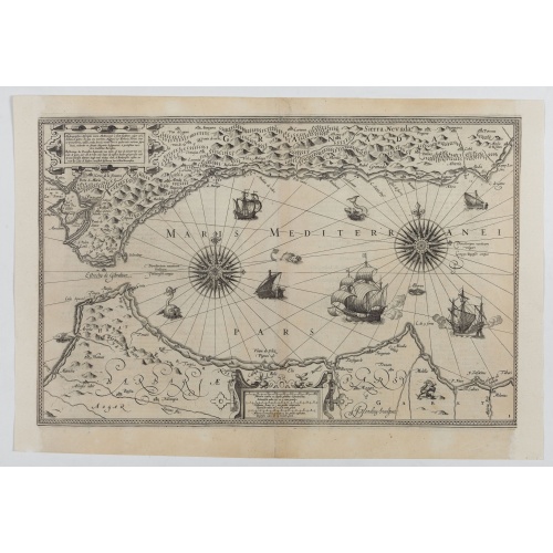
Hydrograhica descriptio
This very rare chart is important as the first printed sea chart of the Mediterranean coast of Spain, Gibraltar, also depicting the northern coast of Marocco.Willem Barentsz (1560-1597) was a famous pilot, discoverer and cartographer. Author of 'Nieuwe Beschrhryvinghe ende caertboeck van de Midlantsche Zee', the first printed pilot-guide of the Mediterranean. It is considered the supplement of Waghenaer's 'Spieghel der Zeevaerdt' for the Mediterranean waters.
€4.000
Maker : BARENDTSZ, W.
Place : Amsterdam, W. Blaeu
Date : 1612
Postage & Shipping
-
Item Location
Terms and conditions - Item Location
- Amsterdam, , Netherlands
- Ships To
- Worldwide
- Pick-ups
- Buyer can pick-up
This item is owned and offered by the seller Papyro - All items are available for immediate sale, offered subject to prior sale.
Invoices are created by the seller by using our shopping cart or be prepared by the seller the day following the order and are emailed to you.
Items offeres by different sellers are invoiced separately.
Shipping fees are extra. The buyer is responsible for all applicable taxes, including any VAT, customs clearance, import duties, or equivalent costs arriving at the customer's home border. Payment is due on receipt of the invoice. The item(s) are shipped as soon as possible after receipt of your payment.
Before buying please read the complete Terms Conditions of Sale.
- Payment Methods
- Visa, Mastercard, Bank Transfer, PayPal
- Returns Accepted
- No
Post Message
Feel free to ask the seller a question. Please note that the seller could be located in an area with a different time zone. Our seller will do their best to respond within 24 hours.Post your message below.
Sign in to ask the seller a question.
![[Lot of 14 maps of Germany] Nova Totius Germaniae Descriptio.](/uploads/cache/86021-500x500.jpg)