ID: 176
Open
Listing ID: #176 has been added to your wishlist.
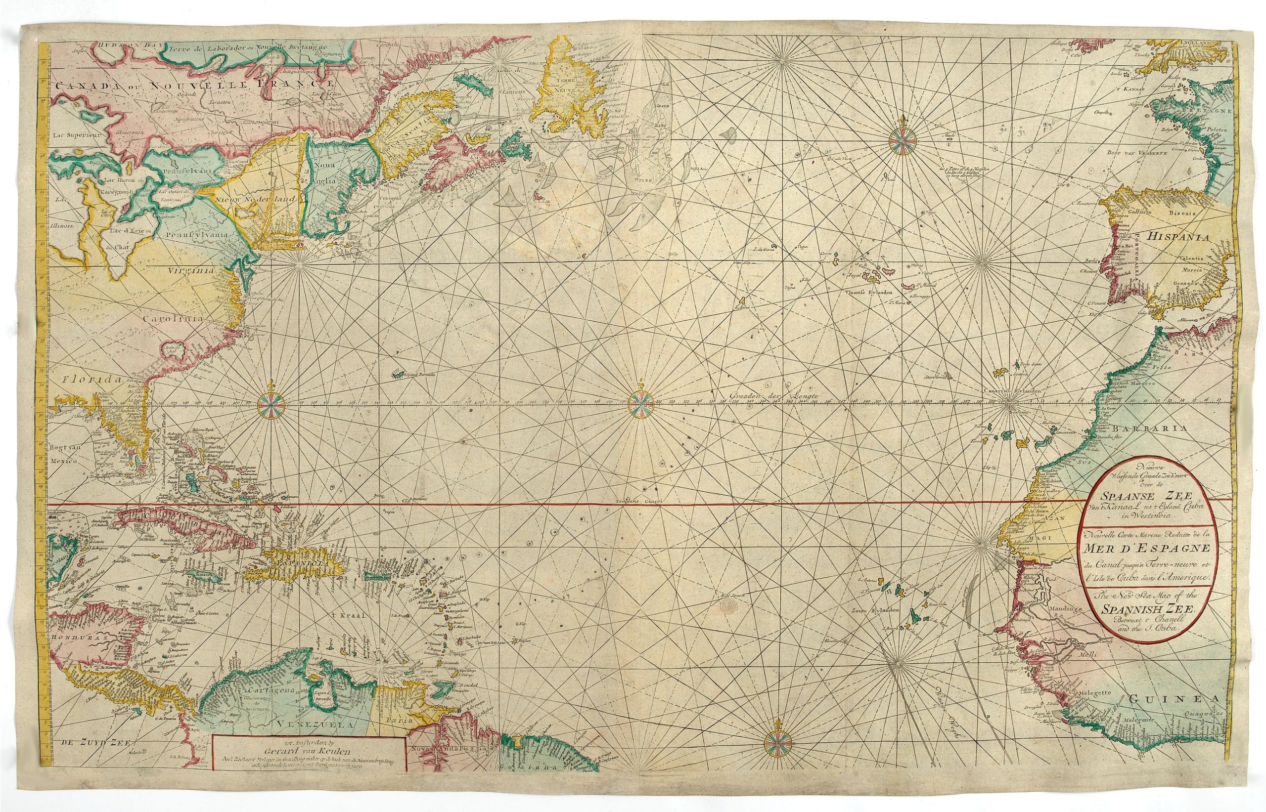
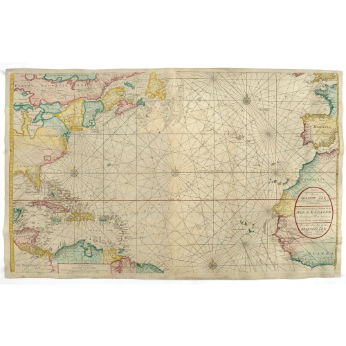
Nieuwe Wassende Graade Zee Kaart over de Spaanse Zee Vant Kanaal tot 't Eyland Cuba In Westindia.
BuyNow for €2.500
- Maker :
- VAN KEULEN, G.
- Place :
- Amsterdam
- Date :
- ca. 1728-1751
- Color :
- Colored
- Height mm.:
- 591
- Width mm.:
- 995
- Condition :
- In very good condition. Printed on heavy paper. Several foldings as issued. Laid down on blue paper.
- Bibliography :
- -
- Seller's ref. :
- 48584
This item is offered by Papyro
See other Items from this seller- Postage
-
Standard Shipping
€25 to Netherlands
- Select Country
- Zip/Post Code
- Quantity
€2.500
Description
Rare two-sheet blue-back sea chart of the Atlantic and Eastern part of North America., published by Gerard Van Keulen. The map extends from the latitude of Newfoundland and the English Channel in the north to the Equator in the south.In North America, most of the Great Lakes are shown and a large lake (Apalache Lac) in South Carolina. Florida is presented in a triangular shape.
Florida is shown in a triangular model, with large islands forming the tip and numerous soundings along the coast. The coasts of Britain, France, Spain, and western Africa are shown in the eastern hemisphere.
The chart was engraved by Luggert van Anse, active 1690-1716. From: Nieuwe groote lightende Zee-Fakkel, part IV, editions from 1728 to 1744 and an untitled atlas of 21 charts, attributed to Gerard van Keulen.
The chart is one of the new larger format sea charts added to the Zee-Fakkel first published in 1728.
Read more about Van Keulen dynasties. [+]
Blueback charts
Blueback nautical charts began appearing in London in the late 18th century and are known for their distinctive blue paper backing.
The backing, a commonly available blue manila paper was a practical way to reinforce the chart. Publishers who published blueback charts are Mount and Page, Robert Sayer, John Hamilton Moore, Robert Blachford, James Imray, William Heather, John William Norie, Charles Wilson, David Steel, R. H. Laurie, and John Hobbs, among others.
Bluebacks became so popular that chart makers outside of England, including America, Netherlands, Scandinavia, France, Germany, Russia, and Spain produced them until the late 19th century.
Read more about Blue-back charts [+]
![[Lot of 6 maps / prints] Schets van de Donkere Baai in Nieuw Zeeland 1773.](/uploads/cache/86004-500x500.jpg)
[Lot of 6 maps / prints] Schets van de Donkere Baai in Nieuw Zeeland 1773.
A map of Dusky Bay, visited by James Cook in 1773. From a Dutch edition of ‘Cook's voyages'. Schets van de Donkere Baai in Nieuw Zeeland 1773. Nicolas Bellin's map of the Marianas islands with an inset map of Guam. A view of Easter Island, of men of Hapahee in a fighting contest and a plan of a Tahitian war proha. Together 6 maps / views of the Pacific Ocean.Captain James Cook (1728-79), explorer, circumnavigator and hydrographer. Three voyages, 1768-71, 1772-75 and 1776-79. From 1778 on p...
€350
Maker : James Cook
Place : London
Date : ca. 1790
![[Lot of 3] Celestial chart depicting astronomical division of the earth.](/uploads/cache/84235-500x500.jpg)
[Lot of 3] Celestial chart depicting astronomical division of the earth.
A chart depicting the astronomical division of the earth. With on both sides a descriptionary text. All within an elaborate and very decorative border. A very fine item.Claude Buy de Mornas (d. 1783), géographe du roi (1764). Atlas Méthodique et Elémentaire de Géographie et d' Histoire, 1761, Atlas Historique et Géographique, 1762. A chart depicting the astronomical division of the earth. With on both sides a descriptionary text. All within an elaborate and very decorative border. A very fi...
€250
Maker : BUY DE MORNAS, C.
Place : Paris, L.C. Desnos
Date : 1761.
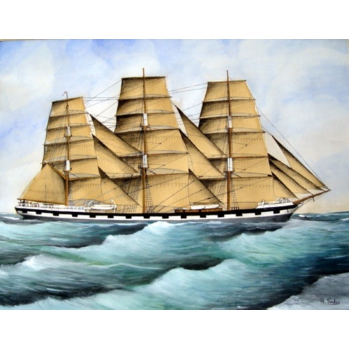
Original Maritime painting of the 'Cape Horn' , a so-called captain's ship drawing by R. Takes
A fine example of a so-called 'captain's portrait' of a clipper-ship under full sail. The name of the ship at the bow reads "Cape Horn" Signed in the lower right corner: R.Takes.
€750
Maker : TAKES, R.
Place : unknown
Date : c. 1850
![[Lot of 7 Flower prints] Talauma mutabilis. flower Talauma mutabilis from 'FLORA MALESIANA' Arckenhausen del. / Hutz Lith.](/uploads/cache/85382-500x500.jpg)
[Lot of 7 Flower prints] Talauma mutabilis. flower Talauma mutabilis from 'FLORA MALESIANA' Arckenhausen del. / Hutz Lith.
The flower Talauma mutabilis from 'FLORA MALESIANA'. Talauma mutabilis by Karl Ludwig von Blume (9 June 1796, Braunschweig – 3 February 1862, Leiden) was a German-Dutch botanist. (3454)Lot of 7 flower prints.- Talauma mutabilis - Sobralia Macrantha- Détails de la liane femelle du Chili- Liane femelle du Chili- Détails de la lianne màle du Chili- Dianthus sinensis heddewigii- Dianthus sinensis laciniatus
€300
Maker : BLUME, Carl Ludwig. von
Place : Germany
Date : 1829
Postage & Shipping
-
Item Location
Terms and conditions - Item Location
- Amsterdam, , Netherlands
- Ships To
- Worldwide
- Pick-ups
- Buyer can pick-up
This item is owned and offered by the seller Papyro - All items are available for immediate sale, offered subject to prior sale.
Invoices are created by the seller by using our shopping cart or be prepared by the seller the day following the order and are emailed to you.
Items offeres by different sellers are invoiced separately.
Shipping fees are extra. The buyer is responsible for all applicable taxes, including any VAT, customs clearance, import duties, or equivalent costs arriving at the customer's home border. Payment is due on receipt of the invoice. The item(s) are shipped as soon as possible after receipt of your payment.
Before buying please read the complete Terms Conditions of Sale.
- Payment Methods
- Visa, Mastercard, Bank Transfer, PayPal
- Returns Accepted
- No
Post Message
Feel free to ask the seller a question. Please note that the seller could be located in an area with a different time zone. Our seller will do their best to respond within 24 hours.Post your message below.
Sign in to ask the seller a question.