ID: 183
Open
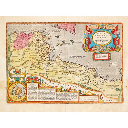
AFRICAE PROPRIAE TABULA In qua, Punica regna vides; Tyrios, et Agenoris / urbem.
BuyNow for Ōé¼350
- Maker :
- ORTELIUS, A.
- Place :
- Antwerp
- Date :
- 1590
- Color :
- Colored.
- Height mm.:
- 335
- Width mm.:
- 487
- Condition :
- In good condition. Some light foxing, staining and age toning. Bold coloring. Some restoration to parts of the centrefold.
- Bibliography :
- -
- Seller's ref. :
- 85163
This item is offered by Papyro
See other Items from this seller- Postage
-
Standard Shipping
Ōé¼25 to Netherlands
- Select Country
- Zip/Post Code
- Quantity
Ōé¼350
Description
AFRICAE PROPRIAE TABULA In qua, Punica regna vides; Tyrios, et Agenoris / urbem. Antique map of North Africa with Carthage. A very decorative map of North Africa with an inset with the town of Carthage. From the rare Spanish edition of Abraham OrteliusŌĆÖ ŌĆśTheatrum Orbis TerrarumŌĆÖ, published by Vrientius.
Abraham Ortelius(1527-98), Dutch cartographer and publisher of the first modern atlas, ' Theatrum Orbis Terrarum' in 1570. Editions till 1612. Also an atlas of ancient cartography, the 'Parergon' and a pocket atlas, the 'Epitome'.

A Map of the most Inhabited part of New England containing the Provinces of Massachusetts Bay and New Hampshire, with the Colonies of Connecticut and Rhode Island.
A copper engraving in four sheets, published in Georges Louis Le Rouge, in his "Atlas Ameriqua in Septentrional Contenant les details des differentes provinces, de ce vaste continent, traduit des cartes lev├®es par ordre du Gouvernement Britannique". This is a very close copy of the second edition, the second issue of the Jefferys-Green map, even down to the spelling, in the statement of sources, of Connecticut with 'k's (but translated into French). The title cartouche is also a straight copy, ...
Ōé¼4.000
Maker : LE ROUGE, G. L.
Place : Paris, 1777
Date : Paris, 1777
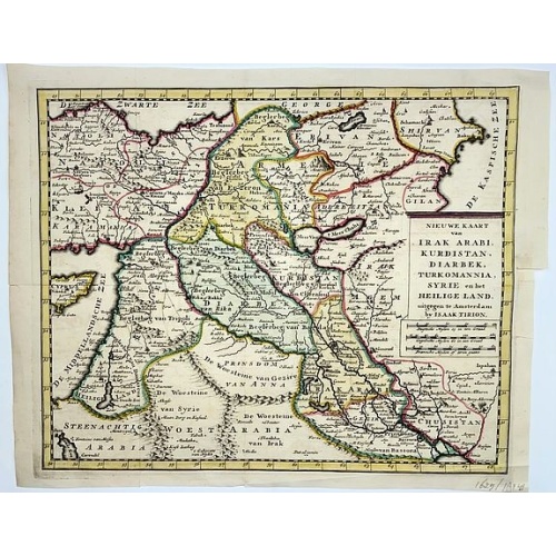
Irak, Arabi, Kurdistan, Diarbek, Turkomania, Syrie en het Heilige Land.
Isaak Tirion's map of the Near East. His 'Nieuwe en beknopte handatlas' saw 6 editions between before 1740 and after 1784. Also the 'Atlas van de Nederlandse Provintien' (1739-57) and ' Atlas van Zeeland' (1760).
Ōé¼350
Maker : TIRION, Isaak.
Place : Amsterdam
Date : ca. 1750
![[Lot of 5 maps] Kaart van de noord-west kust van Amerika en de noord-oost kust van Asia.](/uploads/cache/19136-500x500.jpg)
[Lot of 5 maps] Kaart van de noord-west kust van Amerika en de noord-oost kust van Asia.
- Kaart van de noord-west kust van Amerika en de noord-oost kust van Asia. Opgenoomen in de Jaaren 1778 en 1779.Captain James Cook (1728-79), explorer, circumnavigator and hydrographer. Three voyages, 1768-71, 1772-75 and 1776-79. From 1778 on printed editions of ' Captain Cook's Travels' appeared in English, Italian, French and Dutch east coast. From a Dutch edition of Cook's voyages'.- Carte d'une Partie DE L'AMERIQUE SEPTRIONALE qui comprendles POSSESSIONA ANGLAISES.┬ĀThis map depicts colonia...
Ōé¼300
Maker : COOK, J.
Place : Leiden
Date : 1795-1803
-500x500.jpg)
Geographie Universelle dite de Crozat.
A nice geographical dictionair with maps of the world and the continents and┬Ā maps of European countries. Lacks the maps of France and of the Turkish empire.
Ōé¼280
Maker : Crozat.
Place : Paris
Date : 1823
Postage & Shipping
-
Item Location
Terms and conditions - Item Location
- Amsterdam, , Netherlands
- Ships To
- Worldwide
- Pick-ups
- Buyer can pick-up
This item is owned and offered by the seller Papyro - All items are available for immediate sale, offered subject to prior sale.
Invoices are created by the seller by using our shopping cart or be prepared by the seller the day following the order and are emailed to you.
Items offeres by different sellers are invoiced separately.
Shipping fees are extra. The buyer is responsible for all applicable taxes, including any VAT, customs clearance, import duties, or equivalent costs arriving at the customer's home border. Payment is due on receipt of the invoice. The item(s) are shipped as soon as possible after receipt of your payment.
Before buying please read the complete Terms Conditions of Sale.
- Payment Methods
- Visa, Mastercard, Bank Transfer, PayPal
- Returns Accepted
- No
Post Message
Feel free to ask the seller a question. Please note that the seller could be located in an area with a different time zone. Our seller will do their best to respond within 24 hours.Post your message below.
Sign in to ask the seller a question.