
ID: 174
Open
Listing ID: #174 has been added to your wishlist.
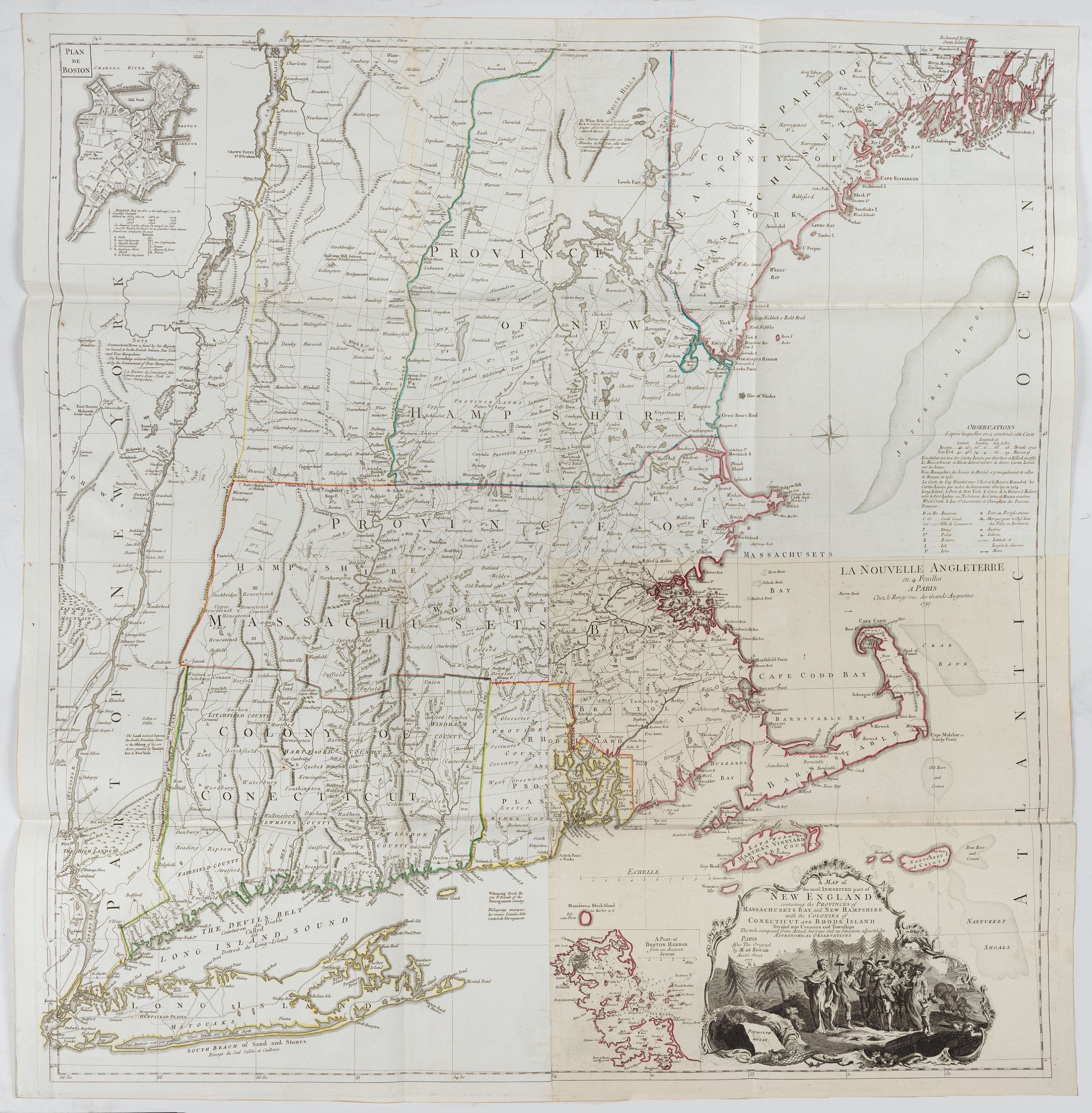
A Map of the most Inhabited part of New England containing the Provinces of Massachusetts Bay and New Hampshire, with the Colonies of Connecticut and Rhode Island.
BuyNow for €4.000
- Maker :
- LE ROUGE, G. L.
- Place :
- Paris, 1777
- Date :
- Paris, 1777
- Color :
- Original out line color
- Height mm.:
- 1011
- Width mm.:
- 970
- Condition :
- Strong impression, apart from a small restored tear in the double centerfold, in mint condition.
- Bibliography :
- -
- Seller's ref. :
- 20806
This item is offered by Papyro
See other Items from this seller- Postage
-
Standard Shipping
€25 to Netherlands
- Select Country
- Zip/Post Code
- Quantity
€4.000
Description
A copper engraving in four sheets, published in Georges Louis Le Rouge, in his "Atlas Ameriqua in Septentrional Contenant les details des differentes provinces, de ce vaste continent, traduit des cartes levées par ordre du Gouvernement Britannique".This is a very close copy of the second edition, the second issue of the Jefferys-Green map, even down to the spelling, in the statement of sources, of Connecticut with 'k's (but translated into French). The title cartouche is also a straight copy, but the image was reversed in the process. Both insets are included.

Paskaerte van het inkoomen van de MAES, Tot aen 't Eylandt Roosenburgh als mede 't Inkoomen van 't Goereesche Gat.. / Pascaert van 't Eylandt Roosenburg door de Oude en Nieuwe Maes....
A very attractive sea chart on two sheets of the mouth of the river Maas. The left sheet shows Dordrecht, Rotterdam and the fortress at Willemstad. Rghthand sheet depicts "Hook of Holland" showing Goeree and Brielle. Elaborate sea-themed cartouches and Poseidon vignette on the western sheet. Both scale cartouches decorated with cornucopia. Each include rhumb lines and a compass rose. Nicely detailed depths and banks. Set of 2 charts when joined 110 x 49 cm.- Paskaerte van het Inkoomen van de...
€1.500
Maker : KEULEN, J. van.
Place : Amsterdam
Date : 1680
![[Lot of 2 prints of Globes] La Sphere Terrestre / La Sphere Celeste.](/uploads/cache/84233-500x500.jpg)
[Lot of 2 prints of Globes] La Sphere Terrestre / La Sphere Celeste.
La Sphere Terrestre / La Sphere CelesteA set of two very fine prints of a Terrestrial Sphere and a celestial Sphere. With an description on both sides. All within an elaborate and very decorative border. Claude Buy de Mornas (d. 1783), géographe du roi (1764). Atlas Méthodique et Elémentaire de Géographie et d' Histoire, 1761, Atlas Historique et Géographique, 1762.[Lot of 2 prints]
€450
Maker : DE MORNAS, C.
Place : Paris, L.C. Desnos
Date : 1761
![[Lot of 6 Maps of Germany] PALATINATUS BAVARIAE.](/uploads/cache/19093-500x500.jpg)
[Lot of 6 Maps of Germany] PALATINATUS BAVARIAE.
[Lot of 6 Maps of Germany]- La Basse Partie Du Cercle Du Haut Rhein divisé en tous ses Estats et Souverainetés. 1696 - (875x580 mm)- Wirtenberg Ducatus (Hondius) 1638 - (494x415 mm)- Partie Orientale Du Palatinat et Eslectorat Du Rhein. Les Eveschés De Spire, De Wormes et Le Comté de Linange. 1692 - (565x430 mm)An attractive map of Bayern, embellished with a fine strapwork title-cartouche and a cartouche with scales.From the Latin, 1613 edition.Gerard Mercator (1512-94). His ' Atlas sive...
€700
Maker : MERCATOR, G. / HONDIUS, J.
Place : Amsterdam
Date : 1619

(Sea-chart of Catalunia, Languedoc, Provence, Cote d'Azur, Riviera, Corsica with Marseille, Cannes, Nice, Monaco.)
This very rare chart is important as the first printed sea chart of France's Mediterranean coast, also depicting Catalunya's northern coast, the Italian Cote d'Azur till San Remo and Corsica's west coast.Willem Barentsz (1560-1597) was a famous pilot, discoverer and cartographer. Author of 'Nieuwe Beschrhryvinghe ende caertboeck van de Midlantsche Zee', the first printed pilot-guide of the Mediterranean. It is considered the supplement of Waghenaer's 'Spieghel der Zeevaerdt' for the Mediterranea...
€4.000
Maker : BARENTSZ, Willem.
Place : Amsterdam
Date : 1607
Postage & Shipping
-
Item Location
Terms and conditions - Item Location
- Amsterdam, , Netherlands
- Ships To
- Worldwide
- Pick-ups
- Buyer can pick-up
This item is owned and offered by the seller Papyro - All items are available for immediate sale, offered subject to prior sale.
Invoices are created by the seller by using our shopping cart or be prepared by the seller the day following the order and are emailed to you.
Items offeres by different sellers are invoiced separately.
Shipping fees are extra. The buyer is responsible for all applicable taxes, including any VAT, customs clearance, import duties, or equivalent costs arriving at the customer's home border. Payment is due on receipt of the invoice. The item(s) are shipped as soon as possible after receipt of your payment.
Before buying please read the complete Terms Conditions of Sale.
- Payment Methods
- Visa, Mastercard, Bank Transfer, PayPal
- Returns Accepted
- No
Post Message
Feel free to ask the seller a question. Please note that the seller could be located in an area with a different time zone. Our seller will do their best to respond within 24 hours.Post your message below.
Sign in to ask the seller a question.
