
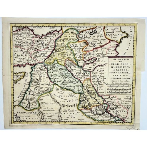
ID: 179
Open

Irak, Arabi, Kurdistan, Diarbek, Turkomania, Syrie en het Heilige Land.
BuyNow for €350
- Maker :
- TIRION, Isaak.
- Place :
- Amsterdam
- Date :
- ca. 1750
- Color :
- Original colors
- Height mm.:
- 280
- Width mm.:
- 340
- Condition :
- In good condition. Nicely colored. Extension to left-hand margin.
- Bibliography :
- -
- Seller's ref. :
- 83961
This item is offered by Papyro
See other Items from this seller- Postage
-
Standard Shipping
€25 to Netherlands
- Select Country
- Zip/Post Code
- Quantity
€350
Description
Isaak Tirion's map of the Near East. His 'Nieuwe en beknopte handatlas' saw 6 editions between before 1740 and after 1784. Also the 'Atlas van de Nederlandse Provintien' (1739-57) and ' Atlas van Zeeland' (1760).![[Lot of 6 maps / prints] Schets van de Donkere Baai in Nieuw Zeeland 1773.](/uploads/cache/86004-500x500.jpg)
[Lot of 6 maps / prints] Schets van de Donkere Baai in Nieuw Zeeland 1773.
A map of Dusky Bay, visited by James Cook in 1773. From a Dutch edition of ‘Cook's voyages'. Schets van de Donkere Baai in Nieuw Zeeland 1773. Nicolas Bellin's map of the Marianas islands with an inset map of Guam. A view of Easter Island, of men of Hapahee in a fighting contest and a plan of a Tahitian war proha. Together 6 maps / views of the Pacific Ocean.Captain James Cook (1728-79), explorer, circumnavigator and hydrographer. Three voyages, 1768-71, 1772-75 and 1776-79. From 1778 on p...
€350
Maker : James Cook
Place : London
Date : ca. 1790
![[Lot of 3 maps] Carte de la Souveraineté de NEUCHATEL et VALLANGIN. Plus Mercator's and Blaeu's maps of the Wiflispurgergou]](/uploads/cache/85967-500x500.jpg)
[Lot of 3 maps] Carte de la Souveraineté de NEUCHATEL et VALLANGIN. Plus Mercator's and Blaeu's maps of the Wiflispurgergou]
Map of the lake of Neuchatel by Covens & Mortier. After the death of the widow of Pieter Mortier in 1719, the firm continued till 1778 as Covens & Mortier. They published numerous atlases and pocket atlases, using maps after de l' Isle and Map of the lake of Neuchatel.Plus Mercator's and Blaeu's maps of the Wiflispurgergou. [Lot of 3 maps]- Carte de la Souveraineté de NEUCHATEL et VALLANGIN- das WIFLISPUR-Gergow- Das WIFLISPUR-Gergow Blaeu 1610
€350
Maker : COVENS, J. / MORTIER, C.
Place : Amsterdam
Date : c. 1745
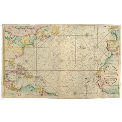
Nieuwe Wassende Graade Zee Kaart over de Spaanse Zee Vant Kanaal tot 't Eyland Cuba In Westindia.
Rare two-sheet blue-back sea chart of the Atlantic and Eastern part of North America., published by Gerard Van Keulen. The map extends from the latitude of Newfoundland and the English Channel in the north to the Equator in the south.In North America, most of the Great Lakes are shown and a large lake (Apalache Lac) in South Carolina. Florida is presented in a triangular shape.Florida is shown in a triangular model, with large islands forming the tip and numerous soundings along the coast. The ...
€2.500
Maker : VAN KEULEN, G.
Place : Amsterdam
Date : ca. 1728-1751
![[Lot of 8 maps and prints] Norvegiae Maritimae ab Elf-burgo ad Dronten / Pascaert van Noorwegen streckende van Elf-burg tot Dronten.](/uploads/cache/84130-500x500.jpg)
[Lot of 8 maps and prints] Norvegiae Maritimae ab Elf-burgo ad Dronten / Pascaert van Noorwegen streckende van Elf-burg tot Dronten.
Norvegiae Maritimae ab Elf-burgo ad Dronten / Pascaert van Noorwegen streckende van Elf-burg tot Dronten.Frederick de Wit's fine sea chart of southern Norway. An attractive sea chart of southern Norway and Sweden, richly embellished with a stunning large decorative title cartouche, showing the drying of cod. A lot of 8 maps including:-Carte du Detroit de Waeigats ou de Nassau 1758 -Partie de la Mer Glaciale 1758 -RVGIA VSEDO MIAE ET IVLINAE -Carte du Spits-Berg 1758 -Carte Des Pais Habites par�...
€900
Maker : DE WIT, Frederick.
Place : Amsterdam
Date : 1675
Postage & Shipping
-
Item Location
Terms and conditions - Item Location
- Amsterdam, , Netherlands
- Ships To
- Worldwide
- Pick-ups
- Buyer can pick-up
This item is owned and offered by the seller Papyro - All items are available for immediate sale, offered subject to prior sale.
Invoices are created by the seller by using our shopping cart or be prepared by the seller the day following the order and are emailed to you.
Items offeres by different sellers are invoiced separately.
Shipping fees are extra. The buyer is responsible for all applicable taxes, including any VAT, customs clearance, import duties, or equivalent costs arriving at the customer's home border. Payment is due on receipt of the invoice. The item(s) are shipped as soon as possible after receipt of your payment.
Before buying please read the complete Terms Conditions of Sale.
- Payment Methods
- Visa, Mastercard, Bank Transfer, PayPal
- Returns Accepted
- No
Post Message
Feel free to ask the seller a question. Please note that the seller could be located in an area with a different time zone. Our seller will do their best to respond within 24 hours.Post your message below.
Sign in to ask the seller a question.
![[Lot of 6] Carte de la Baye d'Hocsieu. Fukin. (3 Maps + 3 Gravure of China)](/uploads/cache/20019-500x500.jpg)
![[Set of 2 maps of Caspian Sea.] Carte marine de la Mer Caspiene. Levee suivant les ordres de S.M. Czariene, P](/uploads/cache/86020-(1)-500x500.jpg)