
ID: 180
Open
Listing ID: #180 has been added to your wishlist.
![[Lot of 8 maps and prints] Norvegiae Maritimae ab Elf-burgo ad Dronten / Pascaert van Noorwegen streckende van Elf-burg tot Dronten.](/uploads/84130.jpg)
[Lot of 8 maps and prints] Norvegiae Maritimae ab Elf-burgo ad Dronten / Pascaert van Noorwegen streckende van Elf-burg tot Dronten.
BuyNow for €900
- Maker :
- DE WIT, Frederick.
- Place :
- Amsterdam
- Date :
- 1675
- Color :
- Uncolored
- Height mm.:
- 490
- Width mm.:
- 560
- Condition :
- Except for a small restored worm-hole in very good condition, strong impression, thick clear paper, wide margins
- Bibliography :
- -
- Seller's ref. :
- 84130
This item is offered by Papyro
See other Items from this seller- Postage
-
Standard Shipping
€25 to Netherlands
- Select Country
- Zip/Post Code
- Quantity
€900
Description
Norvegiae Maritimae ab Elf-burgo ad Dronten / Pascaert van Noorwegen streckende van Elf-burg tot Dronten.Frederick de Wit's fine sea chart of southern Norway.
An attractive sea chart of southern Norway and Sweden, richly embellished with a stunning large decorative title cartouche, showing the drying of cod.
A lot of 8 maps including:
-Carte du Detroit de Waeigats ou de Nassau 1758
-Partie de la Mer Glaciale 1758
-RVGIA VSEDO MIAE ET IVLINAE
-Carte du Spits-Berg 1758
-Carte Des Pais Habites par Les Samojedes et Ostiacs Carte des Environs de Tornea De l'Europe figure Lii, Mer Baltique
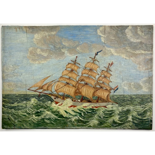
Painting made by a sailor, signed W. Welman.
Painting made by a sailor, signed W.Welman.
€250
Maker : WELMAN, W.
Place : Unknown
Date : c.1960
![[Lot of 3 maps] Carte de la Souveraineté de NEUCHATEL et VALLANGIN. Plus Mercator's and Blaeu's maps of the Wiflispurgergou]](/uploads/cache/85967-500x500.jpg)
[Lot of 3 maps] Carte de la Souveraineté de NEUCHATEL et VALLANGIN. Plus Mercator's and Blaeu's maps of the Wiflispurgergou]
Map of the lake of Neuchatel by Covens & Mortier. After the death of the widow of Pieter Mortier in 1719, the firm continued till 1778 as Covens & Mortier. They published numerous atlases and pocket atlases, using maps after de l' Isle and Map of the lake of Neuchatel.Plus Mercator's and Blaeu's maps of the Wiflispurgergou. [Lot of 3 maps]- Carte de la Souveraineté de NEUCHATEL et VALLANGIN- das WIFLISPUR-Gergow- Das WIFLISPUR-Gergow Blaeu 1610
€350
Maker : COVENS, J. / MORTIER, C.
Place : Amsterdam
Date : c. 1745

Le Kaire (Cairo). Vue de la place Ezbekyeh, côté du sud
A very fine view of Cairo.
€500
Maker : DUTERTRE / BEAUGEAN.
Place : Paris
Date : ca 1780
![[Lot of 2 prints of Globes] La Sphere Terrestre / La Sphere Celeste.](/uploads/cache/84233-500x500.jpg)
[Lot of 2 prints of Globes] La Sphere Terrestre / La Sphere Celeste.
La Sphere Terrestre / La Sphere CelesteA set of two very fine prints of a Terrestrial Sphere and a celestial Sphere. With an description on both sides. All within an elaborate and very decorative border. Claude Buy de Mornas (d. 1783), géographe du roi (1764). Atlas Méthodique et Elémentaire de Géographie et d' Histoire, 1761, Atlas Historique et Géographique, 1762.[Lot of 2 prints]
€450
Maker : DE MORNAS, C.
Place : Paris, L.C. Desnos
Date : 1761
Postage & Shipping
-
Item Location
Terms and conditions - Item Location
- Amsterdam, , Netherlands
- Ships To
- Worldwide
- Pick-ups
- Buyer can pick-up
This item is owned and offered by the seller Papyro - All items are available for immediate sale, offered subject to prior sale.
Invoices are created by the seller by using our shopping cart or be prepared by the seller the day following the order and are emailed to you.
Items offeres by different sellers are invoiced separately.
Shipping fees are extra. The buyer is responsible for all applicable taxes, including any VAT, customs clearance, import duties, or equivalent costs arriving at the customer's home border. Payment is due on receipt of the invoice. The item(s) are shipped as soon as possible after receipt of your payment.
Before buying please read the complete Terms Conditions of Sale.
- Payment Methods
- Visa, Mastercard, Bank Transfer, PayPal
- Returns Accepted
- No
Post Message
Feel free to ask the seller a question. Please note that the seller could be located in an area with a different time zone. Our seller will do their best to respond within 24 hours.Post your message below.
Sign in to ask the seller a question.
![[Lot of 8 maps and prints] Norvegiae Maritimae ab Elf-burgo ad Dronten / Pascaert van Noorwegen streckende van Elf-burg tot Dronten.](/uploads/cache/84130-500x500.jpg)