
ID: 173
Closed
Listing ID: #173 has been added to your wishlist.
![[Lot of 2 maps] Important plan of Port Bucarelli 1384 / Chart of the entrance of "Bassin de L'Quest", La Perouse. 1709](/uploads/20473.jpg)
[Lot of 2 maps] Important plan of Port Bucarelli 1384 / Chart of the entrance of "Bassin de L'Quest", La Perouse. 1709
BuyNow for €350
- Maker :
- La Pérouse, J.B.G. Comte de.
- Place :
- Paris
- Date :
- 1797
- Color :
- Colored
- Height mm.:
- 500
- Width mm.:
- 690
- Condition :
- In good condition.
- Bibliography :
- -
- Seller's ref. :
- 20473
This item is offered by Papyro
See other Items from this seller- Postage
-
Standard Shipping
€25 to Netherlands
- Select Country
- Zip/Post Code
- Quantity
€350
Description
Chart of the entrance of "Bassin de L'Quest", La Perouse. 1709 / With antique print of Alaska] Pirogue du port des Francais. / Pirogue, trouvee au port des Francais. 5958 / [Antique map of Alaska] Plan der Haven van Namganoodha in het eiland van Oonolaska. 2665 / Antique detail chart of the Nootka Channel] Schets van het Kanaal van Nootka. 3860. Plus 6 prints of natives of Alaska and their utensils. A plan of Port Bucarelli, Jean François Galoup, Comte de la Pérouse (1741-88), outstanding French explorer and hydrographer. ' Voyage autour du Monde. Atlas', 1797.Chart of the entrance of "Bassin de L'Quest", visited on July 2nd 1786 by La Perouse.
On many 18th century maps we find a depiction of Mer de L'Quest or Sea of the West a great sea, easily the size of the Mediterranean, to flow from the then-known Strait of Juan de Fuca and an opening to the ocean from this great sea at roughly in North California or Oregon and Quivira somewhere in Idaho.
A lot of 2 Maps
- Port des Français - Port de Bucarelli
![[Lot of 8 maps and prints] Norvegiae Maritimae ab Elf-burgo ad Dronten / Pascaert van Noorwegen streckende van Elf-burg tot Dronten.](/uploads/cache/84130-500x500.jpg)
[Lot of 8 maps and prints] Norvegiae Maritimae ab Elf-burgo ad Dronten / Pascaert van Noorwegen streckende van Elf-burg tot Dronten.
Norvegiae Maritimae ab Elf-burgo ad Dronten / Pascaert van Noorwegen streckende van Elf-burg tot Dronten.Frederick de Wit's fine sea chart of southern Norway. An attractive sea chart of southern Norway and Sweden, richly embellished with a stunning large decorative title cartouche, showing the drying of cod. A lot of 8 maps including:-Carte du Detroit de Waeigats ou de Nassau 1758 -Partie de la Mer Glaciale 1758 -RVGIA VSEDO MIAE ET IVLINAE -Carte du Spits-Berg 1758 -Carte Des Pais Habites par�...
€900
Maker : DE WIT, Frederick.
Place : Amsterdam
Date : 1675
![[Lot of 7 Flower prints] Talauma mutabilis. flower Talauma mutabilis from 'FLORA MALESIANA' Arckenhausen del. / Hutz Lith.](/uploads/cache/85382-500x500.jpg)
[Lot of 7 Flower prints] Talauma mutabilis. flower Talauma mutabilis from 'FLORA MALESIANA' Arckenhausen del. / Hutz Lith.
The flower Talauma mutabilis from 'FLORA MALESIANA'. Talauma mutabilis by Karl Ludwig von Blume (9 June 1796, Braunschweig – 3 February 1862, Leiden) was a German-Dutch botanist. (3454)Lot of 7 flower prints.- Talauma mutabilis - Sobralia Macrantha- Détails de la liane femelle du Chili- Liane femelle du Chili- Détails de la lianne màle du Chili- Dianthus sinensis heddewigii- Dianthus sinensis laciniatus
€300
Maker : BLUME, Carl Ludwig. von
Place : Germany
Date : 1829
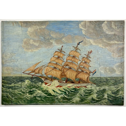
Painting made by a sailor, signed W. Welman.
Painting made by a sailor, signed W.Welman.
€250
Maker : WELMAN, W.
Place : Unknown
Date : c.1960

Nieuwe Paskaert van de Kust van HOLLANDT - Tussen Texel en de Maes.
Nieuwe Paskaert van de Kust van Hollandt Tussen Texel en de Maes. A very attractive sea chart off the coast of Holland by Johannes van Keulen with a pair of decorative cartouches, ships sailing off the coast, rhumb lines, compass rose etc. Van Keulen was the founder of the successful van Keulen firm that published charts, pilot guides and sea-atlases for over 2 centuries. In 1680, he published his immensely popular 'Zee Atlas ofte Water Werelt'.
€500
Maker : van Keulen, J.
Place : Amsterdam
Date : ca 1685
Postage & Shipping
-
Item Location
Terms and conditions - Item Location
- Amsterdam, , Netherlands
- Ships To
- Worldwide
- Pick-ups
- Buyer can pick-up
This item is owned and offered by the seller Papyro - All items are available for immediate sale, offered subject to prior sale.
Invoices are created by the seller by using our shopping cart or be prepared by the seller the day following the order and are emailed to you.
Items offeres by different sellers are invoiced separately.
Shipping fees are extra. The buyer is responsible for all applicable taxes, including any VAT, customs clearance, import duties, or equivalent costs arriving at the customer's home border. Payment is due on receipt of the invoice. The item(s) are shipped as soon as possible after receipt of your payment.
Before buying please read the complete Terms Conditions of Sale.
- Payment Methods
- Visa, Mastercard, Bank Transfer, PayPal
- Returns Accepted
- No
Post Message
Feel free to ask the seller a question. Please note that the seller could be located in an area with a different time zone. Our seller will do their best to respond within 24 hours.Post your message below.
Sign in to ask the seller a question.
![[Lot of 2 maps] Important plan of Port Bucarelli 1384 / Chart of the entrance of "Bassin de L'Quest", La Perouse. 1709](/assets/images/image-loading.svg)