
ID: 191
Open
Listing ID: #191 has been added to your wishlist.
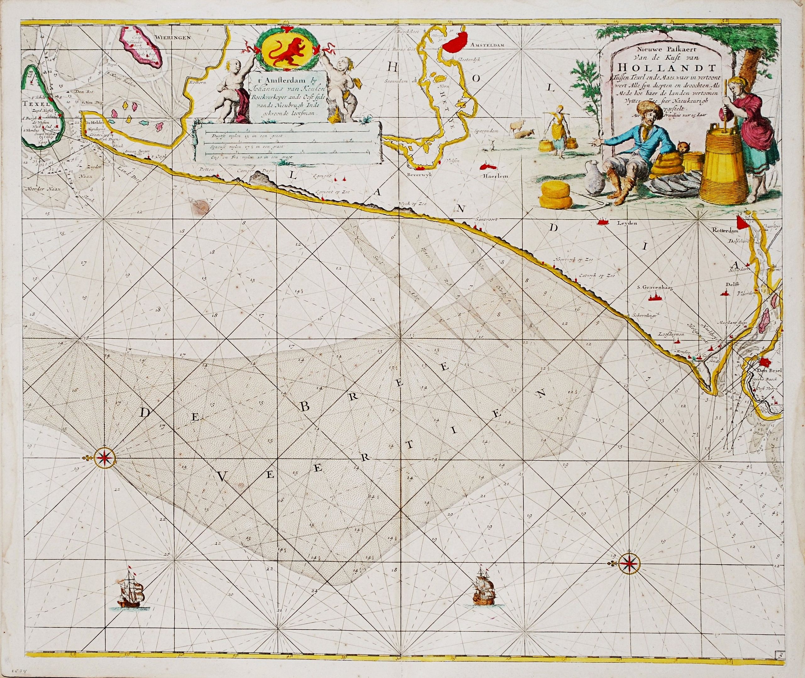
Nieuwe Paskaert van de Kust van HOLLANDT - Tussen Texel en de Maes.
BuyNow for €500
- Maker :
- van Keulen, J.
- Place :
- Amsterdam
- Date :
- ca 1685
- Color :
- Colored
- Height mm.:
- 510
- Width mm.:
- 585
- Condition :
- In very good condition.
- Bibliography :
- -
- Seller's ref. :
- 85996
This item is offered by Papyro
See other Items from this seller- Postage
-
Standard Shipping
€25 to Netherlands
- Select Country
- Zip/Post Code
- Quantity
€500
Description
Nieuwe Paskaert van de Kust van Hollandt Tussen Texel en de Maes.A very attractive sea chart off the coast of Holland by Johannes van Keulen with a pair of decorative cartouches, ships sailing off the coast, rhumb lines, compass rose etc.
Van Keulen was the founder of the successful van Keulen firm that published charts, pilot guides and sea-atlases for over 2 centuries. In 1680, he published his immensely popular 'Zee Atlas ofte Water Werelt'.

(Sea-chart of Catalunia, Languedoc, Provence, Cote d'Azur, Riviera, Corsica with Marseille, Cannes, Nice, Monaco.)
This very rare chart is important as the first printed sea chart of France's Mediterranean coast, also depicting Catalunya's northern coast, the Italian Cote d'Azur till San Remo and Corsica's west coast.Willem Barentsz (1560-1597) was a famous pilot, discoverer and cartographer. Author of 'Nieuwe Beschrhryvinghe ende caertboeck van de Midlantsche Zee', the first printed pilot-guide of the Mediterranean. It is considered the supplement of Waghenaer's 'Spieghel der Zeevaerdt' for the Mediterranea...
€4.000
Maker : BARENTSZ, Willem.
Place : Amsterdam
Date : 1607

Le Kaire (Cairo). Vue de la place Ezbekyeh, côté du sud
A very fine view of Cairo.
€500
Maker : DUTERTRE / BEAUGEAN.
Place : Paris
Date : ca 1780
![[Lot of 6 Maps of Germany] PALATINATUS BAVARIAE.](/uploads/cache/19093-500x500.jpg)
[Lot of 6 Maps of Germany] PALATINATUS BAVARIAE.
[Lot of 6 Maps of Germany]- La Basse Partie Du Cercle Du Haut Rhein divisé en tous ses Estats et Souverainetés. 1696 - (875x580 mm)- Wirtenberg Ducatus (Hondius) 1638 - (494x415 mm)- Partie Orientale Du Palatinat et Eslectorat Du Rhein. Les Eveschés De Spire, De Wormes et Le Comté de Linange. 1692 - (565x430 mm)An attractive map of Bayern, embellished with a fine strapwork title-cartouche and a cartouche with scales.From the Latin, 1613 edition.Gerard Mercator (1512-94). His ' Atlas sive...
€700
Maker : MERCATOR, G. / HONDIUS, J.
Place : Amsterdam
Date : 1619
Hydrograhica descriptio
This very rare chart is important as the first printed sea chart of the Mediterranean coast of Spain, Gibraltar, also depicting the northern coast of Marocco.Willem Barentsz (1560-1597) was a famous pilot, discoverer and cartographer. Author of 'Nieuwe Beschrhryvinghe ende caertboeck van de Midlantsche Zee', the first printed pilot-guide of the Mediterranean. It is considered the supplement of Waghenaer's 'Spieghel der Zeevaerdt' for the Mediterranean waters.
€4.000
Maker : BARENDTSZ, W.
Place : Amsterdam, W. Blaeu
Date : 1612
Postage & Shipping
-
Item Location
Terms and conditions - Item Location
- Amsterdam, , Netherlands
- Ships To
- Worldwide
- Pick-ups
- Buyer can pick-up
This item is owned and offered by the seller Papyro - All items are available for immediate sale, offered subject to prior sale.
Invoices are created by the seller by using our shopping cart or be prepared by the seller the day following the order and are emailed to you.
Items offeres by different sellers are invoiced separately.
Shipping fees are extra. The buyer is responsible for all applicable taxes, including any VAT, customs clearance, import duties, or equivalent costs arriving at the customer's home border. Payment is due on receipt of the invoice. The item(s) are shipped as soon as possible after receipt of your payment.
Before buying please read the complete Terms Conditions of Sale.
- Payment Methods
- Visa, Mastercard, Bank Transfer, PayPal
- Returns Accepted
- No
Post Message
Feel free to ask the seller a question. Please note that the seller could be located in an area with a different time zone. Our seller will do their best to respond within 24 hours.Post your message below.
Sign in to ask the seller a question.
