
ID: 131
Open

Europa recens descripta à Guilielmo Blaeuw.
BuyNow for €3.250
- Maker :
- BLAEU, W.
- Place :
- Amsterdam
- Date :
- 1644
- Color :
- Colored
- Height mm.:
- 410
- Width mm.:
- 552
- Condition :
- A dark impression. Printed on heavy paper. French text on verso.
- Bibliography :
- -
- Seller's ref. :
- 48713
This item is offered by Librairie_Loeb-Larocque
See other Items from this seller- Postage
-
Standard Shipping
€0 to France
- Select Country
- Zip/Post Code
- Quantity
€3.250
Description
On either side columns depicting the manner of dress in the major countries of Europe, surmounted by nine city views and plans.For European mapmakers their own continent contained few mysteries or secrets by the seventeenth century. However, the mythical island of Frisland still appears between Iceland and Greenland. The map is decorated with ships and a sea monster on the sea, bears on northern Russia, and lions on North Africa.
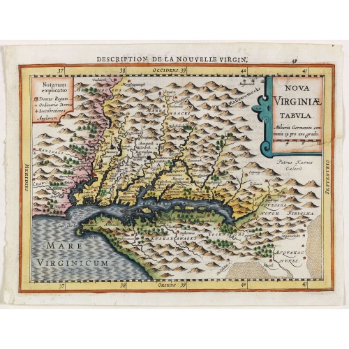
Virginiae item et Floridae . . .
Map of Virginia from the rare Cloppenburg edition slightly larger format and more scarce edition of the Mercator/Hondius "Atlas Minor". Engraved by Pieter Van Den Keere.The Cloppenburg edition "Atlas Sive Cosmographicae Meditationes De Fabrica Mundi Et Fabricati Figura", was continued for a couple of years but seems to have been suppressed after 1636 ... (Koeman Atlantes Neerlandici).Based on the 1595 Abraham Ortelius map, but with added decoration.
€750
Maker : MERCATOR, G. / CLOPPENBURGH, J.E.
Place : Amsterdam
Date : 1630
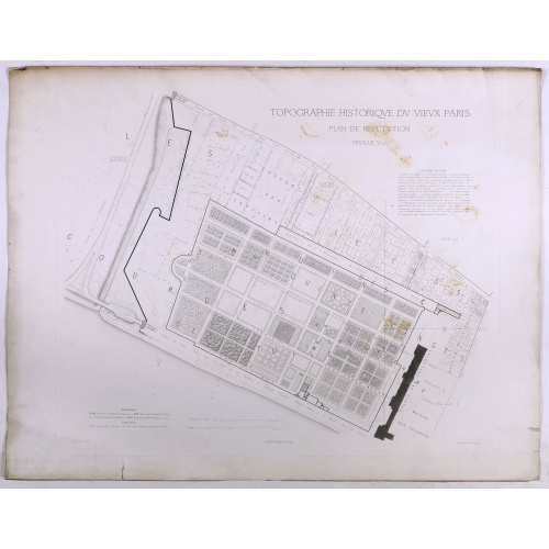
Topographie historique du vieux Paris / Plan de restitution Feuille V bis.
Copper engraved plan centered on gardens of the Louvre by Jean-Joseph Sulpis (1826–1911) after a model by Adolphe Berty. Plate 5bis from "Topographie historique du vieux Paris". The publication was started by Adolphe Berty and continued by H. Legrand and L.-M. Tisserand, Th. Vacquer and Camille Platon.
€50
Maker : BERTY, A.
Place : Paris
Date : 1866-1897

Particularitez Curieuses de l'Ile de St. Christophle et de la Province de Bemarin . . .
Six meticulously detailed and engraved scenes of the island of St. Kitts, also known as Saint Christopher, and the province of Bemarin, indigenous plants, animals, reptiles, fish, crustaceans and insects.On a single sheet from Volume Six of Chatelain's "Atlas Historique".From left to right, top, the illustrations depict the French General's palace on St. Kitts, Indians visiting the French, and a landscape in Bemarin Province. Zacharie Chatelain (d.1723) was the father of Henri Abraham (1684-1743...
€95
Maker : CHATELAIN, H.
Place : Amsterdam
Date : 1720
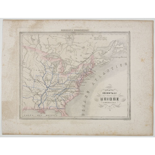
Stati Orientali della Unione Americana.
Uncommon map of Northeastern America prepared by Francesco Costantino Marmocchi. Above the map "Geografia Commerciale". From "Il Globo Atlante di carte Geografiche compilate da F.C. Marmocchi per servire di corredo al suu corso di geografia commerciale", with the maps engraved by engraved by Gius. Cattaneo, Campo Antico, C. Poggiali, G. Bonatti, and Ces. Magrini.Marmocchi (Poggibonsi, 1805-Geneva, 1858) was known as a geographer and cartographer. He emigrated to Rome, and later to Corsica, later...
€50
Maker : MARMOCCHI, F.C.
Place : Genova, Paolo Rivara fu Giacomo
Date : 1858
Postage & Shipping
-
Item Location
Terms and conditions - Item Location
- 75013, Alsace, France
- Ships To
- United States, United Kingdom, Albania, Argentina, Armenia, Australia, Austria, Bahamas, Belgium, Bermuda, Bosnia and Herzegowina, Brazil, Bulgaria, Canada, Chile, China, Costa Rica, Denmark, Dominica, Egypt, El Salvador, Finland, France, Germany, Greece, Guatemala, Hong Kong, Hungary, Iceland, India, Italy, Japan, Korea (South), Kuwait, Liechtenstein, Lithuania, Luxembourg, Madagascar, Mexico, Monaco, Morocco, Netherlands, Netherlands Antilles, New Zealand, Norway, Paraguay, Peru, Philippines, Poland, Portugal, Qatar, Reunion, Romania, San Marino, Saudi Arabia, Seychelles, Singapore, Slovenia, South Africa, Spain, Sri Lanka, Suriname, Sweden, Switzerland, Taiwan, Thailand, Tunisia, Turkey, United Arab Emirates, Uruguay, Vietnam
- Pick-ups
- Buyer can pick-up
This item is owned and offered by the seller Librairie_Loeb-Larocque - All items are available for immediate sale, offered subject to prior sale.
Invoices are created by the seller by using our shopping cart or be prepared by the seller the day following the order and are emailed to you.
Items offeres by different sellers are invoiced separately.
Shipping fees are extra. The buyer is responsible for all applicable taxes, including any VAT, customs clearance, import duties, or equivalent costs arriving at the customer's home border. Payment is due on receipt of the invoice. The item(s) are shipped as soon as possible after receipt of your payment.
Before buying please read the complete Terms Conditions of Sale.
- Payment Methods
- Visa, Mastercard, Bank Transfer, American Express, iDEAL, PayPal, Google Pay
- Returns Accepted
- No
Post Message
Feel free to ask the seller a question. Please note that the seller could be located in an area with a different time zone. Our seller will do their best to respond within 24 hours.Post your message below.
Sign in to ask the seller a question.
