
ID: 124
Open
![Boertige reis door Europa. . . [with] Europa volgens de nieuwste verdeeling. . .](/uploads/32642.jpg)
![Boertige reis door Europa. . . [with] Europa volgens de nieuwste verdeeling. . .](/uploads/32642X.jpg)
Boertige reis door Europa. . . [with] Europa volgens de nieuwste verdeeling. . .
BuyNow for €1.900
- Maker :
- BOHN, F.
- Place :
- Haarlem
- Date :
- 1794
- Color :
- In original color
- Height mm.:
- 235
- Width mm.:
- 169
- Condition :
- In-8. Seven parts in 3 volumes. Contemporary half calf, gilted spine with red leather spine labels with gilt lettering, marbled covers boards. Spine used. Inside very clean. With
- Bibliography :
- Lewes - Mercator's World Vol. 4, No. 1 - The Female Landscape
- Seller's ref. :
- 32642
This item is offered by Librairie_Loeb-Larocque
See other Items from this seller- Postage
-
Standard Shipping
€0 to Netherlands
- Select Country
- Zip/Post Code
- Quantity
€1.900
Description
Rare illustrated publication including a rare map of Europe as a regal queen with the title "Geheimzinnige toebereidselen tot eene boertige reis door Europa. [...] voorgeleezen in [...] de maatschappij der verdiensten, onder de spreuk: Felix Meritis. / By A. Fokke Simonsz".
The book contains a map of Europe (168x2369mm.) engraved by H.Klockhoff and a cartographical curiosity, "Europa volgens de nieuwste verdeeling...", Europe as a regal queen but with an interesting twist and political commentary.
This anti-Napoleonic image demotes Europa from a virgin queen to a homely middle-aged housewife.
The figure is superimposed over a map with a fair amount of detail.
The Iberian peninsula as a head, Italy as her left arm, stirring with her right arm (Corsica and Sardinia) in a pot (Sicily). Her scarf forms Britain, and the rest of the continent is encompassed in her flowing dress.
Printed by Francois Bohn in Haarlem, who was active from 1786 till 1819.
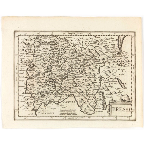
Bresse.
Early map of Eastern France and part of Switzerland. Geneva in upper right corner. With Latin text on verso. Engraved by Petrus Kaerius. Shortly after the publication of big folio-atlases the need was apparently felt for a smaller sized atlas, one that would be handier and, above all, cheaper. Joh. Cloppenburgh published in 1630 a atlas based on Mercator's pocket map, but in a slightly larger size. He published a Latin text edition in 1632.
€50
Maker : CLOPPENBURGH, J.E.
Place : Amsterdam
Date : 1632
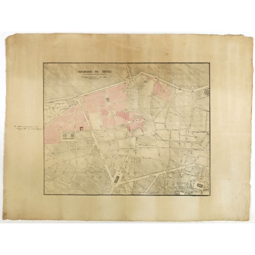
Quartier de Tivoli Nouveaux pereements de Rues.
Plan of the center of Paris showing Tivoli district with Madalene and Clichy. Lithography and pen and ink. Drawn in are the planned workshop of Serrurerie Théophile Mignon, 30 rue de la Bienfaisance.
€75
Maker : ANNONYMOUS
Place : Paris
Date : ca.1835
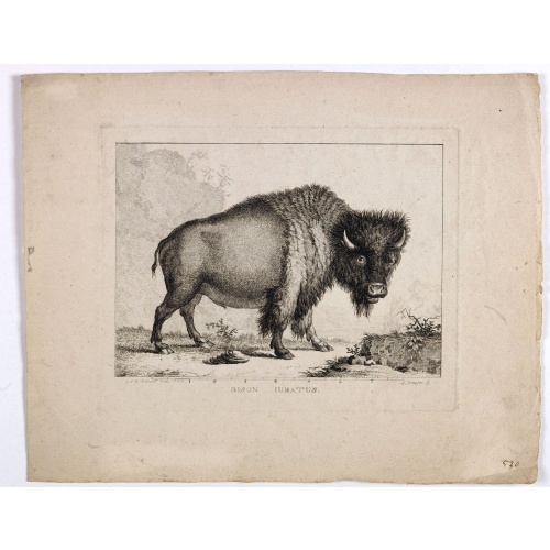
Bison Iubatus.
Etching of a bison by Leendert Brasser (1727 - 1793) after a painting of the Dutch artist Gerrit van den Heuvel.An early portrait of a bison, etched by Leendert Brasser (1727-93) after Gerrit van den Heuvel.Gerrit van den Heuvel portraited this bison in 1766 in the menagerie of Arnout Vosmaer (1720 - 1799). Vosmaer was a Dutch naturalist and collection curator. In 1756 Vosmaer became the director of a natural history collection started by Princess Anna, the wife of William IV, Prince of Orange a...
€750
Maker : BRASSIER, L
Place : Rotterdam
Date : 1766-1793
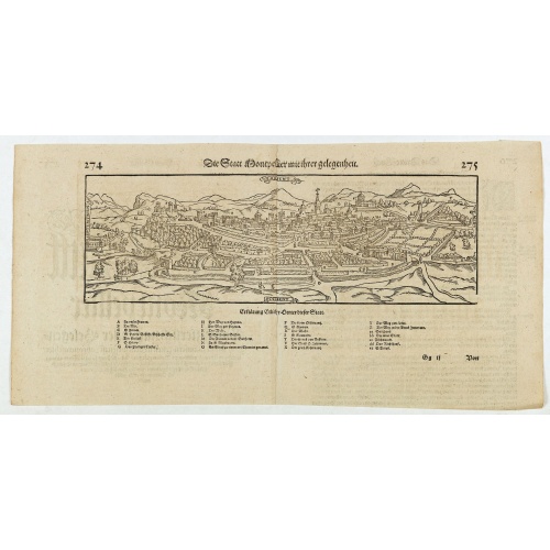
Die statt Montpellier . . .
Panoramic view of Montpellier by Sebastian Münster. Below the engraving a letterpress key. From the German edition of Sebastian Munster's Cosmography, "Cosmographey oder beschreibung aller Länder".
€75
Maker : MÜNSTER, S
Place : Basel, Heinrich Petri
Date : 1574
Postage & Shipping
-
Item Location
Terms and conditions - Item Location
- 75013, Ile-de-France, France
- Ships To
- United States, United Kingdom, Albania, Argentina, Armenia, Australia, Austria, Bahamas, Belgium, Bermuda, Bosnia and Herzegowina, Brazil, Bulgaria, Canada, Chile, China, Costa Rica, Denmark, Dominica, Egypt, El Salvador, Finland, France, Germany, Greece, Guatemala, Hong Kong, Hungary, Iceland, India, Italy, Japan, Korea (South), Kuwait, Liechtenstein, Lithuania, Luxembourg, Madagascar, Mexico, Monaco, Morocco, Netherlands, Netherlands Antilles, New Zealand, Norway, Paraguay, Peru, Philippines, Poland, Portugal, Qatar, Reunion, Romania, San Marino, Saudi Arabia, Seychelles, Singapore, Slovenia, South Africa, Spain, Sri Lanka, Suriname, Sweden, Switzerland, Taiwan, Thailand, Tunisia, Turkey, United Arab Emirates, Uruguay, Vietnam
- Pick-ups
- Buyer can pick-up
This item is owned and offered by the seller Librairie_Loeb-Larocque - All items are available for immediate sale, offered subject to prior sale.
Invoices are created by the seller by using our shopping cart or be prepared by the seller the day following the order and are emailed to you.
Items offeres by different sellers are invoiced separately.
Shipping fees are extra. The buyer is responsible for all applicable taxes, including any VAT, customs clearance, import duties, or equivalent costs arriving at the customer's home border. Payment is due on receipt of the invoice. The item(s) are shipped as soon as possible after receipt of your payment.
Before buying please read the complete Terms Conditions of Sale.
- Payment Methods
- Visa, Mastercard, Bank Transfer, American Express, iDEAL, PayPal, Google Pay
- Returns Accepted
- No
Post Message
Feel free to ask the seller a question. Please note that the seller could be located in an area with a different time zone. Our seller will do their best to respond within 24 hours.Post your message below.
Sign in to ask the seller a question.
![Boertige reis door Europa. . . [with] Europa volgens de nieuwste verdeeling. . .](/uploads/cache/32642-500x500.jpg)