ID: 234
Open
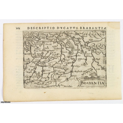
Brabantia.
BuyNow for $100
- Maker :
- LANGENES, B. / BERTIUS, P.
- Place :
- Amsterdam, 1606
- Date :
- 1606
- Color :
- Uncoloured
- Height mm.:
- 83
- Width mm.:
- 123
- Condition :
- In very good condition, lightly age toned, slight water stain, with wide margins, dark impression. Latin text to verso.
- Bibliography :
- -
- Seller's ref. :
- 43214
This item is offered by Paulus_Swaen_Old_Maps
See other Items from this seller- Postage
-
Europe
$34 to France
- Select Country
- Zip/Post Code
- Quantity
$100
Description
A lovely miniature map of the Duchy of Brabant, published by Petrus Bertius, in Amsterdam at the beginning of the seventeenth century.There is a nice, small strap-work title, a little stippled sea, and the map depicts local topography and towns including Mechelen, Breda, Cleve, Maestricht, Cologne, Brussels and Namur. This example is from the Tabularum Geographicarum Contractarum.
Bertius (1565-1629) was a Flemish cartographer, theologian, historian and geographer. Although he published much in the fields of history, theology and mathematics, he is perhaps best known as a cartographer. His works were heavily influenced by the earlier works of Mercator, which date from the late sixteenth century. He was connected by marriage to Jacobus Hondius and Pieter van den Keere, both excellent cartographers, who would influence his later life. He was ‘Cosmographer’ to the court of King Louis XIII.
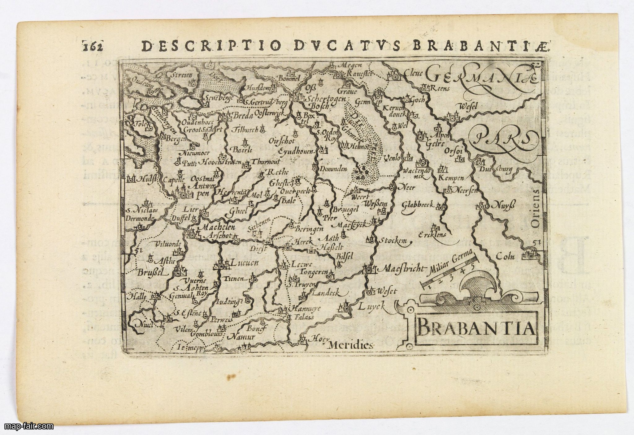
Tobago.
A delightfully detailed map of the West Indian island Tobago by John Thomson. The map displays excellent detail concerning roads, rivers, towns, bays, harbors, and other interesting topographical details.Thomson (1777-c1840) was a Scottish cartographer from Edinburgh, celebrated for his 1817 New General Atlas, published by himself in Edinburgh, John Cumming in Dublin, and Baldwin, Cradock, and Joy in London.
$50
Maker : THOMSON, J.
Place : Edenburgh
Date : 1821
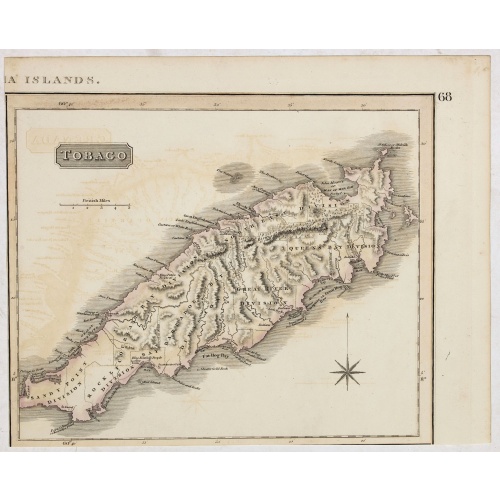
Residence of A.S. Doane Doanesburg Putnam Co. N.Y. - N. L. Thompsons's lake Mahopac - The Gregory House lake Mahopac Putnam Co N. Y. Lewis H. Gregory Proprietor.
Three heliographic prints on one sheet : "Residence of A.S. Doane Doanesburg Putnam Co. N.Y. (120x150mm.) / N. L. Thompsons's lake Mahopac (120 x 160mm.) / The Gregory House lake Mahopac Putnam Co N. Y. Lewis H. Gregory Proprietor. (210 x 320mm.)." After design by R.K.Sneden (120 x 160mm.).From Beer's famous county atlas "Atlas of New York and vicinity", "a documentary record of nineteenth century life and delightful specimens of American folk art. F. W. Beers, along with other members of his fa...
$90
Maker : DE BEERS, F.W.
Place : New York,1867
Date : 1867

Beschrijvinge vande de zee Cuften va Vlanderen en Picardien. . .
DUTCH TEXT EDITION. A detailed chart of the coast of Flanders and Normandy decorated by a large colorful baroque title cartouche, and the coat of arms of Flanders with a colorful scale cartouche decorated with a compass, a compass rose, several vessels and sea monsters. From an early Dutch text edition of this landmark contribution to the science of navigation. Waghenaer's own personal experiences as a pilot along European coasts were used to compile the Spiegel der Zeevaerdt, the first edition ...
$3.000
Maker : WAGHENAER, L. J.
Place : Leiden, Plantijn
Date : 1585
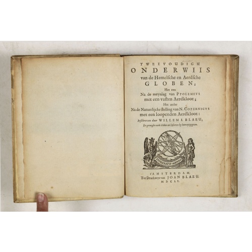
Tweevoudigh onderwiis van de Hemelsche en Aerdsche Globen; Het een Na de meyning van Ptolemeus met een vasten Aerdkloot...
Tweevoudigh onderwiis van de Hemelsche en Aerdsche Globen; Het een Na de meyning van Ptolemeus met een vasten Aerdkloot; Het ander Na de Natuerlijcke stelling van N. Copernicus met een loopenden Aerdkloot:Willem Blaeu's guide to the making of globes, first published in 1620, here reprinted by his son, Joan.The book consists of two parts; volume I : Astronomical principles of celestial and terrestrial globes based on the inadequate hypothesis of Ptolemy.Volume II : Astronomical principles of glob...
$2.250
Maker : BLAEU, W.
Place : Amsterdam
Date : 1655
Postage & Shipping
-
Item Location
Terms and conditions - Item Location
- Amsterdam, , Netherlands
- Ships To
- United States, United Kingdom, Albania, Argentina, Armenia, Australia, Azerbaijan, Bahamas, Belgium, Bermuda, Cambodia, Canada, Chile, China, Croatia, Cyprus, Czech Republic, Denmark, Estonia, Finland, France, Germany, Gibraltar, Greece, Greenland, Guatemala, Hong Kong, Iceland, India, Indonesia, Israel, Italy, Japan, Latvia, Lithuania, Luxembourg, Malta, Mexico, Monaco, Netherlands, Norway, Singapore, Spain, Sweden, Switzerland, Turkey
- Pick-ups
- No pick-ups
This item is owned and offered by the seller Paulus_Swaen_Old_Maps - All items are available for immediate sale, offered subject to prior sale.
Invoices are created by the seller by using our shopping cart or be prepared by the seller the day following the order and are emailed to you.
Items offeres by different sellers are invoiced separately.
Shipping fees are extra. The buyer is responsible for all applicable taxes, including any VAT, customs clearance, import duties, or equivalent costs arriving at the customer's home border. Payment is due on receipt of the invoice. The item(s) are shipped as soon as possible after receipt of your payment.
Before buying please read the complete Terms Conditions of Sale.
- Payment Methods
- Visa, Mastercard, Bank Transfer, iDEAL, PayPal
- Returns Accepted
- No
Post Message
Feel free to ask the seller a question. Please note that the seller could be located in an area with a different time zone. Our seller will do their best to respond within 24 hours.Post your message below.
Sign in to ask the seller a question.