
ID: 112
Open
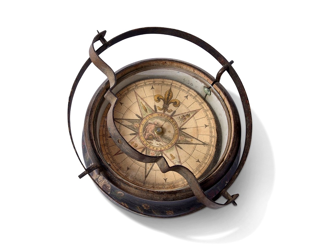
Inverted nautical Compass, called "mouchard" (~ "spy-glass")
BuyNow for $7.500
- Maker :
- VAN VASTENHOUD, A.
- Place :
- Amsterdam
- Date :
- ca. 1780
- Color :
- In original color
- Height mm.:
- 160
- Width mm.:
- 160
- Condition :
- Diameter 16cm. In original wooden case, in gimbals and oak surround.
- Bibliography :
- -
- Seller's ref. :
- 48678
This item is offered by Paulus_Swaen_Old_Maps
See other Items from this seller- Postage
-
Standard Shipping
$0 to Netherlands
- Select Country
- Zip/Post Code
- Quantity
$7.500
Description
Inverted maritime compass called "mouchard" (spy) in wood and brass, signed "A Van Vastenhoud In Amsterdam". This type of compass was found in the captain's cabin and hanging above the captain's bed. The captain was so able to see the direction when he was in his cabin.This example is mounted in a wooden box to keep it safe. The compass itself is mounted on brass gimbals to keep it steady on a moving ship. It has a single iron needle with a brass cap that rests on a spike projecting from the bottom of the bowl, which also contains some lead to weigh it down and keep it steady.
The compass card is made of paper and is marked both in degrees and with the points of the compass. North is indicated by a fleur-de-lys, while the other cardinal and half-cardinal points have images of figures of blowing heads, ships, and floral designs.
The center design has Neptune staring at sea with a ship in the background.
Some small blobs of sealing wax remain on the underside of the card (they were originally put there to keep it balanced).

Vertoog van het regt, Dat de Vereenigde Nederlandsche Oost-Indische maatschappye Heeft op de Vaart en Koophandel naar Oost-Indiën, Tegen de inwooners van de Spaanse, nu de Oostenrykse Nederlanden.
Dutch translation of the Latin edition, published in 1723. Westerveen was the secretary of the Dutch East India Company and writes on the right of the VOC to trade as well as on VOC maritime trade with the East Indies. Westerveen also addresses these matters with regard to the Dutch West India Company and deals with Dutch trade in the light of the interests of both Spain and Portugal in the Americas and in Asia.Also contains an interesting Extract uyt de Resolutien door den Gouverneur Generaal e...
$1.200
Maker : WESTERVEEN, A.
Place : Amsterdam
Date : 1724

Pas-Kaat vaneen gedeelte van de Aethiopische Zee behelsende de Kusten Zanguebar, Ajan en Abex, en een gedeelte van de Arabische Kust. . .
A finely engraved and detailed chart of the most eastern tip of Africa, including Somalia, Djibouti, Yemen, Mauritius, and many other islands in the Indian Ocean.Very rare: only included in 6th volume (so-called secret atlas) of Van Keulen's. Latitude scale, compass rose and system of rhumb lines, soundings, anchorage's, etc. Many Dutch names and a wealth of cities and information appear in the chart. The trading posts of the different nations are marked with flags. Number 47. in lower left corn...
$4.500
Maker : VAN KEULEN, J.
Place : Amsterdam
Date : 1753

A ship's hour glass.
Maritime hourglass with blown glass bulbs, orange sand, junction ring covered with cord, the circular ebony frame with six turned baluster columns.The invention of the hourglass is attributed to an 8th-century monk in Chartres, France, with the marine sandglass appearing as early as the 14th century. In earlier examples, the bulbs were connected with a material such as putty or hardened wax, bound in leather, linen or string. From about 1720, the two bulbs were welded together over a brass bead ...
$1.750
Maker : ANONYMOUS
Place : The Netherlands or Germany
Date : ca. 1750

A ship's hour glass.
Maritime hourglass with blown glass bulbs, orange sand, junction ring covered with cord, the circular ebony frame with six turned baluster columns. The invention of the hourglass is attributed to an 8th-century monk in Chartres, France, with the marine sandglass appearing as early as the 14th century. In earlier examples, the bulbs were connected with a material such as putty or hardened wax, bound in leather, linen or string. From about 1720, the two bulbs were welded together over a brass bead...
$2.000
Maker : ANONYMOUS
Place : Germany
Date : ca. 1750
Postage & Shipping
-
Item Location
Terms and conditions - Item Location
- Amsterdam, , Netherlands
- Ships To
- United States, United Kingdom, Albania, Argentina, Armenia, Australia, Azerbaijan, Bahamas, Belgium, Bermuda, Cambodia, Canada, Chile, China, Croatia, Cyprus, Czech Republic, Denmark, Estonia, Finland, France, Germany, Gibraltar, Greece, Greenland, Guatemala, Hong Kong, Iceland, India, Indonesia, Israel, Italy, Japan, Latvia, Lithuania, Luxembourg, Malta, Mexico, Monaco, Netherlands, Norway, Singapore, Spain, Sweden, Switzerland, Turkey
- Pick-ups
- No pick-ups
This item is owned and offered by the seller Paulus_Swaen_Old_Maps - All items are available for immediate sale, offered subject to prior sale.
Invoices are created by the seller by using our shopping cart or be prepared by the seller the day following the order and are emailed to you.
Items offeres by different sellers are invoiced separately.
Shipping fees are extra. The buyer is responsible for all applicable taxes, including any VAT, customs clearance, import duties, or equivalent costs arriving at the customer's home border. Payment is due on receipt of the invoice. The item(s) are shipped as soon as possible after receipt of your payment.
Before buying please read the complete Terms Conditions of Sale.
- Payment Methods
- Visa, Mastercard, Bank Transfer, iDEAL, PayPal
- Returns Accepted
- No
Post Message
Feel free to ask the seller a question. Please note that the seller could be located in an area with a different time zone. Our seller will do their best to respond within 24 hours.Post your message below.
Sign in to ask the seller a question.
