
ID: 112
Open
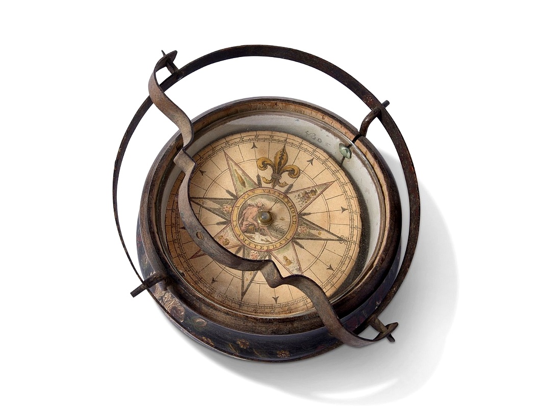
Inverted nautical Compass, called "mouchard" (~ "spy-glass")
BuyNow for $7.500
- Maker :
- VAN VASTENHOUD, A.
- Place :
- Amsterdam
- Date :
- ca. 1780
- Color :
- In original color
- Height mm.:
- 160
- Width mm.:
- 160
- Condition :
- Diameter 16cm. In original wooden case, in gimbals and oak surround.
- Bibliography :
- -
- Seller's ref. :
- 48678
This item is offered by Paulus_Swaen_Old_Maps
See other Items from this seller- Postage
-
Standard Shipping
$0 to Netherlands
- Select Country
- Zip/Post Code
- Quantity
$7.500
Description
Inverted maritime compass called "mouchard" (spy) in wood and brass, signed "A Van Vastenhoud In Amsterdam". This type of compass was found in the captain's cabin and hanging above the captain's bed. The captain was so able to see the direction when he was in his cabin.This example is mounted in a wooden box to keep it safe. The compass itself is mounted on brass gimbals to keep it steady on a moving ship. It has a single iron needle with a brass cap that rests on a spike projecting from the bottom of the bowl, which also contains some lead to weigh it down and keep it steady.
The compass card is made of paper and is marked both in degrees and with the points of the compass. North is indicated by a fleur-de-lys, while the other cardinal and half-cardinal points have images of figures of blowing heads, ships, and floral designs.
The center design has Neptune staring at sea with a ship in the background.
Some small blobs of sealing wax remain on the underside of the card (they were originally put there to keep it balanced).

A new mape of Ye XVII Provinces of Low Germanie.
Showing all 17 Provinces of the Netherlands before the split between Spain and the Protestant Provinces under the House of Orange.The map was first published. At the same time, the war of independence was still being fought against Philip II. With columns of figures on either side and surmounted by eight city prospects. A famous and most decorative item.A fourth state published by Thomas Basset and Richard Chiswell. The date has been removed and Speed's name has been added to the title cartouche...
$2.300
Maker : SPEED, J.
Place : London, 1676
Date : 1626

Beschrijvinge vande de zee Cuften va Vlanderen en Picardien. . .
DUTCH TEXT EDITION. A detailed chart of the coast of Flanders and Normandy decorated by a large colorful baroque title cartouche, and the coat of arms of Flanders with a colorful scale cartouche decorated with a compass, a compass rose, several vessels and sea monsters. From an early Dutch text edition of this landmark contribution to the science of navigation. Waghenaer's own personal experiences as a pilot along European coasts were used to compile the Spiegel der Zeevaerdt, the first edition ...
$3.000
Maker : WAGHENAER, L. J.
Place : Leiden, Plantijn
Date : 1585

Compass.
A sloop compass in the original wooden box with lit. The compass with floating rose (Cardan system). Slung in gimbals, the east point is decorated and graduated in half points and decorated N & E points.The cardan suspension system, also called a gimbal, is a pivotal support that allows the rotation of an object about a single axis. If simultaneously assembled three rings, one on another by orthogonal rotation axes, an object placed inside the third ring always remains horizontal, regardless of...
$650
Maker : ANONYMOUS
Place : Unknown
Date : c. 1890-1900

Rotterdam
A bird's-eye view of the town. With extensive shipping in the foreground. From "Topographia Germaniae Inferioris". Matthäus Merian, the leading German illustrator of the 17th century, was born in Basel in 1593. He learned the art of copperplate engraving in Zurich and subsequently worked and studied in Strasbourg, Nancy, Paris, and the Low Countries. In 1618 he went to Frankfurt, wherein 1618 he marries the eldest daughter of J.T. de Bry, publisher and engraver. After de Bry died in 1623, he ...
$1.750
Maker : MERIAN, C.
Place : Frankfurt
Date : 1659
Postage & Shipping
-
Item Location
Terms and conditions - Item Location
- Zwijndrecht, , Netherlands
- Ships To
- United States, United Kingdom, Albania, Argentina, Armenia, Australia, Azerbaijan, Bahamas, Belgium, Bermuda, Cambodia, Canada, Chile, China, Croatia, Cyprus, Czech Republic, Denmark, Estonia, Finland, France, Germany, Gibraltar, Greece, Greenland, Guatemala, Hong Kong, Iceland, India, Indonesia, Israel, Italy, Japan, Latvia, Lithuania, Luxembourg, Malta, Mexico, Monaco, Netherlands, Norway, Singapore, Spain, Sweden, Switzerland, Turkey
- Pick-ups
- No pick-ups
This item is owned and offered by the seller Paulus_Swaen_Old_Maps - All items are available for immediate sale, offered subject to prior sale.
Invoices are created by the seller by using our shopping cart or be prepared by the seller the day following the order and are emailed to you.
Items offeres by different sellers are invoiced separately.
Shipping fees are extra. The buyer is responsible for all applicable taxes, including any VAT, customs clearance, import duties, or equivalent costs arriving at the customer's home border. Payment is due on receipt of the invoice. The item(s) are shipped as soon as possible after receipt of your payment.
Before buying please read the complete Terms Conditions of Sale.
- Payment Methods
- Visa, Mastercard, Bank Transfer, iDEAL, PayPal
- Returns Accepted
- No
Post Message
Feel free to ask the seller a question. Please note that the seller could be located in an area with a different time zone. Our seller will do their best to respond within 24 hours.Post your message below.
Sign in to ask the seller a question.
