
ID: 103
Open
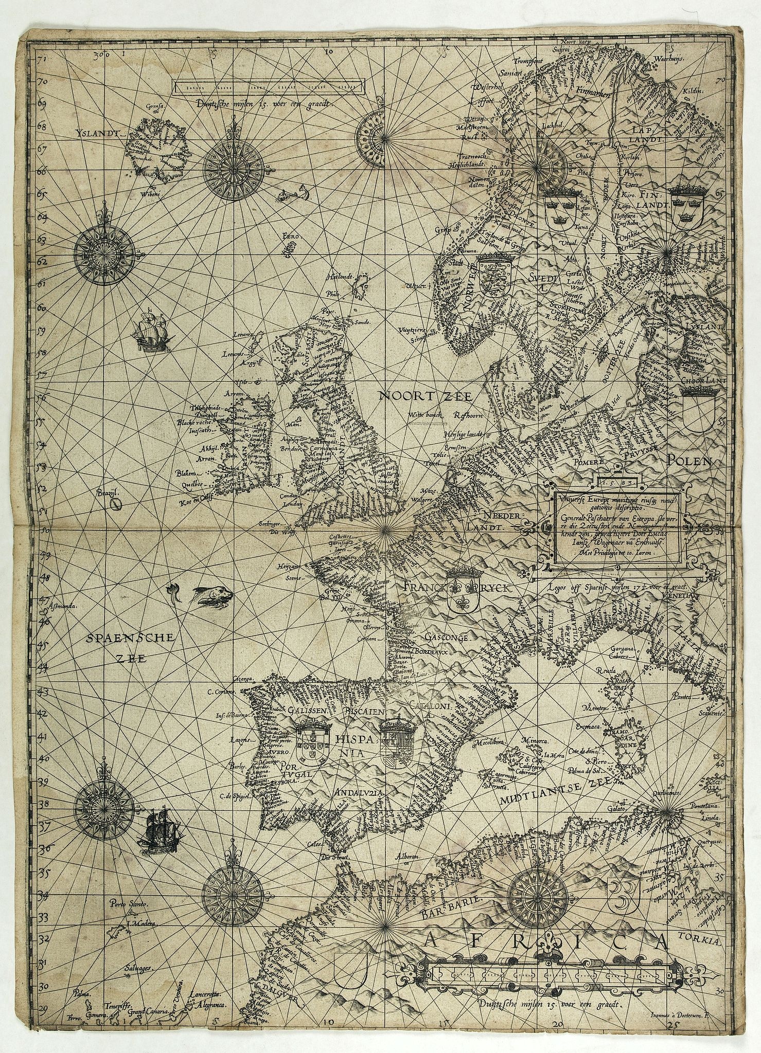
Universe Europae Maritime Eiusque Navigationis Descriptio. Generale Pascaerte van Europa . . .
BuyNow for $25.000
- Maker :
- WAGHENAER, L.J.
- Place :
- Leyden
- Date :
- 1584
- Color :
- Uncoloured
- Height mm.:
- 605
- Width mm.:
- 525
- Condition :
- Dutch text on verso. Some browning, foxing. A few worm holes filled in. The Europe chart is larger than the other charts in the atlas, as often the case the lower margin is trimmed affecting part of the grade scale. Dark impression.
- Bibliography :
- Koeman Wag 1 B.
- Seller's ref. :
- 42046
This item is offered by Paulus_Swaen_Old_Maps
See other Items from this seller- Postage
-
Standard Shipping
$0 to Netherlands
- Select Country
- Zip/Post Code
- Quantity
$25.000
Description
This general chart of north-western Europe and the surrounding coastal waters is from the rare pilot-guide De Spiegel der Zeevaerdt , printed by Christopher Plantin in Leyden.FIRST PLATE AND FIRST STATE, which appeared in the first 3 editions, before Latin names of some seas and inscriptions in the scale bars were added. (editions 4-12). EXTREMELY RARE.
The map's title is given in both Latin and Dutch, with the latter attributing it to Waghenaer and nothing a privilege of ten years. The date 1583 is engraved in a box capping the title cartouche. The chart is signed "Ioannes à Doetecum". It may have been that Waghenaer had already sold this portolan chart in 1579.
The place names are written inland continuously around the coast from north to south, in order to facilitate the navigator's readings accomplished by rotating the map.
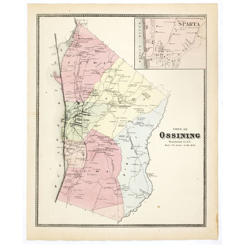
Town of Ossining. Westchester Co. NY.
Fine lithographed map of the town of Ossining. The map provides the names of specific homeowners, as well as information about the occupations and physical locations of the various tradesmen in each village from Beer's famous county atlas "Atlas of New York and vicinity, a documentary record of nineteenth-century life and delightful specimens of American folk art." F. W. Beers, along with other members of his family, were among the leading county atlas publishers in the period immediately follow...
$90
Maker : DE BEERS, F.W.
Place : New York
Date : 1867
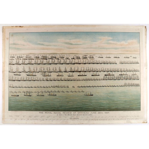
The Royal Naval review at Spithead, June 26th, 1897. In Honour of Her Majesty Queen Victoria's Diamond Jubilee.
A very decorative and large chromolithographed plate showing a line up of international vessels at Spithead, June 26th, 1897 In Honour of her Majesty Queen Victoria'a Diamond Jubilee. Below names of all International and British vessels giving presence on that day.
$750
Maker : JOGHNSON & LOGAN
Place : Portsea
Date : ca. 1897

Descriptio Transisalaniae.
An original early 17th century copper engraved miniature antique map of the eastern Dutch region of Overijssel by Petrus Bertius. The title is displayed in a simple strapwork cartouche with the further title in bold letters above the map. Zwolle the capital city is engraved, along with Lochem, Zutphen, Apeldoorn, Deventer, Hengelo and Enschede. From the Bertius atlas Tabularum geographicarum contractarum. Bertius (1565-1629) was a Flemish cartographer, theologian, historian and geographer. Altho...
$100
Maker : LANGENES, B. / BERTIUS, P.
Place : Amsterdam
Date : 1606
![[How natives of Paria cope with illness] / Vespucci reaches Lake Maracaibo]..](/uploads/cache/41095-(2)-500x500.jpg)
[How natives of Paria cope with illness] / Vespucci reaches Lake Maracaibo]..
Two engravings. [421b] When the natives of those parts, they were bathed in a cold stream, then chased round a blazing fire until they had dried out. Then they were put to bed and great care was taken to ensure their loins were dry. Vomiting was overcome by fasting for three or four days and paying careful attention to diet., which rarely included meat, except for human flesh, of which they were inordinately fond. In fact they would even fatten their enemy captives before eating them and seemed ...
$80
Maker : GOTTFRIED, J.L. / DE BRY.
Place : Frankfurt, M.Merian
Date : 1633
Postage & Shipping
-
Item Location
Terms and conditions - Item Location
- 75013, Ile-de-France, France
- Ships To
- United States, United Kingdom, Albania, Argentina, Armenia, Australia, Azerbaijan, Bahamas, Belgium, Bermuda, Cambodia, Canada, Chile, China, Croatia, Cyprus, Czech Republic, Denmark, Estonia, Finland, France, Germany, Gibraltar, Greece, Greenland, Guatemala, Hong Kong, Iceland, India, Indonesia, Israel, Italy, Japan, Latvia, Lithuania, Luxembourg, Malta, Mexico, Monaco, Netherlands, Norway, Singapore, Spain, Sweden, Switzerland, Turkey
- Pick-ups
- No pick-ups
This item is owned and offered by the seller Paulus_Swaen_Old_Maps - All items are available for immediate sale, offered subject to prior sale.
Invoices are created by the seller by using our shopping cart or be prepared by the seller the day following the order and are emailed to you.
Items offeres by different sellers are invoiced separately.
Shipping fees are extra. The buyer is responsible for all applicable taxes, including any VAT, customs clearance, import duties, or equivalent costs arriving at the customer's home border. Payment is due on receipt of the invoice. The item(s) are shipped as soon as possible after receipt of your payment.
Before buying please read the complete Terms Conditions of Sale.
- Payment Methods
- Bank Transfer
- Returns Accepted
- No
Post Message
Feel free to ask the seller a question. Please note that the seller could be located in an area with a different time zone. Our seller will do their best to respond within 24 hours.Post your message below.
Sign in to ask the seller a question.
