
ID: 146
Open
Listing ID: #146 has been added to your wishlist.
![[Ternate].](/uploads/37954.jpg)
[Ternate].
BuyNow for $150
- Maker :
- LODEWYCKSZ, Willem
- Place :
- Amsterdam, Cornille Nicolas
- Date :
- 1609
- Color :
- Uncoloured
- Height mm.:
- 138
- Width mm.:
- 215
- Condition :
- Paper limp, small tears to margins, and a diagonal paper crease, else in good condition Set in French text. Size of map 138 x 215mm.
- Bibliography :
- -
- Seller's ref. :
- 37954
This item is offered by Paulus_Swaen_Old_Maps
See other Items from this seller- Postage
-
Europe
$34 to France
- Select Country
- Zip/Post Code
- Quantity
$150
Description
Text engraving showing a bay on the Island of Ternate, an island in the Maluku Islands (Moluccas) of eastern Indonesia. Above the map a lettered key (A-E). Text engraving from "Premier livre de l'histoire de la navigation aux Indes Orientales, par les hollandois, et des choses a eux advenues . . . ", being the classic account of the first Dutch voyage to the East Indies under the command of Cornelis de Houtman. the expedition left in 1595, after Holland had achieved independence from Spain and could therefore freely explore its own interests in the East.
The ships sailed across the Atlantic to Brazil, and rounded the Cape of Good Hope on 7 February 1595. They arrived in Sumatra in May 1596 and proceeded to Java with the intention of reaching the Moluccas.
The ships were un-seaworthy, however, and troubles arose between captains and crew.
Finally reaching an accord, they sailed to Bali and returned to Texel in August 1597, with only eighty-nine of the crew left alive. Because of the increased price of pepper, the voyage was able to turn a profit, despite returning with a small cargo.

Beschrijvinge vande de zee Cuften va Vlanderen en Picardien. . .
DUTCH TEXT EDITION. A detailed chart of the coast of Flanders and Normandy decorated by a large colorful baroque title cartouche, and the coat of arms of Flanders with a colorful scale cartouche decorated with a compass, a compass rose, several vessels and sea monsters. From an early Dutch text edition of this landmark contribution to the science of navigation. Waghenaer's own personal experiences as a pilot along European coasts were used to compile the Spiegel der Zeevaerdt, the first edition ...
$3.000
Maker : WAGHENAER, L. J.
Place : Leiden, Plantijn
Date : 1585
![Jules Verne. Le Tour du Monde en 80 jours. [Goose game board inspired by Jules Verne's novel Tour du Monde en 80 jours.]](/uploads/cache/44962-500x500.jpg)
Jules Verne. Le Tour du Monde en 80 jours. [Goose game board inspired by Jules Verne's novel Tour du Monde en 80 jours.]
This Goose game board is inspired by Jules Verne's novel whose boxes are illustrated with town views and figures and the center is occupied by a world map. Vignette illustrations numbered from 1 to 80, captioned in French and arranged counterclockwise.The game block illustrates views of arrival in New York (75), Chicago (68), San Francisco (57). The diverse illustrations also include Hong Kong, Singapore (44), Yankees (72), Japanese, Calcutta (25), Bombay (21), etc.The first two numbered blocks ...
$1.100
Maker : HETZEL, Jules.
Place : Paris
Date : 1876
-500x500.jpg)
Etats-Unis de l'Amérique du nord.
Detailed map of North America, prepared by Charles V. Monin (fl.1830-1880) a French cartographer of Caen and Paris. Published in Atlas Universel de Géographie Ancienne &c Moderne en 42 Cartes dressé par C.V. Monin. Engraved by Laguillermie.
$75
Maker : MONIN, C.V.
Place : Paris
Date : 1845
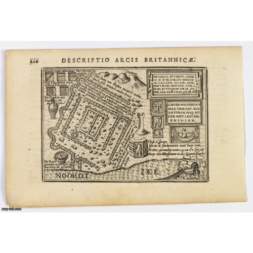
Descriptio Arcis Britannicae.
An original early 17th century copper engraved miniature antique map of the Roman remains in the sand dunes near Katwijk aan Zee in south Holland by Petrus Bertius. In Roman times, Katwijk was a place of strategic importance. It was located at the Roman Empire's northern border, at the mouth of the Rhine river, which in Roman times was larger in this area than it is today. There was a good deal of traffic along the Rhine. Katwijk was also a jumping-off point for the voyage to Britain. The map i...
$100
Maker : LANGENES, B. / BERTIUS, P.
Place : Amsterdam
Date : 1606
Postage & Shipping
-
Item Location
Terms and conditions - Item Location
- 75013, Ile-de-France, France
- Ships To
- United States, United Kingdom, Albania, Argentina, Armenia, Australia, Azerbaijan, Bahamas, Belgium, Bermuda, Cambodia, Canada, Chile, China, Croatia, Cyprus, Czech Republic, Denmark, Estonia, Finland, France, Germany, Gibraltar, Greece, Greenland, Guatemala, Hong Kong, Iceland, India, Indonesia, Israel, Italy, Japan, Latvia, Lithuania, Luxembourg, Malta, Mexico, Monaco, Netherlands, Norway, Singapore, Spain, Sweden, Switzerland, Turkey
- Pick-ups
- No pick-ups
This item is owned and offered by the seller Paulus_Swaen_Old_Maps - All items are available for immediate sale, offered subject to prior sale.
Invoices are created by the seller by using our shopping cart or be prepared by the seller the day following the order and are emailed to you.
Items offeres by different sellers are invoiced separately.
Shipping fees are extra. The buyer is responsible for all applicable taxes, including any VAT, customs clearance, import duties, or equivalent costs arriving at the customer's home border. Payment is due on receipt of the invoice. The item(s) are shipped as soon as possible after receipt of your payment.
Before buying please read the complete Terms Conditions of Sale.
- Payment Methods
- Visa, Mastercard, Bank Transfer, American Express, iDEAL, PayPal, Google Pay
- Returns Accepted
- No
Post Message
Feel free to ask the seller a question. Please note that the seller could be located in an area with a different time zone. Our seller will do their best to respond within 24 hours.Post your message below.
Sign in to ask the seller a question.
![[Ternate].](/uploads/cache/37954-500x500.jpg)