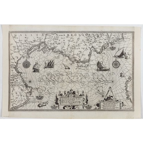
(Sea-chart of Catalunia, Languedoc, Provence, Cote d'Azur, Riviera, Corsica with Marseille, Cannes, Nice, Monaco.)
This very rare chart is important as the first printed sea chart of France's Mediterranean coast, also depicting Catalunya's northern coast, the Italian Cote d'Azur till San Remo and Corsica's west coast.Willem Barentsz (1560-1597) was a famous pilot, discoverer and cartographer. Author of 'Nieuwe Beschrhryvinghe ende caertboeck van de Midlantsche Zee', the first printed pilot-guide of the Mediterranean. It is considered the supplement of Waghenaer's 'Spieghel der Zeevaerdt' for the Mediterranea...
€4.000
Maker : BARENTSZ, Willem.
Place : Amsterdam
Date : 1607
[Lot of 17 maps] L' ISLE DE FRANCE Pariensis agri descriptio. Francois de la Hoeye fecit, Jean le Clerc excud.
The map of Ile de France which Jean Leclerc added in his re-issue of Maurice Bouguereau's atlas 'Theatre Francois' , as ' La Theatre geographique de France' in 1619. An uncommon and decorative map.[Lot of 17] maps of F R A N C E- L'Isle de France, Parisiensis agri descrip(tio). - Gouvernemens de Picardie, de Boulonnois, et d’Artois (1768)- V. Descrittione del Regno della Gallia (1598)-La France Divisée en ses quarante Gouvernamens Généraux et Militaire.- - Topographia aug. Turon. duca...
€1.000
Maker : Jean Leclerc
Place : Paris
Date : 1619
[Lot of 15 maps/plans of northern France] Gouvernement d' Orleans et la Generalite divisee en ses Elections.
Alexis-Hubert Jaillot (1632-1712), French cartographer. He joined the Sanson heirs and redrew Nicolas Sanson's maps on a larger scale. 'Atlas Nouveau' (1674), sea-atlas ' Le Neptune François' (1693).An attractive large-format map depicting Orleans and vincinity. Embellished with a large title-cartouche and a cartouche with scales.Newly engraved for the counterfeited edition of the ' Atlas Nouveau', published by Pieter Mortier in Amsterdam. Ref.: Pastoureau, Les Atlas Français XVIe-XVIIe Siècl...
€500
Maker : Jaillot, A.-H. / P. Mortier.
Place : Amsterdam
Date : 1693
[Lot of 5 maps of the mouth of the Gironde river] Carte des Entrees et Cours de la Gironde
A large sea chart of the mouth and course of the Gironde river as far inland as Bordeaux. Decorated with three cartouches.Jacques Nicolas Bellin (1702-720) was the most important French hydrographer of the 18th century. Sea-atlas 'Hydrographique Français' , 1756-65, atlas to accompany Prévost d' Exile's ' Histoire. des Voyages', 1738-75. A lot of 5 maps of the mouth of the Gironde river.- Carte des Entrees et Cours de la Gironde ((96x65 cm)- Carte du Gouvernent de Guyenne et Gascogne- Gou...
€350
Maker : BELLIN, J. N.
Place : Paris
Date : c. 1740


![[Lot of 17 maps] L' ISLE DE FRANCE Pariensis agri descriptio. Francois de la Hoeye fecit, Jean le Clerc excud.](/uploads/cache/86212-500x500.jpg)
![[Lot of 15 maps/plans of northern France] Gouvernement d' Orleans et la Generalite divisee en ses Elections.](/uploads/cache/16682-500x500.jpg)
![[Lot of 5 maps of the mouth of the Gironde river] Carte des Entrees et Cours de la Gironde](/uploads/cache/86010-500x500.jpg)