
ID: 318
Open
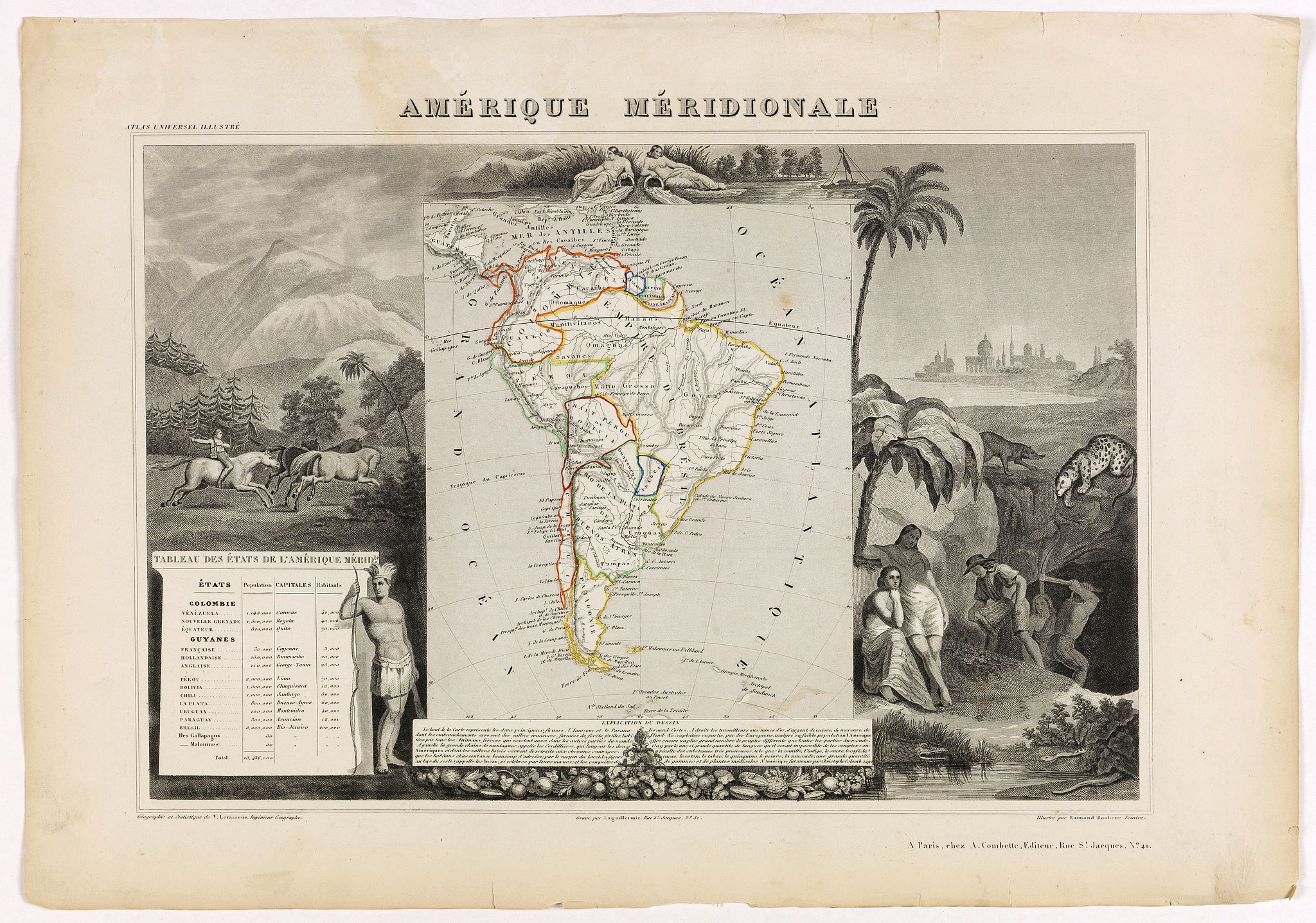
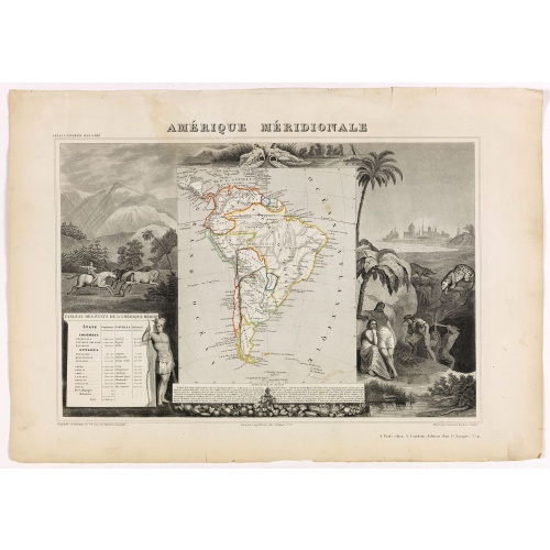
Amérique Méridionale.
BuyNow for $90
- Maker :
- LEVASSEUR, V.
- Place :
- Paris, A. Combette
- Date :
- 1852
- Color :
- Orig. out line color
- Height mm.:
- 290
- Width mm.:
- 420
- Condition :
- Very good condition. Steel engraved map in original out-line colors, the outer decoration is uncolored, as issued. Repair of some outer marginal tears.
- Bibliography :
- -
- Seller's ref. :
- 41192
This item is offered by Paulus_Swaen_Old_Maps
See other Items from this seller- Postage
-
Europe
$34 to France
- Select Country
- Zip/Post Code
- Quantity
$90
Description
Map of South America.Lovely map from one of the last decorative atlases of the nineteenth century.
The rather simple map is framed by horses, Indians, jaguars, tapirs, and mining, as well as personifications of the rivers Amazon and La Plata at the top of the map.
Victor Levasseur's "Atlas National Illustré" and "Atlas Universel Illustré" are among the last great decorative atlases published.
This map comes from the Atlas National Illustré.
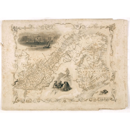
East Canada and New Brunswick.
This is John Tallis’ map of East Canada or what is now Quebec and New Brunswick. Includes Montreal, Quebec City, and the St. Lawrence River valley. Features five vignettes which include American Indian warriors and a spectacular view of Quebec City. The whole is surrounded by a decorative vine motif border. The vignettes for this map were drawn by H. Warren and engraved by J. B. Allen. The map itself is the work of John Rapkin. The Illustrations after a design by H. Warren and engraved by J Ra...
$75
Maker : TALLIS, J.
Place : London
Date : 1851

Kaart van de Reede van Batavia met de verschillende vaarwaters naar dezelve trigometrisch opgenomen op last van deb schout bijnacht E.Lucas.
Very large and rare so-called blue-black chart centered on Jakarta's harbor.The chart is prepared by B.G.Escher, I.A.C. Eschauzier, B.H.Staring and E.H.Boom during an expedition in 1841 by the ships Krokodil and Hekla. The chart is engraved by J.C.Zurcher and updated for and published in 1847 by Jacob Swart. When Gerard Hulst van Keulen died in 1801, his widow ran the firm until her death in 1810, at which time Johannes Hulst van Keulen became the last van Keulen to run the firm.In 1823, Jacob S...
$1.800
Maker : HULST VAN KEULEN, Wed. G.
Place : Amsterdam
Date : (1841) 1847
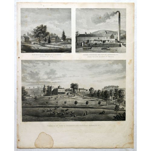
Mount Vernon Valley Residence of S.J. Powers / Borden condensed milk factory brewsters N.Y / Residence of Dan D. Chamberlain South East Putman Co. N.Y.
Three heliographic prints on one sheet : "Mount Vernon Valley Residence of S.J. Powers (135 x 155mm.) / Borden condensed milk factory brewsters N.Y (135 x 155mm.) / Residence of Dan D. Chamberlain South East Putman Co. N.Y. (190 x 155mm.) " after design by R.K.Sneden.From Beer's famous county atlas "Atlas of New York and vicinity", "a documentary record of nineteenth century life and delightful specimens of American folk art". F. W. Beers, along with other members of his family, were among the l...
$90
Maker : DE BEERS, F.W.
Place : New York
Date : 1867
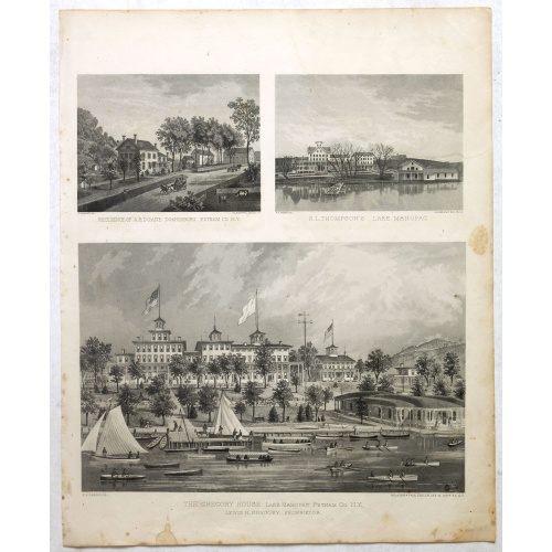
Residence of A.S. Doane Doanesburg Putnam Co. N.Y. - N. L. Thompsons's lake Mahopac - The Gregory House lake Mahopac Putnam Co N. Y. Lewis H. Gregory Proprietor.
Three heliographic prints on one sheet : "Residence of A.S. Doane Doanesburg Putnam Co. N.Y. (120x150mm.) / N. L. Thompsons's lake Mahopac (120 x 160mm.) / The Gregory House lake Mahopac Putnam Co N. Y. Lewis H. Gregory Proprietor. (210 x 320mm.)." After design by R.K.Sneden (120 x 160mm.).From Beer's famous county atlas "Atlas of New York and vicinity", "a documentary record of nineteenth century life and delightful specimens of American folk art. F. W. Beers, along with other members of his fa...
$90
Maker : DE BEERS, F.W.
Place : New York,1867
Date : 1867
Postage & Shipping
-
Item Location
Terms and conditions - Item Location
- 75013, Ile-de-France, France
- Ships To
- United States, United Kingdom, Albania, Argentina, Armenia, Australia, Azerbaijan, Bahamas, Belgium, Bermuda, Cambodia, Canada, Chile, China, Croatia, Cyprus, Czech Republic, Denmark, Estonia, Finland, France, Germany, Gibraltar, Greece, Greenland, Guatemala, Hong Kong, Iceland, India, Indonesia, Israel, Italy, Japan, Latvia, Lithuania, Luxembourg, Malta, Mexico, Monaco, Netherlands, Norway, Singapore, Spain, Sweden, Switzerland, Turkey
- Pick-ups
- No pick-ups
This item is owned and offered by the seller Paulus_Swaen_Old_Maps - All items are available for immediate sale, offered subject to prior sale.
Invoices are created by the seller by using our shopping cart or be prepared by the seller the day following the order and are emailed to you.
Items offeres by different sellers are invoiced separately.
Shipping fees are extra. The buyer is responsible for all applicable taxes, including any VAT, customs clearance, import duties, or equivalent costs arriving at the customer's home border. Payment is due on receipt of the invoice. The item(s) are shipped as soon as possible after receipt of your payment.
Before buying please read the complete Terms Conditions of Sale.
- Payment Methods
- Visa, Mastercard, Bank Transfer, American Express, iDEAL, PayPal, Google Pay
- Returns Accepted
- No
Post Message
Feel free to ask the seller a question. Please note that the seller could be located in an area with a different time zone. Our seller will do their best to respond within 24 hours.Post your message below.
Sign in to ask the seller a question.
![[Another Dutch fleet reaches Lima].](/uploads/cache/41117-500x500.jpg)