ID: 66
Closed

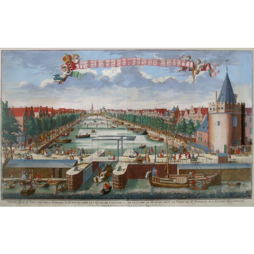
Beschrijving Gezicht van den Ykant af bezyden den Schreiers hoex Toren langs de Keulsche en Geldersche Kaei naer de Nieuwe Markt
BuyNow for $2.000
- Maker :
- DE LETH, H.
- Place :
- Amsterdam
- Date :
- ca 1720
- Color :
- Colored
- Height mm.:
- 560
- Width mm.:
- 920
- Condition :
- Etching on two joined sheets of paper.
- Bibliography :
- Auction catalog collection De Vries (1925), no. 273.
- Seller's ref. :
- 00807
This item is offered by Paulus_Swaen_Old_Maps
See other Items from this seller- Postage
-
Standard Shipping
$0 to Netherlands
- Select Country
- Zip/Post Code
- Quantity
$2.000
Description
This large engraving (560x920mm.) comes from a are series of 25 beautiful large views of Amsterdam and gives a colorful picture of the life and business of the city at the beginning of the 18th century. The print gives a view of the cityscape and architecture of that time. It also shows daily manners and customs and all kinds of scenes take place; There is a fight to the left of the bridge in the foreground (now Prins Hendrik Kade), while in front of the Scheierstoren quiet citizens read the notes posted against it.At the beginning of the Geldersekade, on the corner with the Oudezijds Kolk, is the Schreierstoren. The Schreierstoren is the only remaining defensive tower of the medieval city wall. Originally the tower rose from the water with two loopholes just above the water surface.
At the beginning of the seventeenth century, the city wall was demolished and the canal was dug. The tower was originally called the Schreiershoekstoren. Schreihoek probably refers to the sharp corner where the Geldersekade and the Oudezijds Kolk meet. However, the Schreierstoren has gone down in history as the place where many women saw their loved ones sail away while crying.
The Geldersekade owes its name to the moored barges, a type of regular scheduled service, that sailed to the cities of Gelderland after this canal was located within the new city walls.

Gelriae, Cliviae, Finitimorumque Locorum Verissima..
East to the top. Fine map of Geldria and Limburg, prepared by Christian s'Grooten. Very fine title cartouche lower right with painter's utensils around the cartouche.Dare to go in Black. All early maps were printed in black and white, and many were kept that way for a long time. A black and white map in an early and strong impression is a rarity nowadays, being so many examples recently colored up!
$250
Maker : ORTELIUS, A.
Place : Antwerp
Date : 1598

Zee caerte vande Sondt tvermaerste van Danemarcke . . .
A detailed chart of the coast of Denmark and its islands, Copenhagen in the center of the chart. West to the top. It is decorated by a title, scale and descriptive cartouche, a compass rose, several vessels and sea monsters, and depictions of mountains, fields, trees, small villages and animals.The chart shows soundings, sandbanks, landmarks and coastal profiles.Chart from an early Dutch text edition of this landmark contribution to the science of navigation. Waghenaer's own experiences as a pil...
$3.000
Maker : WAGHENAER, L. J.
Place : Leiden, Plantijn
Date : 1585

A new mape of Ye XVII Provinces of Low Germanie.
Showing all 17 Provinces of the Netherlands before the split between Spain and the Protestant Provinces under the House of Orange.The map was first published. At the same time, the war of independence was still being fought against Philip II. With columns of figures on either side and surmounted by eight city prospects. A famous and most decorative item.A fourth state published by Thomas Basset and Richard Chiswell. The date has been removed and Speed's name has been added to the title cartouche...
$2.300
Maker : SPEED, J.
Place : London, 1676
Date : 1626
![[Printed on silk] Nieuw Wassende Graaden Paskaart Vertoonende alle de bekende Zeekusten en Landen op den geheelen Aard Boodem of Werelt door Gerard van Keulen. . .](/uploads/cache/31640-500x500.jpg)
[Printed on silk] Nieuw Wassende Graaden Paskaart Vertoonende alle de bekende Zeekusten en Landen op den geheelen Aard Boodem of Werelt door Gerard van Keulen. . .
A very scarce and beautiful chart on Mercator's projection printed on silk. The map is printed on silk. With the name of Gerard van Keulen and the privilege. The map shows great interior detail, including a well-formed depiction of the Great Lakes and Mississippi River. Fort de Creveceur is shown near the Illinois River. The east coast of Siberia has been drawn after Nicolas Witsen's 1687 map of Tartary. A Great Companies Land has been added off the northwest coast of America. California is an i...
$20.000
Maker : VAN KEULEN, G.
Place : Amsterdam
Date : 1728
Postage & Shipping
-
Item Location
Terms and conditions - Item Location
- Amsterdam, , Netherlands
- Ships To
- United States, United Kingdom, Albania, Argentina, Armenia, Australia, Azerbaijan, Bahamas, Belgium, Bermuda, Cambodia, Canada, Chile, China, Croatia, Cyprus, Czech Republic, Denmark, Estonia, Finland, France, Germany, Gibraltar, Greece, Greenland, Guatemala, Hong Kong, Iceland, India, Indonesia, Israel, Italy, Japan, Latvia, Lithuania, Luxembourg, Malta, Mexico, Monaco, Netherlands, Norway, Singapore, Spain, Sweden, Switzerland, Turkey
- Pick-ups
- Buyer can pick-up
This item is owned and offered by the seller Paulus_Swaen_Old_Maps - All items are available for immediate sale, offered subject to prior sale.
Invoices are created by the seller by using our shopping cart or be prepared by the seller the day following the order and are emailed to you.
Items offeres by different sellers are invoiced separately.
Shipping fees are extra. The buyer is responsible for all applicable taxes, including any VAT, customs clearance, import duties, or equivalent costs arriving at the customer's home border. Payment is due on receipt of the invoice. The item(s) are shipped as soon as possible after receipt of your payment.
Before buying please read the complete Terms Conditions of Sale.
- Payment Methods
- Visa, Mastercard, Bank Transfer, iDEAL, PayPal, Google Pay
- Returns Accepted
- No
Post Message
Feel free to ask the seller a question. Please note that the seller could be located in an area with a different time zone. Our seller will do their best to respond within 24 hours.Post your message below.
Sign in to ask the seller a question.