
ID: 217
Open
.jpg)
Carte Generale des Dixet Sept Provinces des Pays Bas.
BuyNow for $650
- Maker :
- BEREY, N. / TASSIN, C.
- Place :
- Paris
- Date :
- 1634
- Color :
- In original outline colors
- Height mm.:
- 370
- Width mm.:
- 520
- Condition :
- Faded contemporary outline coloring. Centerfold and horizontal with paper thinning and restored. Light foxing. Else in good condition.
- Bibliography :
- Paris, catalogue LE Benelux, Loeb-Larocque, 1983, nr 17. Zurich, Zb., 4.ch.o,3.
- Seller's ref. :
- 38924
This item is offered by Paulus_Swaen_Old_Maps
See other Items from this seller- Postage
-
Europe
$35 to France
- Select Country
- Zip/Post Code
- Quantity
$650
Description
Rare map of the Low Countries, including Belgium, the Netherlands and Luxembourg after Tassin and offered for sale by the publisher N. Berey.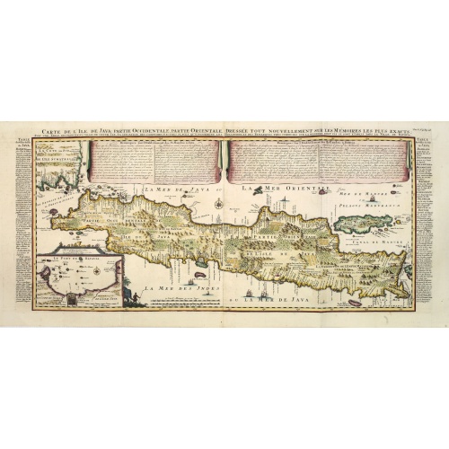
Carte de l'Ile de Java. . .
An inset plan of Batavia and clearly indicated rice fields, mountains, forests, towns in profile, and even elephants, suggesting the wealth of detail found on this map. Modeled on Hadrien Reland's important Dutch map of a few years earlier, the superb topographical detail is complemented by drapery style cartouche and side panels which provide a full French text description of the island, its topography, history, flora, fauna and inhabitants. Above the map are two drapery style title banners wri...
$1.750
Maker : CHATELAIN, H.
Place : Amsterdam
Date : 1720
![[Captain Weert dines with the Chief].](/uploads/cache/39922-500x500.jpg)
[Captain Weert dines with the Chief].
Scarce print with a German text sheet. Captain Weert and the chief ate modestly on roast plantain, smoked fish and wine fermented from palm, bought by a local woman. However, when Weert ordered Spanish wine to be brought from his ship, the chief forgot his temperance and drank so much he had to be carried to rest. Weert had to stay the night but returned to his ship in the morning.On the way back he was confronted by an ugly, naked woman carrying ashes in a box. After circling him three times an...
$80
Maker : GOTTFRIED, J.L. / DE BRY.
Place : Frankfurt, M.Merian
Date : 1633

Pas-Kaat vaneen gedeelte van de Aethiopische Zee behelsende de Kusten Zanguebar, Ajan en Abex, en een gedeelte van de Arabische Kust. . .
A finely engraved and detailed chart of the most eastern tip of Africa, including Somalia, Djibouti, Yemen, Mauritius, and many other islands in the Indian Ocean.Very rare: only included in 6th volume (so-called secret atlas) of Van Keulen's. Latitude scale, compass rose and system of rhumb lines, soundings, anchorage's, etc. Many Dutch names and a wealth of cities and information appear in the chart. The trading posts of the different nations are marked with flags. Number 47. in lower left corn...
$4.500
Maker : VAN KEULEN, J.
Place : Amsterdam
Date : 1753
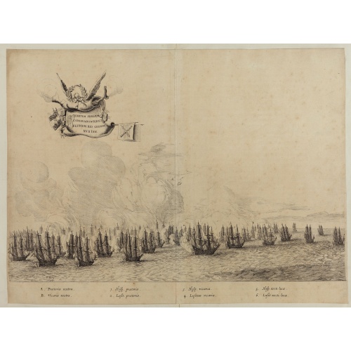
Quartum Praelium Coniovian inter et Fluvium Rio Grande XVII Ian
Decorative engraving of the fourth sea battle with the Portuguese fleet offshore at the Rio Grande, in 1640. Engraved by J. van Brosterhuyzen after a design by Frans J. Post (1612-1680). Below the engraving a numbered key (1-6). Signed in the plate "F. Post 1645" and decorative title cartouche, with "[Quartum praelium coniovian inter et fluvium Rio Grande XVII Jan" in the upper left corner.Taken from C. BARLAEUS, Rerum per octennium in Brasilia (...).
$450
Maker : POST, F. J.
Place : Joannes Blaeu, Amsterdam 1647
Date : 1647
Postage & Shipping
-
Item Location
Terms and conditions - Item Location
- Amsterdam, Florida, United States
- Ships To
- United States, United Kingdom, Albania, Argentina, Armenia, Australia, Azerbaijan, Bahamas, Belgium, Bermuda, Cambodia, Canada, Chile, China, Croatia, Cyprus, Czech Republic, Denmark, Estonia, Finland, France, Germany, Gibraltar, Greece, Greenland, Guatemala, Hong Kong, Iceland, India, Indonesia, Israel, Italy, Japan, Latvia, Lithuania, Luxembourg, Malta, Mexico, Monaco, Netherlands, Norway, Singapore, Spain, Sweden, Switzerland, Turkey
- Pick-ups
- No pick-ups
This item is owned and offered by the seller Paulus_Swaen_Old_Maps - All items are available for immediate sale, offered subject to prior sale.
Invoices are created by the seller by using our shopping cart or be prepared by the seller the day following the order and are emailed to you.
Items offeres by different sellers are invoiced separately.
Shipping fees are extra. The buyer is responsible for all applicable taxes, including any VAT, customs clearance, import duties, or equivalent costs arriving at the customer's home border. Payment is due on receipt of the invoice. The item(s) are shipped as soon as possible after receipt of your payment.
Before buying please read the complete Terms Conditions of Sale.
- Payment Methods
- Visa, Mastercard, Bank Transfer, iDEAL, PayPal
- Returns Accepted
- No
Post Message
Feel free to ask the seller a question. Please note that the seller could be located in an area with a different time zone. Our seller will do their best to respond within 24 hours.Post your message below.
Sign in to ask the seller a question.
-500x500.jpg)