
ID: 128
Open
![(Chatelain "Atlas Historique" in 7 volumes.]](/uploads/47053X.jpg)
![(Chatelain "Atlas Historique" in 7 volumes.]](/uploads/47053-5A.jpg)
![(Chatelain "Atlas Historique" in 7 volumes.]](/uploads/47053-5B.jpg)
![(Chatelain "Atlas Historique" in 7 volumes.]](/uploads/47053-7K.jpg)
(Chatelain "Atlas Historique" in 7 volumes.]
BuyNow for €40.000
- Maker :
- CHATELAIN, H.
- Place :
- Amsterdam: Chez Zacharie Châtelain
- Date :
- 1732 - 1739
- Color :
- Uncoloured
- Height mm.:
- 365
- Width mm.:
- 350
- Condition :
- 7 volumes, folio. Letterpress titles printed in red and black with engraved vignettes, six half-titles, 7 volumes, folio. in total 6 frontispieces and 287 plates. Contemporary Dutch calf gilt, spines in nine compartments with raised bands, red morocco l
- Bibliography :
- -
- Seller's ref. :
- 47053X
This item is offered by Librairie_Loeb-Larocque
See other Items from this seller- Postage
-
Standard Shipping
€0 to France
- Select Country
- Zip/Post Code
- Quantity
€40.000
Description
Henri Abraham Chatelain, whose Atlas Historique was one of the most expansive encyclopedias of the age. First published in 1705, Chatelain's Atlas Historique was part of an immense seven-volume encyclopedia. Although the main focus of the text was geography, the work also included a wealth of historical, political, and genealogical information.The text was compiled by Nicholas Gueudeville and Garillon with a supplement by H.P. de Limiers and the maps were engraved by Chatelain, primarily after charts by Delisle. The atlas was published in Amsterdam between 1705 and 1721 and was later reissued by Zacharie Chatelain between 1732 and 1739.
Chatelain was a skilled artist and knew how to combine a wealth of historical and geographical information with delicate engraving and an uncomplicated composition. Groundbreaking for its time, this work included studies of geography, history, ethnology, heraldry, and cosmography. His maps with his elegant engraving are a superb example of the golden age of French mapmaking.
Amsterdam: Chez Zacharie Châtelain, 7 volumes, folio. In total 6 frontispieces and 287 plates:
Volume 1 (1739) frontispiece and 46 plates
Volume 2 (1737) frontispiece and 37 plates.
Volume 3 (1737) frontispiece and 30 plates.
Volume 4 (1735) frontispiece and 34 plates
Volume 5 (1732)frontispiece and 57 plates
Volume 6 (1732) 39 plates (counted 1 plate for the large America, which 4 sheets have been completely joined)
Volume 7 (1732) frontispiece and 44 plates.
An ambitious and beautifully presented work, the “Atlas Historique” was intended for the general public, fascinated in the early eighteenth century by the recently conquered colonies and the new discoveries. Distant countries, such as the Americas, Africa, the Middle East, Mongolia, China, Japan, Indonesia, etc., take an important place in this work.
In addition to the maps, many of which are based on Guillaume de l'Isle, the plates are after the best travel accounts of the period, such as those of Dapper, Chardin, de Bruyn, Le Hay and others.
Other sections deal with the history of the European countries, it covers a wide range of subjects, including genealogy, history, cosmography, topography, heraldry and chronology, costume of the world, all illustrated with numerous engraved maps, plates of local inhabitants and heraldic charts of the
lineages of the ruling families of the time. The maps, prints and tables required to make up a complete set
are listed in detail in each volume.
 First published in Amsterdam from 1705 to 1720, the various volumes were updated at various
times up to 1739 when the fourth edition of vol.I appeared, stated as the "dernière edition,
corrigée & augmentée."
First published in Amsterdam from 1705 to 1720, the various volumes were updated at various
times up to 1739 when the fourth edition of vol.I appeared, stated as the "dernière edition,
corrigée & augmentée."
The first four volumes seem to have undergone four printings, with the later
printings being the most desirable as they contain the maximum number of corrections and additions.
The remaining three final volumes were first issued between 1719-1720 and revised in 1732.
The present set is made up as follows: Final edition of volume 1, third edition of vol. 2, 3,4, second edition of vols
5, 6, 7.
Henri Abraham Chatelain (1684 – 1743) was a Huguenot
pastor of Parisian origins. He lived consecutively in Paris, St. Martins, London (c. 1710), the Hague
(c. 1721) and Amsterdam (c. 1728). The publishing firm of Chatelain, Chatelain Frères and Chatelain & Fils is
recorded in Amsterdam from around 1700-1770, with Zacharias living "op den Dam" in 1730.
Henri Abraham Chatelain (1684-1743), his father Zacharie
Chatelain (d.1723) and Zacharie Junior (1690-1754), worked as a partnership publishing the Atlas
Historique, Ou Nouvelle Introduction à L'Histoire under several different Chatelain imprints,
depending on the Chatelain family partnerships at the time of publication.
The atlas was published in
seven volumes between 1705 and 1720, with a second edition appearing in 1732. The volumes I-IV with a Third edition and volume I with a final edition in 1739.
The maps were accompanied by
information about cosmography, geography, history, chronology, genealogy, topography, heraldry, and
costumes of the world.
The maps in the Atlas Historique were mainly based on those of the French
cartographer Guillaume De L’Isle, but were presented by the Chatelains in an encyclopedic form.
The accompanying text is in French and is often printed in two columns on the page with maps and other
illustrations interspersed. Each map and table is numbered consecutively within its volume and all
maps bear the privileges of the States of Holland and West-Friesland.
The encyclopedic nature of the work as a whole is reflected in these six frontispieces. The pages are the work of the celebrated mr. Romeijn de Hooghe. And are engraved by J.Goeree, T.Schynyoet and P.Sluyter.
The first volume concerns the ancient world and contemporary Italy, France, and Spain. Eight of the double-page maps are of ancient political and geographical boundaries and locations, plus city views of Rome. The volume also includes genealogical and historical charts and tables. Two maps touch on North America: Plates 2 and 4, double-hemisphere world maps, which include North America with California shown as an island.
Volume V
This volume is devoted to Asia and contains a very fine large folding map of Java and Japan after Reland, and a fine section on China and Japan, with maps after de l'Isle.
The maps in this historical
encyclopedia are of interest for the use of East Sea, the sea between Korea and Japan, here
called "Mer Orientale ou Mer de Corée". A large portion is devoted to the History of China
and their religious aspects with mentioning the Missionary works by father Rizzi, etc.
Volume VI
Phillips records 35 maps of American interest, including twelve in vol. VI. The most important of the American interest maps is the "Carte tres curieuse de la Mer du Sud" [Goss North America 52; McLaughlin 190; Wagner 511], which depicts the history of discovery in the western hemisphere from the time of Columbus to the French explorations in North America in the late seventeenth century. Central to the detail is the large depiction of California as an island a somewhat outdated concept
at the time of publication and a contrast to the geographically accurate (relatively) delineation of
the Great Lakes and the Mississippi.
The Carte Tres Curieuse is also renowned for its illustrations of
the New World; beavers are shown at work by Niagara Falls, a fishing factory is in operation in New England,
and numerous views of New World cities are included. Medallion portraits of New World explorers show
Columbus, Vespucci, Magellan, Drake, La Salle and Dampier.
The example in the present set is a fine dark impression on four sheets joined to form a large folding sheet. (As usual a few tears on crossings of folds have been restored)
References: Koeman II, Cha 1-7 (with variant collation, as usual); Cf. Phillips Atlases 579; Goffart, Historical Atlases, p. 132; van Waning, "Chatelain's Atlas Historique" in Journal of the International Map Collectors' Society, Spring 2010.
New scholarship has suggested the compiler of the atlas, identified on the title as "Mr. C***" not to
be Henri Abraham Châtelain, but Zacharie Châtelain. (See Van Waning's article in the Journal of the International Map Collectors' Society for persuasive evidence of the latter's authorship.) The images incorporated into the plates and tables are drawn from the best available contemporary sources, including the works of Dapper, Chardin, de Bruyn, Le Hay and others. Many of the maps are based on the work of Guillaume de l'Lisle.
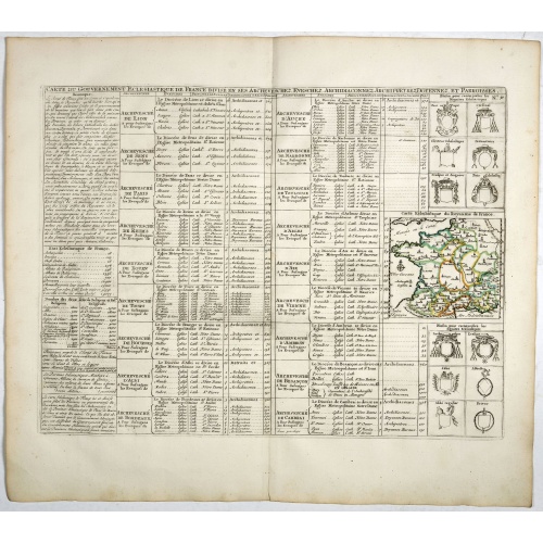
Carte du Gouvernement Ecclesiastique de France Divise en ses Archeveschez, Eveschez, Archidiaconnez, Archipretrez, Doyennez, et Parroisses.
This impressive plate provides a comprehensive list of the ecclesiastical divisions in the country with their corresponding coats of arms. A small inset map depicts the location of the various churches across France (95 x 105mm.)Zacharie Chatelain (d.1723) was the father of Henri Abraham (1684-1743) and Zacharie Junior (1690-1754).They worked as a partnership publishing the Atlas Historique, Ou Nouvelle Introduction A L’Histoire … under several different Chatelain imprints, depending on the ...
€55
Maker : CHATELAIN, H.
Place : Amsterdam, 1720
Date : 1720
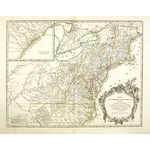
Partie De L'Amerique Septentrionale... Le Cours De L'Ohio, La N.lle Angleterre, a Nlle York, le New Jersey , La Pensyvanie, Le Maryland, Le Virginie, La Carolina...1755
From the Atlas Universel , a detailed map extending the length of the east coast from Penobscot Bay to Cape Fear and, in an inset, from Cape Fear to Fort St.Georges.This state with a dotted border of Treaty of Paris, 1763, with Virginie and Caroline Sept. Et Merid. Extended west to Mississippi. New-Hemp-Shire" and Prov. De Sagadahock" now added.The Atlas Universel of Gilles and Didier Robert de Vaugondy was first published in 1755. The maps were detailed, precisely engraved and not given to the ...
€800
Maker : DE VAUGONDY, R. de
Place : Paris
Date : 1768
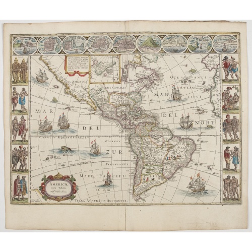
Americae Nova Tabula.
An inset shows Greenland and Iceland. Decorative elements include ships, sea monsters, and vignettes of native Americans within South America. In addition, the map is bordered by a series of nine maps and birds-eye views at the top (including Cusco, Havana, and Mexico City) and ten ethnographic views of various Native Americans.The delineation of the coast and the nomenclature on both the Pacific and Atlantic coasts are basically Spanish in origin and follow the maps of Ortelius and Wytfliet. To...
€6.500
Maker : BLAEU, W.
Place : Amsterdam
Date : 1644
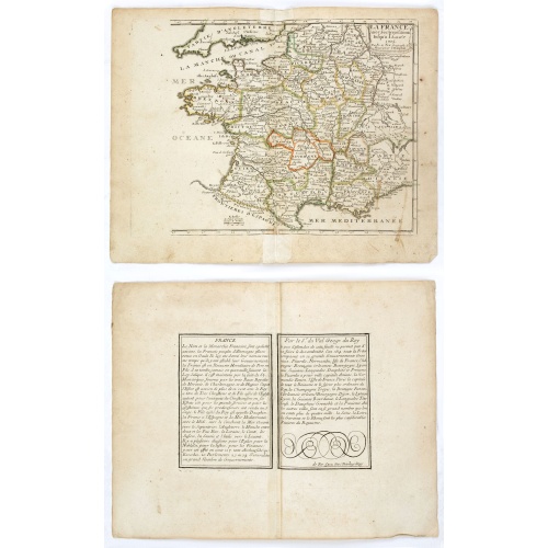
La France avec ses acquisitions jusqu'à l'année 1705.
An interesting small map of France by Nicolas de Fer. From his rare "Petit et Nouveau Atlas". The first edition was published in 1697 and was republished in 1705 and 1723. The finely engraved map is dated 1705 and was engraved by C. Inselin, the same engraver who engraved the maps in de Fer's later Atlas Curieux, published 1700-1705.
€75
Maker : DE FER, N.
Place : Paris
Date : 1705
Postage & Shipping
-
Item Location
Terms and conditions - Item Location
- 75013, Ile-de-France, France
- Ships To
- United States, United Kingdom, Albania, Argentina, Armenia, Australia, Austria, Bahamas, Belgium, Bermuda, Bosnia and Herzegowina, Brazil, Bulgaria, Canada, Chile, China, Costa Rica, Denmark, Dominica, Egypt, El Salvador, Finland, France, Germany, Greece, Guatemala, Hong Kong, Hungary, Iceland, India, Italy, Japan, Korea (South), Kuwait, Liechtenstein, Lithuania, Luxembourg, Madagascar, Mexico, Monaco, Morocco, Netherlands, Netherlands Antilles, New Zealand, Norway, Paraguay, Peru, Philippines, Poland, Portugal, Qatar, Reunion, Romania, San Marino, Saudi Arabia, Seychelles, Singapore, Slovenia, South Africa, Spain, Sri Lanka, Suriname, Sweden, Switzerland, Taiwan, Thailand, Tunisia, Turkey, United Arab Emirates, Uruguay, Vietnam
- Pick-ups
- Buyer can pick-up
This item is owned and offered by the seller Librairie_Loeb-Larocque - All items are available for immediate sale, offered subject to prior sale.
Invoices are created by the seller by using our shopping cart or be prepared by the seller the day following the order and are emailed to you.
Items offeres by different sellers are invoiced separately.
Shipping fees are extra. The buyer is responsible for all applicable taxes, including any VAT, customs clearance, import duties, or equivalent costs arriving at the customer's home border. Payment is due on receipt of the invoice. The item(s) are shipped as soon as possible after receipt of your payment.
Before buying please read the complete Terms Conditions of Sale.
- Payment Methods
- Bank Transfer
- Returns Accepted
- No
Post Message
Feel free to ask the seller a question. Please note that the seller could be located in an area with a different time zone. Our seller will do their best to respond within 24 hours.Post your message below.
Sign in to ask the seller a question.
![(Chatelain "Atlas Historique" in 7 volumes.]](/uploads/cache/47053X-500x500.jpg)